Trindade and Martim Vaz Archipelago: Brazil's Remote Atlantic Outpost
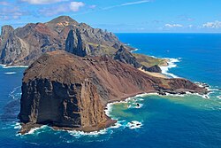
Isolated in the vast expanse of the South Atlantic Ocean, the Trindade and Martim Vaz archipelago serves as a strategic and scientific sentinel for Brazil. Located approximately 1,100 kilometres (680 miles) east of the coast of Espírito Santo, these volcanic remnants are more than just rocky outcrops; they are critical biodiversity hotspots and sites of complex geopolitical history.
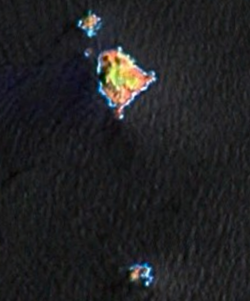
The archipelago comprises five islands and several stacks, totaling an area of 10.4 square kilometres (4.0 square miles). The dominant landmass is Trindade, which covers 10.1 square kilometres (3.9 square miles), while the smaller Martim Vaz islets, located about 49 kilometres (30 miles) to the east, cover just 0.3 square kilometres (70 acres).
Key Facts
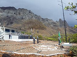
- Administration: Managed by the 1st Naval District of the Brazilian Navy.
- Highest Point: Pico do Desejado, reaching 620 metres (2,030 feet).
- Origin: Volcanic, with the last eruption occurring at Vulcão de Paredão.
- Biodiversity: Primary Brazilian nesting site for green sea turtles and home to the endemic Trindade petrel.
- Population: No permanent civilian population; supports a research station for up to 8 people and a navy garrison of 32.
Geography and Terrain
The islands are characterized by rugged, mountainous terrain. Trindade is a desiccated volcanic island featuring several prominent peaks, including Pico da Trindade (590 m) and Pico Bonifácio (570 m). One of its most striking landmarks is Pico Monumento, a cylindrical peak rising 270 metres from the west coast.
The archipelago is divided into several distinct geographical features:
- Ilha da Trindade: The largest island in the group.
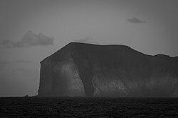
- Ilhas de Martim Vaz: A group of islets including Ilha da Racha (the largest of the group at 175 m high), Ilha do Norte, and the rocky pinnacle of Ilha do Sul, which marks the easternmost point of Brazil.
- Rochedo da Agulha: A flat, circular rock standing 60 metres high.
Environmental Challenges
Historically, Trindade was heavily forested with Colubrina glandulosa trees. However, the introduction of non-native species—such as sheep, goats, and pigs—combined with indiscriminate logging, led to the total destruction of these forests by around 1850. This deforestation caused severe soil erosion, with a loss of 1 to 2 metres of fertile topsoil and the depletion of several natural springs.
Biodiversity and Wildlife
Despite the environmental degradation, the archipelago remains a vital sanctuary for marine and avian life. It is the primary nesting ground for green sea turtles in Brazil and serves as a nursery for humpback whales.
The islands are also essential for breeding seabirds. They host endemic subspecies of the Great frigatebird (Fregata minor nicolli) and the Lesser frigatebird (F. ariel trinitatis). Notably, it is the only known breeding site for the Trindade petrel in the Atlantic Ocean.
A Turbulent History
Discovered in 1502 by Portuguese explorer Estêvão da Gama, the islands were part of the Portuguese Empire until Brazil's independence in 1822. Because of their strategic location, they have attracted various international interests over the centuries.
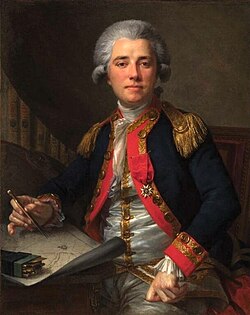
In 1700, the English astronomer Edmund Halley took possession of Martim Vaz for the British Monarchy, leaving behind goats and hogs that persisted for centuries. The islands also saw the wreck of the HMS Rattlesnake in 1781, leading to a temporary British settlement that prompted a military response from Portugal.
The late 19th century brought eccentric claims and diplomatic disputes. In 1893, James Harden-Hickey declared himself "James I, Prince of Trinidad," establishing a mock government with its own stamps and bonds. More seriously, the United Kingdom occupied Trindade from 1895 to 1896 to use it as a cable station, before an agreement returned sovereignty to Brazil.
The 20th century saw further activity, including a visit by Captain Robert Falcon Scott's Terra Nova expedition in 1910 and the 1914 Battle of Trindade, where the British HMS Carmania sank the German SMS Cap Trafalgar.
Summary of the Archipelago
| Feature | Trindade Island | Martim Vaz Islets |
|---|---|---|
| Area | 10.1 km² | 0.3 km² |
| Highest Point | Pico do Desejado (620 m) | Ilha da Racha (175 m) |
| Primary Use | Navy Base & Research | Uninhabited / Wildlife |
| Key Wildlife | Green Sea Turtles, Petrels | Seabirds |
Frequently Asked Questions
Who currently administers the islands?
The archipelago is part of the state of Espírito Santo, Brazil, and is administered by the 1st Naval District of the Brazilian Navy.
What is the highest point in the archipelago?
The highest point is Pico do Desejado on Trindade Island, which reaches an elevation of 620 metres (2,030 feet).
Why did the forests on Trindade disappear?
The forests were destroyed due to the introduction of invasive animals like goats and sheep, as well as indiscriminate tree cutting, which led to massive soil erosion.
What is the significance of Ilha do Sul?
Ilha do Sul is geographically significant as it represents the easternmost point of Brazilian territory.
Which rare birds breed on these islands?
The islands are the only Atlantic breeding site for the Trindade petrel and host endemic subspecies of the Great and Lesser frigatebirds.