Tres de Febrero: A History of Urbanization and Growth
The story of the Tres de Febrero Partido is a reflection of the broader evolution of the Metropolitan Area of Buenos Aires. From its origins as indigenous territory to its development into a structured municipality, the region has transitioned from a rural agricultural hub to a densely populated urban center.
Indigenous Roots and Early Colonial Settlement
Long before the arrival of Europeans, the lands of Tres de Febrero were inhabited by the Querandí Indians. These indigenous people established their settlements near watercourses, specifically along the Reconquista River and the Medrano, Maldonado, and Morón streams. Their economy was based on the cultivation of beans, squash, and corn. While they fought tenaciously to defend their lands during the Spanish conquest, they were eventually defeated and forced to submit to the conquerors.
The formal process of settlement began in 1580 with the second foundation of Buenos Aires by Juan de Garay. Garay implemented a system of land grants that included solars (residential lots), farms, and estates. These lands were dedicated to dairy production and the growing of cereals and vegetables, positioning the area as a primary agricultural supplier for the city of Buenos Aires until the early 20th century.
In the early 18th century, the region—then known as Pago de las Conchas—was renamed the Curato de San Isidro. This administrative area encompassed what are now the partidos of San Isidro, San Martín, Vicente López, and Tres de Febrero.
The Catalyst of Transport and Urbanization
The transition from rural estates to urban settlements was driven primarily by advancements in transportation. The installation of the railroad in 1876 served as the first major catalyst for growth. Initially, the only hub was the Caseros Station, which became the center for local commerce, housing, and administration.
Parallel to the rail expansion, the Lacroze brothers introduced a rural tram system, which transitioned to electric power in 1908. Running from the intersection of Corrientes and Medrano streets to the village of San Martín, the tramway made the area more accessible and, combined with low property costs, spurred significant demographic growth.
By the early 1900s, the railroad network expanded further, leading to the creation of new stations and residential hubs, including:
- Santos Lugares (1906)
- Ciudadela (1910)
- Sáenz Peña (1910)
In June 1920, the Argentine Red Cross established a branch in Santos Lugares at 3670 Severino Langeri Street. This institution became a cornerstone of community health, led by distinguished physicians such as Canepa, Carbone, and Cerazo.
Industrial Expansion and Military Influence
The 1930s marked a shift in development patterns. The introduction of the colectivo (bus) in 1930 allowed for the emergence of housing developments and industrial settlements in areas located between railroad stations.
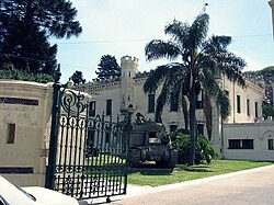
Military presence also played a pivotal role in the region's layout. The establishment of Ciudadela and Campo de Mayo in 1901, followed by the opening of the Colegio Militar de la Nación in 1937, resulted in military installations occupying approximately 12% of the partido's total area.
The final phase of urbanization occurred between 1970 and 1972, as vacant lands to the northwest were subdivided to create neighborhoods such as Once de Septiembre, Remedios de Escalada, Churruca, El Libertador, and Loma Hermosa.
The Formation of the Municipality
The official creation of the partido was proposed in 1958 by deputy Alfredo Longo. Under Law 6.065 of the Buenos Aires Province, the Tres de Febrero Partido was formally established in 1959, separating from the San Martín partido. The name commemorates the Battle of Caseros, fought on February 3, 1852, between the forces of General Urquiza and Juan Manuel de Rosas.
The municipality began its official operations on January 1, 1960, with Ramón Landin serving as the first mayor until 1962. Initially, municipal offices were scattered across fourteen different sites due to a lack of adequate facilities.
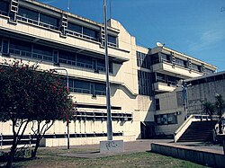
The Municipal Edifice "Heroes de Malvinas"
To centralize administration, the government negotiated with Ferrocarriles Argentinos for land between Juan Bautista Alberdi and General Hornos streets. A project by architects Eduardo Sarrailh and Odilia Suárez was selected in 1968. Despite bankruptcy issues with the construction company Sucesión Carlos Rinadi, the project eventually progressed.
The building, characterized by exposed concrete and aluminum carpentry, was named "Heroes de Malvinas" in 1983 to honor those who died in the Falklands War. The Concejo Deliberante officially moved into the facility in 1987.
Further infrastructure improvements followed, including the February 1988 opening of the Libertador San Martín avenue tunnel in central Caseros, inaugurated by mayors Jorge Mangas and Héctor Dáttoli.
Key Facts
- Indigenous Origins: Originally inhabited by the Querandí people who farmed corn, squash, and beans.
- Naming: Named after the Battle of Caseros (February 3, 1852).
- Transport Drivers: Growth was fueled by the 1876 railroad, the 1908 electric tram, and the 1930 introduction of buses.
- Military Impact: Military sites account for 12% of the partido's land area.
- Administrative Birth: Formally separated from San Martín partido in 1959 via Law 6.065.
| Period/Year | Key Event/Development | Impact |
|---|---|---|
| 1580 | Juan de Garay's land grants | Initiated agricultural settlement |
| 1876 | Railroad installation | First urban settlements (Caseros) |
| 1908 | Electric tramway | Increased demographic settlement |
| 1906-1910 | New rail stations | Growth of Santos Lugares, Ciudadela, and Sáenz Peña |
| 1959 | Law 6.065 | Official creation of Tres de Febrero Partido |
| 1970-1972 | Northwest subdivision | Completion of urbanization process |
Frequently Asked Questions
Why is the partido named Tres de Febrero?
The name refers to February 3, 1852, the date of the Battle of Caseros, which took place on lands within the current partido between the forces of General Urquiza and Juan Manuel de Rosas.
Who were the original inhabitants of the area?
The area was originally inhabited by the Querandí Indians, who lived near watercourses like the Reconquista River and cultivated crops such as corn, beans, and squash.
How did transportation influence the growth of the region?
The 1876 railroad created the first urban hubs, the 1908 electric tram stimulated population growth due to accessibility, and the 1930 introduction of buses (colectivos) allowed for industrial and residential expansion away from rail stations.
What is the significance of the "Heroes de Malvinas" building?
It is the Municipal Edifice of Tres de Febrero, designed by architects Odilia Suárez and Eduardo Sarrailh. It was named in 1983 as a tribute to those who died in the Falklands War.
Which military installations influenced the area's development?
The settlement was significantly influenced by Campo de Mayo, the military installations in Ciudadela (established 1901), and the Colegio Militar de la Nación (opened 1937).