St Ives Bridge: A History of Architecture and Resilience
For centuries, the town of St Ives has served as a vital religious and agricultural hub. Situated on the north bank of the River Great Ouse, the town's growth was inextricably linked to the ability of travelers to cross the water on their way to London. What began as a simple ford—a shallow place where a river may be crossed by wading—evolved over a millennium into one of England's most distinctive architectural landmarks.
The settlement, originally known as Slepe, was developed around AD 1000 by the Abbot of Ramsey Abbey, likely Ednoth, who established the Priory of St Ivo. By 1110, the town had secured a Royal Charter from King Henry I to host an annual fair, necessitating better infrastructure. This led to the construction of the town's first wooden bridge in 1107.
Because the southern bank consisted of a marshy flood plain, a causeway was constructed to bridge the gap. This causeway featured a series of small bridges over natural watercourses, connected by raised earth embankments reinforced with brushwood or stones.
The Transition to Stone
Wooden structures required constant maintenance, leading to the decision in 1414 to build a permanent stone arch bridge. Constructed between 1415 and 1426, the bridge was crafted from Barnack limestone, which was transported approximately 30 miles from quarries near Peterborough on the River Welland.
Upon its completion, a chapel dedicated to St Leger (also known as Ledger or Leodegarius) was built onto one of the bridge's piers. These bridge chapels were common at the time, providing a sanctuary where travelers could pray for protection or offer thanks for a safe journey.
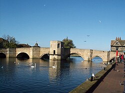
The 16th century brought significant political and social change. In 1539, during the dissolution of the monasteries under King Henry VIII, Ramsey Abbey was closed. This resulted in the separation of the bridge and the chapel: the bridge became a lucrative asset of the Manor of St Ives due to its toll-collecting rights, while the chapel was converted into a private residence. The bridge remained crown property until 1628, when King Charles I sold it to the Earl of Manchester.
Civil War and Structural Evolution
The English Civil War left a physical mark on the bridge. In 1645, Roundhead forces under Oliver Cromwell partially demolished the bridge—along with those at St Neots and Huntingdon—to prevent Cavalier forces from moving north toward Cambridge. The two southern arches were destroyed and replaced with a drawbridge.
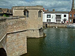
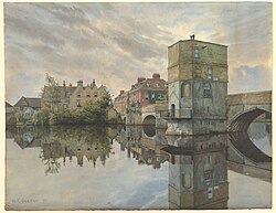
This drawbridge remained in place until 1716, when the Duke of Manchester reinstated the missing spans. Because the rebuilding techniques had changed, the new southern arches were rounded (segmental), while the original northern arches remained Gothic in style. This creates the unique architectural hybrid seen today: two Gothic arches from 1426 and two rounded arches from 1716.
Technical Specifications of the Bridge
- Roadway Width: 12 feet 6 inches between parapets.
- Gothic Spans: Range from 13 to 30 feet, featuring five ribs and weather drip moulds.
- Southern Spans: Segmental arches with spans of 16 and 21 feet.
The New Bridges and the Southern Approach
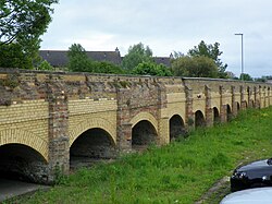
By the early 19th century, the southern causeway had fallen into severe decay. Reports from 1810 described the route as "ruinous, broken, washed away," and "drowned." As the bridge was part of a major turnpike route between Bury and Stratton, the Turnpike trust was legally obligated to maintain it.
Following an Act of Parliament in 1819, the Duke of Manchester funded a massive infrastructure project. On September 17, 1822, a 200-yard viaduct consisting of 55 low arches was opened. Known as The New Bridges, this structure is now a Grade II* listed landmark.
The Evolution of the Chapel
The chapel's history is as varied as the bridge's. After its deconsecration in 1539, it served as a private home and later as a public house. In 1736, two brick storeys were added to the building, significantly altering its profile.
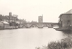
By 1930, the added weight of these storeys had weakened the structure. They were removed during a restoration project that included the installation of a modern roof. One of the chapel's most striking features is its crypt, located approximately two metres above the river's water level. Today, the bridge and chapel are Grade I listed and designated as a scheduled monument, with the chapel occasionally hosting public worship.
Modern Era: Tolls and Traffic
The bridge remained a source of contention into the 20th century due to the tolls levied by its owners. In 1921, the Huntingdonshire County Council adopted both the main bridge and The New Bridges, finally abolishing the tolls. In 1928, the chapel was purchased by two council members and gifted to the council, reuniting the bridge and chapel under single ownership.
Until 1980, the bridge carried the B1040 road and served as the primary southern access to the town. The heavy burden of buses and lorries was finally relieved with the construction of the Harrison Way by-pass, which diverted traffic to the east of the town center.
Key Facts
- Original Construction: First wooden bridge built in 1107; stone bridge built 1415–1426.
- Materials: Constructed using limestone from Barnack, quarried near Peterborough.
- Architectural Mix: Features both Gothic (north) and segmental (south) arches.
- The New Bridges: A Grade II* listed viaduct with 55 arches, completed in 1822.
- Legal Status: The bridge and chapel are Grade I listed and a scheduled monument.
- Traffic Shift: Heavy traffic was diverted away from the bridge in 1980 via the Harrison Way by-pass.
| Period/Date | Key Development | Significance |
|---|---|---|
| c. 1000 AD | Ford and Priory established | Founding of the settlement (Slepe) |
| 1107 | Wooden Bridge built | First formal river crossing |
| 1415–1426 | Stone Bridge constructed | Permanent limestone structure with chapel |
| 1645 | Partial Demolition | Civil War defense; replaced by drawbridge |
| 1716 | Southern Spans rebuilt | Introduction of rounded segmental arches |
| 1822 | The New Bridges opened | 55-arch viaduct to replace marshy causeway |
| 1921 | Toll Abolition | Bridge adopted by Huntingdonshire County Council |
| 1930 | Chapel Restoration | Removal of 18th-century additions |
Frequently Asked Questions
Why does the bridge have two different styles of arches?
The northern arches are original Gothic spans from 1426. The southern arches were demolished during the English Civil War in 1645 and replaced by a drawbridge; when they were finally rebuilt in 1716, the builders used a rounded segmental design instead of the original Gothic style.
What was the purpose of the chapel on the bridge?
The chapel, dedicated to St Leger, was designed to allow travelers to pray for safety or give thanks for a successful journey across the river.
What are "The New Bridges"?
The New Bridges is a Grade II* listed viaduct completed in 1822. It consists of 55 low arches and was built to replace a decaying, marshy causeway on the southern approach to the town.
Who owned the bridge over time?
Ownership shifted from the Abbot of Ramsey Abbey to the Manor of St Ives (Crown property), then to the Earl of Manchester in 1628, and finally to the Huntingdonshire County Council in 1921.
Is the chapel still used today?
Yes, although it was deconsecrated in 1539 and used as a home and a public house for centuries, it is now a restored monument used for public worship on an occasional basis.