Hurricane Rita: The Devastation of a Category 5 Storm
Hurricane Rita was one of the most powerful tropical cyclones of the 2005 Atlantic hurricane season, remembered for its extreme intensity and the chaotic evacuations it triggered. Reaching the peak of the Saffir-Simpson scale—a system used to classify hurricanes based on their sustained wind speed—Rita became a Category 5 monster that left a trail of destruction across the Caribbean and the United States Gulf Coast.
From its formation in the Atlantic to its final dissipation, Rita's journey was marked by rapid intensification and a devastating landfall that challenged emergency management systems already strained by previous storms.
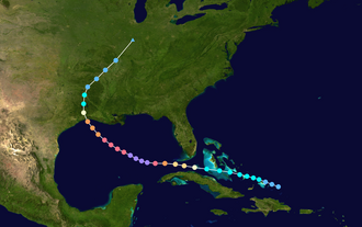
Key Facts
- Peak Intensity: Category 5 major hurricane.
- Maximum Sustained Winds: 180 mph (285 km/h).
- Lowest Central Pressure: 895 mbar, tying for the lowest ever recorded in the Gulf of Mexico.
- Total Fatalities: 120 deaths (7 direct, 113 indirect).
- Economic Damage: $18.5 billion (2005 USD).
- Lifespan: September 18 to September 26, 2005.
Meteorological History
Rita began as a tropical system on September 18, 2005. As it moved through the Caribbean, it initially impacted the Bahamas as a tropical storm, bringing heavy rain and strong winds to the region.
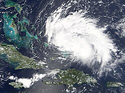
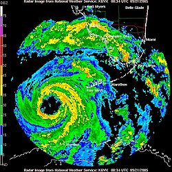
As the storm progressed westward, it crossed the Florida Straits as a Category 2 hurricane, bringing significant weather disruptions to the Florida Keys and the mainland.
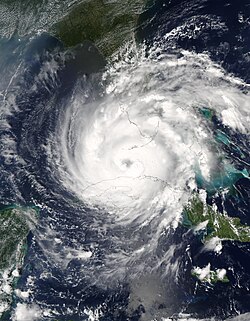
Once Rita entered the warm waters of the Gulf of Mexico, it underwent rapid intensification. By September 21, it reached Category 5 status, with a minimum central pressure of 895 mbar. This pressure reading tied the record for the lowest pressure ever recorded in the Gulf of Mexico, signaling a storm of historic proportions.
Preparations and Mass Evacuations
The threat of Rita prompted massive preparation efforts across Cuba, Florida, Louisiana, and Texas. In Cuba, approximately 150,000 people were evacuated to avoid the storm's impact. In the United States, the proximity of the storm to oil and gas refineries in the Gulf led to the idling of production, impacting energy output.
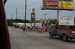
The evacuation in Texas became one of the most challenging aspects of the disaster. Millions of residents fled the coast, leading to massive traffic gridlock on major highways. These conditions contributed to a high number of indirect fatalities, as motorists were stranded in extreme heat and congestion.
Impact and Destruction
Hurricane Rita's impact was felt across several states, though Texas bore the brunt of the devastation. The storm brought a lethal combination of storm surge—the abnormal rise of water pushed toward the shore by strong winds—and torrential rainfall.
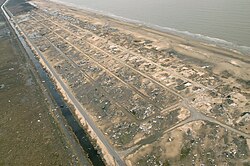
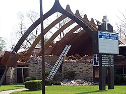
In Texas, coastal communities were devastated. Holly Beach was almost completely leveled by the surge, and cities like Beaumont saw significant structural damage, including the loss of roofs on public buildings.
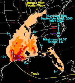
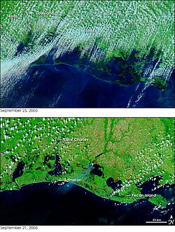
Flooding was widespread, particularly near Galveston Bay and in Louisiana. Satellite imagery later revealed the massive extent of the inundation across the Texas and Louisiana coastlines.
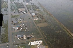
The human cost was severe. While only 7 deaths were classified as direct results of the storm (such as drowning or wind-related injuries), 113 deaths were indirect, many occurring during the frantic evacuation process in Texas.
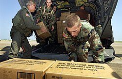
Recovery efforts involved significant military support. Soldiers utilized CH-47 Chinook helicopters to transport water and Meals, Ready-to-Eat (MREs) to affected areas, such as Ellington Field, Texas, to support survivors.
Storm Summary
| Metric | Detail |
|---|---|
| Highest Sustained Winds | 180 mph (285 km/h) |
| Lowest Pressure | 895 mbar (26.43 inHg) |
| Total Deaths | 120 |
| Direct Deaths | 7 |
| Indirect Deaths | 113 |
| Total Damage | $18.5 Billion (2005 USD) |
Frequently Asked Questions
What made Hurricane Rita historically significant?
Rita is historically significant for its intensity, reaching Category 5 status with a minimum pressure of 895 mbar, which tied the record for the lowest pressure ever recorded in the Gulf of Mexico.
Why were there so many indirect deaths compared to direct deaths?
The vast majority of fatalities (113 out of 120) were indirect, largely resulting from the mass evacuation of the Texas coast, which led to extreme traffic congestion, heat-related deaths, and accidents.
Which areas were most affected by the storm surge?
Coastal Texas was most severely impacted, with Holly Beach being almost completely leveled by the surge and significant flooding occurring near Galveston Bay.
How did Hurricane Rita affect the energy sector?
The storm forced oil and gas companies to idle refineries and halt production in the Gulf of Mexico as a precautionary measure, which temporarily impacted energy output.
What happened to the name "Rita" after the storm?
Due to the extreme damage and loss of life caused by the storm, the name Rita was retired from the list of Atlantic hurricane names.