Horsh Beirut: The History and Evolution of Lebanon's Urban Oasis
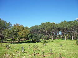
In the heart of Lebanon's bustling capital lies Horsh Beirut, a vital sanctuary of greenery amidst the dense urban landscape. Also known as Horsh El Snaubar (Arabic for "Pine Forest") or Bois de Pins in French, this urban park serves as one of the few remaining green spaces within municipal Beirut. Spanning approximately 0.3 square kilometres (0.12 sq mi), the park provides a necessary ecological and recreational respite for the city's residents.
The park is situated at the southern border of the city, forming a triangular shape bounded by Abdelnasser Avenue, 22 November Avenue, Omar Beyhum Street, and the National Museum of Beirut.
Key Facts
- Total Area: Approximately 0.3 square kilometres (0.12 sq mi).
- Alternative Names: Horsh El Snaubar and Bois de Pins.
- Historical Peak: Covered over 1,250,000 m² in 1696.
- Current Status: Open to the general public since September 3, 2015.
- Location: Southern border of municipal Beirut, Lebanon.
A Legacy of Loss and Resilience
The history of Horsh Beirut is a reflection of the broader conflicts and urban transformations of the region. As early as the 13th century, the area was recognized for its lush vegetation; William of Tyre, a medieval prelate and archbishop, referred to the forest as "La Pinée" or "Sapinoie".
Over the centuries, the forest's timber was frequently exploited. Armies from the Crusaders, Mamluks, Ottomans, and the Allies of World War II utilized the wood to construct weapons and ships. This environmental depletion was compounded by urban development and political shifts:
- 1917: A portion of the forest was converted into an Ottoman Casino, which later became the Pine Residence during the French Mandate.
- 1921: A horse racecourse was established within the grounds.
- 1950s: State planning for new roads fragmented the remaining woodland, leading to further appropriation.
- 1958 & 1970s: The Al-Shohadaa and Rawdat al-Shaheedein cemeteries were established on park land.
The park's decline accelerated during the late 20th century. During the 1982 Israeli invasion of Lebanon, jet fighters bombed the area, causing widespread fires. Additionally, parts of the forest were repurposed as a Palestinian refugee camp. These events contributed to a significant reduction in size, shrinking from over 1,250,000 m² in 1696 to roughly 800,000 m² by 1967.
Reconstruction and Public Access
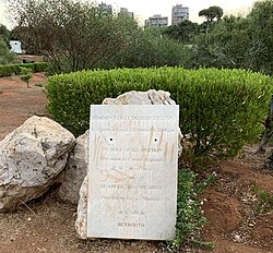
Following the Lebanese Civil War, Horsh Beirut underwent reconstruction. However, for approximately 25 years, the park remained closed to the general public. During this period, access was strictly controlled; Lebanese citizens were required to apply for permission, which was often only granted to those over the age of 35.
This restrictive policy sparked significant controversy and public protests. Reports emerged suggesting that Western foreigners were granted access more readily than Lebanese citizens, leading to accusations of unequal treatment. The tension persisted until September 3, 2015, when the Governor of Beirut, Ziad Chebib, officially reopened the park to the public.
Park Summary
| Feature | Details |
|---|---|
| Official Names | Horsh Beirut, Horsh El Snaubar, Bois de Pins |
| Current Size | 0.3 sq km (0.12 sq mi) |
| Coordinates | 33°52′16″N 35°30′36″E |
| Reopening Date | September 3, 2015 |
| Primary Vegetation | Pine trees |
Frequently Asked Questions
What is Horsh Beirut?
Horsh Beirut is a 0.3-square-kilometre urban park located in the heart of Beirut, Lebanon. It is also known as Horsh El Snaubar or Bois de Pins.
Why did the park decrease in size over time?
The park shrank due to timber exploitation by various invading armies, the construction of roads, the establishment of cemeteries and a racecourse, and damage caused by bombing during the 1982 Israeli invasion.
Was the park always open to the public?
No. After the Lebanese Civil War, the park was closed for about 25 years, with access restricted by a permit system that was often criticized for being unequal.
When did the park finally reopen to everyone?
The park was officially reopened to the general public on September 3, 2015, by the governor of Beirut, Ziad Chebib.
Where is the park located in Beirut?
It is a triangular park at the southern border of the city, limited by the National Museum of Beirut, Abdelnasser Avenue, 22 November Avenue, and Omar Beyhum Street.