Clachnaharry: A Historic Village on the Edge of Inverness
Nestled on the south shore of the Beauly Firth, Clachnaharry is a charming former fishing village that now forms part of the city of Inverness within Scotland's Highland council area. Located approximately 2 miles (3 km) west of the city centre, this settlement serves as a gateway between the rugged Highlands and the sea.
Key Facts
- Location: South shore of the Beauly Firth, Inverness, Scotland.
- Gaelic Name: Clach na h-Aithrigh, meaning "Stone of Repentance."
- Infrastructure: The starting point of the Caledonian Canal.
- History: Site of a 1454 battle between Clan Munro and Clan Chattan.
- Transport: Crossed by the Far North Line via a swing bridge.
Etymology and Meaning
The origins of the village's name have been a subject of historical debate. For some time, it was commonly believed that the name derived from the Gaelic Clach na Faire, meaning "watchman's stone," referring to local rocks used as lookout posts by the people of Inverness. However, research by Roddy Maclean in the book "The Gaelic Place Names and Heritage of Inverness" clarifies that the name actually comes from Clach na h-Aithrigh, which translates to the "Stone of Repentance."
Transport and Infrastructure
Clachnaharry is a vital point of connection for both maritime and rail transport. It marks the beginning of the Caledonian Canal, which links to the Beauly Firth through a sea lock—a specialized lock that allows vessels to transition between the canal and the fluctuating tides of the sea.
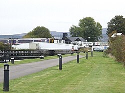
The area is also traversed by the Far North Line. To allow canal traffic to pass, the railway crosses the waterway via a swing bridge. While the village once served as a transit hub with its own railway station, which opened in 1869 as the first stop after leaving Inverness on the Inverness and Ross-shire Railway, the station eventually closed in 1913.
Military History and Heritage
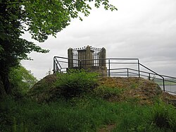
Beyond its geography, Clachnaharry is home to a significant historical landmark. A monument stands in the village to commemorate the Battle of Clachnaharry, a conflict that took place in 1454 between the Clan Munro and the Clan Chattan.
| Feature | Detail |
|---|---|
| Coordinates | 57°29′18″N 4°15′35″W |
| Council Area | Highland |
| Primary Waterway | Caledonian Canal / Beauly Firth |
| Historic Conflict | Battle of Clachnaharry (1454) |
| Former Rail Station | Open 1869 – Closed 1913 |
Frequently Asked Questions
What does the name Clachnaharry mean?
While previously thought to mean "watchman's stone," the name is derived from the Gaelic Clach na h-Aithrigh, meaning "Stone of Repentance."
Where is Clachnaharry located?
It is located on the south shore of the Beauly Firth, about 2 miles (3 km) west of Inverness city centre in the Highland council area of Scotland.
What is the significance of the Caledonian Canal in Clachnaharry?
Clachnaharry is where the Caledonian Canal begins, utilizing a sea lock to connect the canal system to the Beauly Firth.
Which clans fought in the Battle of Clachnaharry?
The battle, which took place in 1454, was fought between the Clan Munro and the Clan Chattan.
Does Clachnaharry still have a railway station?
No. Although the village had a station on the Inverness and Ross-shire Railway that opened in 1869, it closed in 1913.