Warm Fronts: How Advancing Warm Air Masses Shape Our Weather
In the complex dance of atmospheric dynamics, a warm front serves as a critical transition zone. It is a density discontinuity located at the leading edge of a homogeneous warm air mass, typically marking the equator-facing edge of an isotherm gradient. Unlike cold fronts, which move aggressively, warm fronts tend to move more slowly because the cold air they encounter is denser and more difficult to displace from the Earth's surface.
The Mechanics of Overrunning
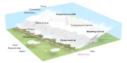
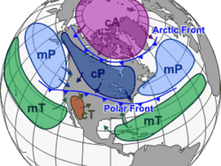
To understand a warm front, one must understand air masses—large bodies of air characterized by similar temperature and humidity levels. When a warm air mass meets a colder one, the two do not mix easily due to the difference in density. Instead, the lighter, warmer air is forced to slide upward along the upper boundary of the colder air. This meteorological process is known as overrunning.
The boundary between these air masses features a gradual slope of approximately 1:200. As the warm air rises into regions of lower atmospheric pressure, it expands and cools. This cooling causes water vapor to condense, creating the extensive cloud cover characteristic of approaching fronts.
Cloud Progression and Precipitation
The approach of a warm front is often signaled by a predictable sequence of cloud formations. The process typically begins with high-altitude cirrus clouds, which may transition into cirrostratus. If cirrocumulus clouds appear alongside them, it often indicates greater instability within the approaching air mass.
As the front draws closer, the clouds thicken and lower into middle-stage altostratus or altocumulus. This thickening is a key indicator that precipitation may arrive within six hours. Once the cloud base lowers to approximately 2,500 metres (8,200 ft), heavy nimbostratus clouds often produce steady precipitation. In unstable conditions, cumulonimbus clouds may also develop, bringing thunderstorms.
Key Facts
- Movement: Warm fronts generally move from the southwest to the northeast.
- Cloud Sequence: Typically progresses from cirrus to cirrostratus, then altostratus, and finally nimbostratus.
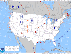
- Weather Map Symbol: Represented by a red line with semicircles pointing in the direction of travel.
- Precipitation: Often involves persistent, moderate rain or, in winter, a transition from snow to freezing rain or rain.
- Post-Frontal Conditions: Usually results in rapid warming and clearing.

Weather Characteristics Summary
| Feature | Prior to Passage | During Passage | After Passage |
|---|---|---|---|
| Temperature | Cool | Warming suddenly | Warmer, then leveling off |
| Pressure | Decreasing steadily | Leveling off | Slight rise, then decrease |
| Winds (N. Hemisphere) | South to southeast | Variable | South to southwest |
| Precipitation | Usually none (or light showers) | Persistent moderate rain | Light drizzle, ceasing |
| Visibility | Poor | Poor, but improving | Sunny/Good |
The Warm Sector
Located between the warm front and the subsequent cold front is the warm sector. This area sits on the equatorward side of an extratropical cyclone. Because the air in this sector is both warm and humid, it is highly susceptible to convective instability, which can sustain thunderstorms, particularly when lifted by an advancing cold front.
Frequently Asked Questions
How can I identify a warm front on a weather map?
On professional weather maps, a warm front is identified by a solid red line featuring semicircles that point in the direction the front is traveling.
What kind of clouds should I expect before it rains?
You will likely see high cirrus clouds first, followed by thickening cirrostratus and altostratus clouds. If the clouds thicken and lower significantly, precipitation is usually imminent.
Does a warm front always bring thunderstorms?
Not necessarily. If the air mass is stable, you will experience steady, moderate rain. However, if the air mass is unstable, thunderstorms may be embedded in the clouds before or after the front passes.
How does wind direction change during a warm front?
In the Northern Hemisphere, winds typically shift from the south or southeast to the south or southwest as the front passes.
What happens to the temperature after a warm front passes?
Once the front has passed, you can generally expect rapid warming and clearing skies.