Stationary Fronts: Understanding the Boundaries of Air Masses
In the complex world of meteorology, weather is often driven by the meeting of different air masses. When these masses collide, they create boundaries known as fronts. While many fronts move rapidly across the landscape, a stationary front (also known as a quasi-stationary front) represents a unique state of atmospheric equilibrium where neither side is winning the tug-of-war.
A stationary front occurs when two air masses advance toward each other at speeds of less than 5 knots (approximately 6 miles per hour or 9 kilometers per hour) at the ground surface. Because the movement is so minimal, the boundary remains in a relatively fixed position for hours or even days.
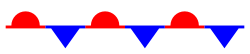
Stationary front symbol: solid line of alternating blue spikes pointing to the warmer air mass and red domes pointing to the colder air mass
Key Facts
- Movement Speed: Air masses move toward each other at less than 5 knots (6 mph).
- Duration: These fronts can remain in the same geographic area for several hours to days.
- Visual Representation: On weather maps, they are shown as a line with alternating blue spikes and red domes.
- Weather Impact: Often results in overcast skies and prolonged precipitation like rain or snow.
- Evolution: They can transform into cold or warm fronts if one air mass begins to move faster.
The Development and Movement of Stationary Fronts
Stationary fronts often develop when a cold or warm front slows down or grows over time due to underlying surface temperature differences, such as those found in coastal fronts. While the front itself appears stationary, the air is far from still. Winds on either side of the boundary often flow nearly parallel to the front, frequently moving in opposite directions.
Atmospheric waves may move eastward along the front, causing it to undulate. If atmospheric waves aloft become more intense, or if one air mass begins to advance more aggressively, the stationary front can evolve. For example, if a cold air mass moves quickly into a warm air mass, the boundary transitions into a cold front.
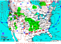
ภาพประกอบจากบทความต้นฉบับ
Transitioning into Cyclones
When atmospheric waves aloft are particularly fierce, a stationary front can facilitate the formation of one or more extratropical or mid-latitude cyclones at the surface. This transition marks a significant shift from a stable boundary to a more active, rotating weather system.
Weather Characteristics and Air Mass Dynamics
The weather experienced along a stationary front is largely determined by the moisture content of the colliding air masses. Because the front delineates the boundary between different temperatures and densities, it often creates overcast conditions. If the air masses are sufficiently humid, the front can produce persistent rain, snow, or even storm trains and mesocyclone systems.
To understand how a stationary front differs from other weather boundaries, it is helpful to compare it to the more active warm and cold fronts:
| Front Type | Typical Speed | Primary Weather Effects |
|---|---|---|
| Warm Front | 10 to 25 mph | Persistent precipitation, fog, and cloudy skies. |
| Cold Front | 25 to 30 mph (up to 60 mph) | Rapid weather changes, temperature drops, and thunderstorms. |
| Stationary Front | Less than 6 mph | Prolonged overcast skies, rain, or snow. |
Dissipation and Shear Lines
A stationary front does not last forever. It may dissipate after several days or devolve into shear lines. A shear line occurs when the air density contrast across the front vanishes—usually because temperatures have equalized—yet a narrow zone of shifting winds persists. This is most common over open oceans, where similar surface temperatures can modify both air masses. In some cases, the heat and moisture provided by the ocean can even lead to the formation of subtropical storms or tropical cyclones.
Frequently Asked Questions
How is a stationary front identified on a weather map?
On a meteorological map, a stationary front is depicted as a solid line featuring alternating blue spikes (pointing toward the warmer air) and red semi-circles or domes (pointing toward the colder air).
What causes a stationary front to move?
While the front is defined by its slow movement, it can change into a cold or warm front if one air mass begins to advance into the other at a higher speed, or if atmospheric waves aloft become more intense.
Can a stationary front cause heavy rain or snow?
Yes. If one or both of the air masses involved are very moist, a stationary front can lead to heavy or extreme precipitation, including prolonged rain or snow, especially if located in an area of low air pressure.
What is the difference between a stationary front and a shear line?
A stationary front exists where there is a clear temperature and density contrast between air masses. A shear line occurs when that temperature contrast disappears (equalization), but the wind direction continues to shift across a narrow zone.
Why do stationary fronts often result in overcast skies?
As warm air is forced to rise up and over the denser cold air (a process related to frontogenesis), the air cools and condenses, leading to the formation of clouds and persistent overcast conditions.