Shower Precipitation: Mechanics, Formation, and Types
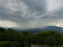
In meteorology, a shower is a specific mode of precipitation defined by its sudden onset and termination, alongside rapid fluctuations in intensity. Unlike steady, continuous rain, showers are often strong but short-lived, driven by the dynamic processes of convective clouds.
Key Facts
- Showers are characterized by abrupt starts, ends, and varying intensities.
- They primarily originate from convective clouds like cumulus congestus.
- The type of precipitation (rain, snow, or ice) depends on the temperature profile within and below the cloud.
- In meteorological reports (METAR), showers are identified by the prefix "SH".
- Extreme convective activity can lead to cumulonimbus clouds and thunderstorms.
The Science of Convection and Cloud Formation
The engine behind a shower is convection. This process begins when the Earth's surface heats the surrounding air more intensely than the atmosphere above it, particularly in a moist or conditionally unstable environment. This heating causes significant evaporation and creates rising air parcels.
As these air parcels rise into a colder environment at higher altitudes, they cool according to the adiabatic thermal gradient—the rate at which temperature changes with altitude without heat being added or removed. Once the air reaches the Lifted Condensation Level (LCL), which is the altitude where the air becomes saturated, clouds begin to form.
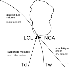
The intensity of the convection is measured by Convective Available Potential Energy (CAPE). Depending on the amount of CAPE available, clouds progress through specific stages: starting as cumulus humilis, growing into cumulus mediocris, and finally reaching cumulus congestus. It is the latter stage that typically produces the short-lived, varying precipitation known as showers.
The Life Cycle of a Shower
The life cycle of convective clouds is remarkably fast. This brevity is often caused by the updraft (the rising current of air) being cut off by the descent of the precipitation it created. Furthermore, because these clouds move with atmospheric circulation, they spend very little time over any single point on the ground, explaining why showers can appear and disappear so quickly.
Determining Precipitation Types
The specific form of precipitation—whether it is rain, snow, or ice—is dictated by the temperature structure both inside the cloud and in the atmosphere between the cloud and the ground.
Winter Conditions and Freezing Temperatures
When temperatures within the cloud are below freezing (0 °C), snowflakes are generated. The outcome depends on the air below:
- Rain: If there is a deep layer of air above freezing between the cloud and the ground, snowflakes melt into raindrops.
- Snow Pellets: If the warm layer is not deep enough, the snow may partially melt into snow pellets.
- Snow Showers/Flurries: If the temperature remains below freezing all the way to the ground, the precipitation remains as snow.
Ice and Rain Formation
In certain conditions, raindrops can form within a strong updraft even if the cloud temperature is below freezing—a phenomenon known as supercooling. These droplets can later freeze, resulting in ice pellet showers. In warmer seasons, droplets typically form and fall through above-freezing layers, resulting in standard rain showers.
Extreme Weather: Cumulonimbus and Thunderstorms
When convection becomes exceptionally intense, it produces cumulonimbus clouds. These clouds possess massive vertical extent, allowing for the displacement of electric charges between the bottom and the top of the cloud. This electrical activity produces lightning and thunder.
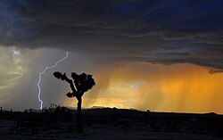
Showers associated with these massive clouds are classified as thundershowers or thunderstorms. These events are often accompanied by heavy rain, hail, and other violent meteorological phenomena.
Showery Systems and Patterns
Showers do not always occur in isolation; they can emerge from individual clouds or organized groups. In mid-latitude regions, they are frequently associated with cold fronts. However, they can also be embedded within continuous rain episodes if a band of conditional symmetric instability is present in an otherwise stable air mass. On a larger scale, showers can form part of mesoscale convective systems, such as a squall line.
Summary of Precipitation Types
| Precipitation Type | Meteorological Code (METAR) | Primary Condition |
|---|---|---|
| Rain Shower | SHRA | Above-freezing layers |
| Snow Shower | SHSN | Freezing temperatures to ground |
| Snow Pellets | SHPL | Partial melting of snow |
| Ice Pellets | SHGR | Supercooled droplets freezing |
| Hail | SHGS | Intense convective updrafts |
Frequently Asked Questions
What is the main difference between rain and a shower?
While rain can be continuous and steady, a shower is defined by its abrupt start and end, and rapid changes in intensity.
What causes the rapid changes in shower intensity?
The intensity varies because the updrafts that form the clouds are often interrupted by falling precipitation, and the clouds themselves move quickly with atmospheric circulation.
How do ice pellets form?
Ice pellets can form through supercooling, where raindrops form in a strong updraft within a cloud that is below freezing, and then freeze as they fall.
What are the METAR codes for showers?
In meteorological observations, showers are noted with the prefix SH, followed by the type: SHRA (rain), SHSN (snow), SHPL (snow pellets), SHGS (hail), and SHGR (ice pellets).
What is a cumulonimbus cloud?
A cumulonimbus is a cloud with very high vertical extent formed by intense convection, capable of producing thunderstorms, lightning, and hail.