Lapse Rate: How Temperature Changes with Atmospheric Altitude
In the study of meteorology, one of the most fundamental concepts is the lapse rate. Simply put, the lapse rate describes the rate at which an atmospheric variable—most commonly temperature—decreases as you move higher into the atmosphere. The term "lapse" is used here in the sense of "becoming less" rather than an interruption.
Understanding how temperature shifts with altitude is essential for predicting weather patterns, understanding cloud formation, and grasping the complex energy exchanges that keep our planet habitable.
Key Facts
- The Dry Adiabatic Lapse Rate (DALR) is a constant 9.8 °C/km (5.4 °F per 1,000 ft).
- The Moist Adiabatic Lapse Rate (MALR) varies based on temperature and pressure, typically ranging from 3.6 to 9.2 °C/km.
- The International Standard Atmosphere (ISA) assumes an average lapse rate of 6.50 °C/km up to 11 km.
- Convection is the primary mechanism that stabilizes the environmental lapse rate in the troposphere.
- Temperature can sometimes increase with altitude, a phenomenon known as an inversion layer.
Types of Lapse Rates
Not all temperature decreases are the same. Depending on whether the air is dry or saturated with moisture, and whether we are looking at a specific moment in time or a theoretical model, we categorize lapse rates into three main types.
Dry Adiabatic Lapse Rate (DALR)
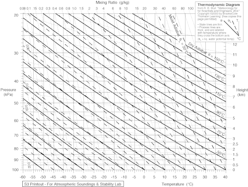
When a parcel of air rises or sinks without exchanging heat with its surrounding environment, it undergoes an adiabatic process. If this air contains very little water vapor (less than 100% relative humidity), it follows the dry adiabatic lapse rate. In this state, the temperature drops at a steady rate of 9.8 °C/km as the air expands due to decreasing pressure.
Moist Adiabatic Lapse Rate (MALR)
The presence of water vapor significantly changes how air cools. As a rising parcel of air cools, it eventually reaches its dew point—the temperature at which the air becomes saturated. At this stage, water vapor begins to condense into liquid droplets, forming clouds. This condensation process releases latent heat, which provides energy to the air parcel and slows down the cooling process.
Because of this released energy, the moist adiabatic lapse rate (also called the saturated adiabatic lapse rate) is generally lower than the dry rate, typically falling between 3.6 and 9.2 °C/km. This energy release is a critical driver for the development of powerful storms.
Environmental Lapse Rate (ELR)
While adiabatic rates describe how a specific parcel of air behaves, the environmental lapse rate describes the actual temperature profile of the atmosphere at a specific time and location. Unlike the constant adiabatic rates, the ELR is highly variable. Meteorologists use tools like radiosondes to measure the ELR and create thermodynamic diagrams to forecast weather.
Atmospheric Stability and Weather Patterns
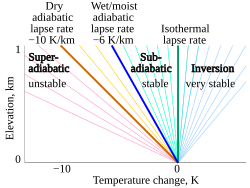
The relationship between the environmental lapse rate and the adiabatic rates determines whether the atmosphere is stable or unstable, which directly impacts weather.
- Absolutely Stable: If the ELR is less than the moist adiabatic lapse rate, rising air will cool faster than its surroundings and lose buoyancy, preventing convection. This often leads to clear skies.
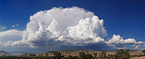
- Conditionally Unstable: If the ELR falls between the moist and dry adiabatic rates, the air is stable if unsaturated but becomes unstable if it becomes saturated. This can lead to deep, moist convection and storm development.
- Absolutely Unstable: If the ELR is greater than the dry adiabatic lapse rate, air parcels gain buoyancy as they rise, regardless of moisture levels. This condition frequently leads to cumulus clouds, showers, and thunderstorms.
Summary of Lapse Rate Values
| Lapse Rate Type | Typical Value (°C/km) | Condition |
|---|---|---|
| Dry Adiabatic (DALR) | 9.8 | Unsaturated air (low humidity) |
| Moist Adiabatic (MALR) | 3.6 – 9.2 | Saturated air (100% humidity) |
| International Standard (ISA) | 6.5 | Standardized model (sea level to 11 km) |
Frequently Asked Questions
What causes the lapse rate in the troposphere?
The lapse rate is a result of a balance between radiative cooling (where greenhouse gases and clouds emit thermal radiation to space) and convection (the upward movement of warm air). Convection helps transfer heat upward, preventing the temperature from dropping as sharply as it would by radiation alone.
How does the lapse rate affect the greenhouse effect?
A non-zero lapse rate is a prerequisite for the greenhouse effect. Greenhouse gases cause radiative cooling, which creates a temperature gradient. Without this gradient, the atmosphere would have a uniform temperature and no greenhouse effect would exist.
What is a temperature inversion?
A temperature inversion occurs when the lapse rate becomes negative, meaning the temperature actually increases with altitude. This is the opposite of the typical atmospheric behavior and can trap pollutants or moisture near the ground.
Why does saturated air cool more slowly than dry air?
When saturated air rises and cools, water vapor condenses into liquid. This condensation releases latent heat of vaporization into the air parcel, which offsets some of the cooling caused by expansion.
Does gravity affect the lapse rate?
In classical physics, a column of still air in thermal equilibrium would have a zero lapse rate. However, when considering general relativity, gravity creates an extremely small temperature gradient known as the Tolman gradient.