Semi-Arid Climates: Characteristics, Classifications, and Global Regions
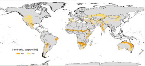
A semi-arid climate, also known as a steppe or semi-desert climate, represents a critical transitional zone in Earth's environmental spectrum. These regions occupy the middle ground between the extreme dryness of desert climates and the moisture-rich environments of humid climates. While they receive less precipitation than the potential evapotranspiration (the amount of water that would evaporate and transpire from the land if water were available) requires, they are not as arid as true deserts.
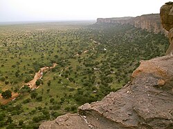
Because of their unique moisture levels, semi-arid regions typically support specific types of vegetation. Rather than dense forests, these landscapes are usually dominated by grasses or shrubs, often featuring short, thorny, or scrubby plants adapted to limited water availability.
Key Facts
- Classification: Identified by the Köppen system as BSh (hot) or BSk (cold).
- Vegetation: Primarily grasses and shrubs; generally unable to support forests.
- Temperature Threshold: The dividing line between hot and cold semi-arid climates is a mean annual temperature of 18 °C (64.4 °F).
- Precipitation: Defined by a specific threshold calculated using average annual temperature and seasonal distribution.
- Ecological Role: Acts as an intermediate zone between deserts and humid biomes.
The Köppen Classification System
To scientifically categorize these regions, meteorologists use the Köppen climate classification. This system treats steppe climates (BSh and BSk) as intermediates in terms of both ecological characteristics and agricultural potential.
Determining the Precipitation Threshold
To identify a semi-arid climate, scientists calculate a specific precipitation threshold in millimeters using the following formula:
- Multiply the average annual temperature (in °C) by 20.
- Adjust the result based on seasonal precipitation:
- Add 280 if at least 70% of total precipitation falls in the summer half of the year.
- Add 140 if 30–70% falls in the summer half of the year.
- Add nothing if less than 30% falls in the summer half of the year.
If a location's annual precipitation is less than this threshold but remains above 50% of it, the area is classified as a BS (steppe) climate.
Hot Semi-Arid Climates (BSh)
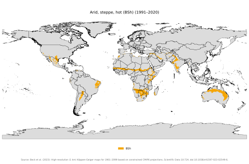
Hot semi-arid climates, designated as BSh, are typically found in the tropics and subtropics, often between the 30s and 40s latitudes. These regions frequently border subtropical deserts or tropical savanna climates. They are characterized by hot to extremely hot summers and warm to cool winters.
Geographically, BSh climates are prevalent in Africa, Australia, the Indian subcontinent, and the outskirts of the Iranian plateau. In Australia, much of the Outback surrounding central deserts falls into this category.
Other notable locations include:
- North America: Northern Mexico, the Southwestern United States (such as California's Central Valley), and the rain shadows of mountain ranges in the Dominican Republic and Haiti.
- South America: The sertão, the Gran Chaco, and areas on the poleward side of arid deserts.
- Europe: Southeastern Spain and parts of Greece, including Sicily and Sardinia.
Cold Semi-Arid Climates (BSk)
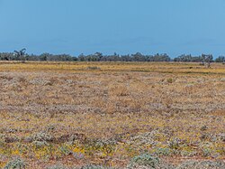
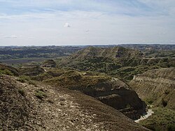
Cold semi-arid climates, or BSk, are generally located in higher elevations within temperate zones, typically between the mid-30s and low 50s latitudes. These areas often border humid continental or Mediterranean climates and are frequently found in continental interiors, far from large bodies of water.
Unlike their hot counterparts, BSk regions experience cold, and sometimes freezing, winters with occasional snowfall. They are also known for significant diurnal temperature variations—large swings between day and night temperatures that can exceed 20 °C (36 °F).
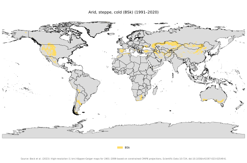
Common locations for cold semi-arid climates include:
- Central Asia and the Middle East.
- The Western United States.
- Parts of Russia, Ukraine, and Southern Europe (including Spain, Portugal, and Italy).
- Interior southern Australia (e.g., Mildura).
Climate Comparison Summary
| Feature | Hot Semi-Arid (BSh) | Cold Semi-Arid (BSk) |
|---|---|---|
| Mean Annual Temp | Above 18 °C (64.4 °F) | Below 18 °C (64.4 °F) |
| Typical Latitude | Tropics and Subtropics | Temperate Zones |
| Winter Conditions | Warm to cool | Cold to freezing |
| Temperature Swings | Generally lower | High diurnal variation |
Frequently Asked Questions
What is the main difference between BSh and BSk climates?
The primary distinction is the mean annual temperature. If the mean temperature is above 18 °C (64.4 °F), it is a hot semi-arid (BSh) climate; if it is below that threshold, it is a cold semi-arid (BSk) climate.
Can forests grow in semi-arid regions?
Generally, no. Because the precipitation is limited, these regions are usually dominated by grasses and shrubs rather than dense forests.
Where are semi-arid climates most commonly found?
Hot semi-arid climates are common in Africa, Australia, and parts of South Asia. Cold semi-arid climates are frequently found in Central Asia, the Western United States, and parts of Europe.
What does "diurnal temperature variation" mean?
It refers to the difference between the highest and lowest temperatures recorded within a single 24-hour period. This variation is particularly pronounced in cold semi-arid climates.
How is the precipitation threshold calculated?
It is calculated by multiplying the average annual temperature by 20 and then adding a specific value (0, 140, or 280) based on how much of the total annual precipitation falls during the summer half of the year.