Understanding Temperate Climates: A Guide to Earth's Middle Latitudes
When we think of the changing colors of autumn leaves or the first snowfall of winter, we are experiencing the hallmarks of a temperate climate. Unlike the consistent heat of the tropics or the enduring freeze of the polar regions, temperate zones are defined by their variability and distinct seasonal transitions. These regions serve as the middle ground of our planet, balancing the influences of both the equator and the poles.
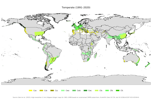
Geographically, temperate climates occur in the middle latitudes, spanning approximately 23.5° to 66.5° North and South of the Equator. While latitude is the primary driver of temperature, these climates are further shaped by continentality (the influence of the size of a landmass), prevailing wind directions, altitude, and various ocean currents.
Key Facts
- Location: Found between 23.5° and 66.5° latitude in both hemispheres.
- Temperature Range: Generally wider annual temperature fluctuations than tropical climates.
- Köppen Definition: A "temperate" (C) climate typically has the coldest month's mean temperature between −3 °C (26.6 °F) and 18 °C (64.4 °F).
- Population: The vast majority of the global human population resides in temperate zones, particularly in the Northern Hemisphere.
- Biodiversity: Southern Africa is noted for high biodiversity in temperate regions, with approximately 24,000 described taxa.
Defining the Temperate Zones
The Earth is divided into two primary temperate zones. The north temperate zone extends from the Tropic of Cancer (23.5° N) to the Arctic Circle (66.5° N), while the south temperate zone stretches from the Tropic of Capricorn (23.5° S) to the Antarctic Circle (66.5° S).
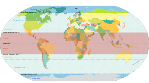
To categorize these regions scientifically, researchers often use the Köppen climate classification, a system that groups climates based on temperature and precipitation. Under this system, temperate climates (Category C) are defined by a coldest-month mean temperature above −3 °C (26.6 °F) but below 18 °C (64.4 °F). Some variations of this system set the minimum at 0 °C (32.0 °F). A broader definition may also include continental climates (Category D), which experience more extreme temperatures and coldest-month means usually below −3 °C.
The Subtropical Zone
Located between 23.5° and 35° north or south, the subtropical zone is more heavily influenced by the tropics. These areas generally experience longer, hotter summers and milder winters, with freezing precipitation being uncommon.
Humid Subtropical and Monsoon Subtropical Climates
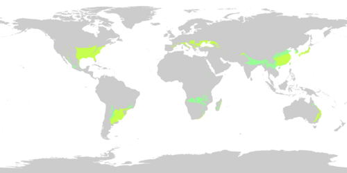
Humid subtropical climates (Cfa) are characterized by hot, humid summers with frequent convective showers and mild winters. They are typically found on the leeward lower east coasts of continents, including the southeastern United States, eastern Australia, South Africa, Ethiopia, and the Pampas region of South America. In regions like North India and southeast China, a sharper wet-dry season creates a monsoon subtropical climate (Cwa), where summers bring heavy rainfall and winters are dry and chilly.
Mediterranean Climates
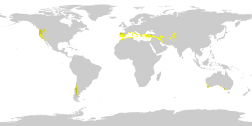
In contrast to the humid subtropics, Mediterranean climates (Csa, Csb) feature dry summers and wet winters. These are usually found on the western edges of continents, bounded by deserts to the equatorward side and oceanic climates to the poleward side. The five primary Mediterranean regions include the Mediterranean basin (North Africa, Southern Europe, and West Asia), coastal California, central Chile, the Western Cape of South Africa, and southwestern and southern Australia.
Subtropical Highland Climates
Often grouped with oceanic climates, subtropical highland climates (Cwb, Cfb) occur in mountainous areas of the tropics or subtropics. They maintain mild temperatures year-round. Those classified as Cfb have rainfall distributed evenly throughout the year, while Cwb regions are influenced by monsoons, resulting in wet summers and dry winters.
The Middle Latitude Zone
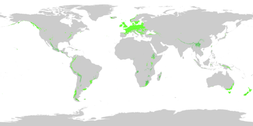
Between 35° and 66.5° north and south, the middle latitude zone receives equal climatic influence from the polar and tropical regions. This area is characterized by a distinct four-season pattern.
Oceanic Climates
Oceanic climates (Cfb) are created by the flow of cool air from high-latitude oceans to the east. This results in mild summers, cool winters, and precipitation that is evenly distributed throughout the year. Common regions include northwestern Europe, northwestern North America, New Zealand, southeastern Australia, and parts of South America.
Humid Continental Climates
Humid continental climates (Dfa, Dfb, Dwa, Dwb, Dsa, Dsb) are shaped by large landmasses and seasonal wind shifts. Unlike oceanic climates, they experience severe seasonal extremes: hot summers and cold winters. These are found in southeastern Canada, the upper eastern United States, eastern Europe, Japan, the Korean Peninsula, and parts of China.
The Subpolar Zone
Located on the poleward edge of the temperate zone, these regions are heavily influenced by polar climates while still maintaining four marked seasons.
- Subpolar Oceanic (Cfc): These are the cooler end of oceanic climates, featuring more frequent snowfall and milder winters than subarctic regions. They are found in coastal Iceland, the Faroe Islands, Scotland, northwestern Norway, the Aleutian Islands, and parts of southern Chile and Argentina.
- Cold Subtropical Highland (Cwc): Found in high-altitude areas like the Altiplano (Bolivia, Peru, Chile) and parts of Sichuan and Yunnan in China, these regions have very short summers.
- Cold Summer Mediterranean (Csc): A rare climate found in high-elevation coastal areas of the Andes and Cascades Mountains, characterized by a dry-summer pattern but prevented from freezing in winter by maritime influence.
Human and Environmental Impact
Demography and Biodiversity
Because they lack extreme temperatures, temperate zones—especially in the Northern Hemisphere—house the majority of the world's human population. These regions also support diverse life forms; for instance, southern Africa has one of the highest recorded numbers of taxa in a temperate region.
Agriculture and Urbanization
Plentiful rainfall and warm summers make temperate regions ideal for large-scale farming. While extreme weather can impact productivity, the general climate supports robust agricultural cycles in spring and summer.
The high population density in these zones has led to extensive urbanization. This creates a phenomenon where cities are warmer than surrounding rural areas. This is caused by the high absorption rate of asphalt and buildings, as well as the release of heat from burning fossil fuels in vehicles and buildings.
Summary of Temperate Climate Types
| Climate Type | Key Characteristics | Typical Regions |
|---|---|---|
| Humid Subtropical | Hot, humid summers; mild winters | SE USA, East Asia, Pampas |
| Mediterranean | Dry summers; wet winters | Mediterranean Basin, California, Chile |
| Oceanic | Mild summers; cool winters; even rain | NW Europe, NW North America, NZ |
| Humid Continental | Severe seasons; hot summers; cold winters | SE Canada, E USA, Eastern Europe |
| Subpolar Oceanic | Cool maritime influence; frequent snow | Iceland, Scotland, Aleutian Islands |
Frequently Asked Questions
What exactly defines a "temperate" climate?
In general terms, temperate climates occur in the middle latitudes between the tropics and polar regions. Scientifically, the Köppen classification defines them as having a coldest-month mean temperature between −3 °C (26.6 °F) and 18 °C (64.4 °F).
How does a Mediterranean climate differ from a Humid Subtropical climate?
The primary difference is the rainfall pattern. Humid subtropical climates have hot, humid summers with frequent rain, while Mediterranean climates have dry summers and receive most of their precipitation during the winter.
Why is the Northern Hemisphere's temperate zone more populated?
The Northern Hemisphere contains a significantly greater mass of land within the temperate latitudes compared to the Southern Hemisphere, providing more habitable space with moderate temperatures.
What is the "Urban Heat Island" effect mentioned in the text?
This refers to the phenomenon where urban areas are warmer than their rural surroundings. It is caused by the absorption of heat by buildings and asphalt, combined with heat generated by fossil fuel combustion from cars and heating systems.
What is the difference between Oceanic and Continental climates?
Oceanic climates are influenced by the ocean, leading to mild summers and cool (but not cold) winters with steady rain. Continental climates are influenced by large landmasses, resulting in more extreme temperature swings, with much hotter summers and colder winters.