riversdrainage basinswater cyclehydroelectricityriver ecology

Rivers: The Lifelines of Earth and Human Civilization

Rivers: The Lifelines of Earth and Human Civilization A river is a natural stream of fresh water that flows across land or through subterranean caves, moving toward a body of water at a l...

Rivers: The Lifelines of Earth and Human Civilization

A river is a natural stream of fresh water that flows across land or through subterranean caves, moving toward a body of water at a lower elevation, such as an ocean, lake, or another river. These powerful arteries of the planet are regulated by the water cycle—the continuous process by which water moves around the Earth. Whether sourced from rainfall, melting glaciers, snow runoff, or seepage from underground aquifers, rivers shape the very geography of our world.

From the deepest canyons to the widest deltas, rivers are more than just flowing water; they are dynamic systems that sustain life, drive economies, and have dictated the course of human history.
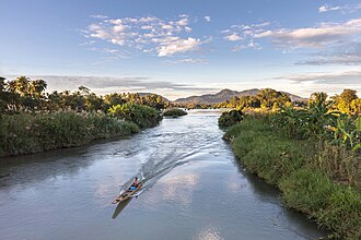
A boat floats on the Mekong in Laos.
: A boat floats on the Mekong in Laos.

Key Facts

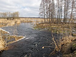
A small channel of water in the late fall or winter, surrounded by brown marsh-like vegetation
This marsh is a floodplain of the Narew in Poland.
  • Water Sources: Rivers are fed by precipitation, snowmelt, glacial melt, and aquifers.
  • Landscape Impact: Through erosion and sediment transport, rivers create canyons, valleys, islands, and deltas.
  • Human History: The first complex human civilizations emerged on fertile river floodplains.
  • Infrastructure: Dams are used globally for hydroelectric power, navigation, and drinking water reservoirs.
  • Extraterrestrial Evidence: Geological data suggests rivers once flowed on Mars for at least 100,000 years.

The Mechanics of River Systems

Source and Drainage Basins

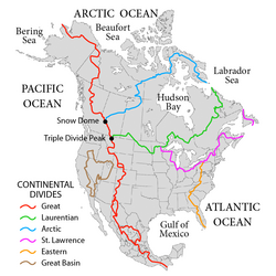
Rivers flow through channeled watercourses and merge at confluences to form drainage basins—areas where all surface water flows toward a common outlet. These basins are separated by drainage divides, which act as high-ground boundaries that direct upstream water into specific downhill streams.
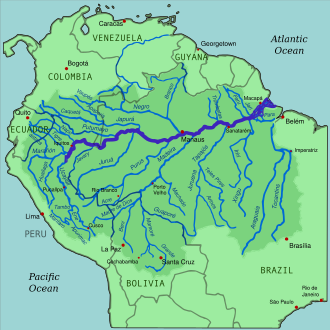
South America's Amazon River (dark blue) and the rivers which flow into it (medium blue). The darker green marks the Amazon's drainage basin or watershed
: South America's Amazon River (dark blue) and the rivers which flow into it (medium blue). The darker green marks the Amazon's drainage basin or watershed

The major drainage basins in North America
: The major drainage basins in North America

Flow and Landform Evolution

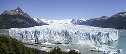
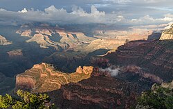
Rivers rarely travel in straight lines; instead, they meander, creating winding paths that can shift over time. As they flow, they perform erosion, carving rock into deep canyons and valleys. They also carry alluvium (sediment), which is deposited when the flow slows down, forming islands and deltas.
The end of a glacier, which looks like a wall of ice. Blue water filled with snow and ice is at the bottom of the cliff.
Melting toe of the Perito Moreno Glacier in Los Glaciares National Park, Argentina
: Melting toe of the Perito Moreno Glacier in Los Glaciares National Park, Argentina

The Grand Canyon was carved by the Colorado River.
: The Grand Canyon was carved by the Colorado River.

Variations in River Types

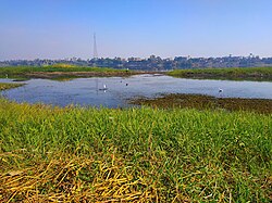
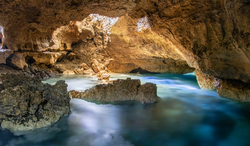
Not all rivers flow constantly. Non-perennial rivers may run dry if they exhaust their water supply or only flow during specific seasons. Some rivers are subterranean, flowing entirely underground within cave systems.
A photo showing a wide river with a variety of low wetland vegetation on the sides.
The Nile in Egypt is known for its fertile floodplains, which flood annually.
: The Nile in Egypt is known for its fertile floodplains, which flood annually.

A river of blue water flowing through a brown rock cave with sun peeking through.
The Blue Water Cave in Quezon, Philippines features an underground river.
: The Blue Water Cave in Quezon, Philippines features an underground river.

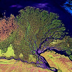
A satellite photo of a large river delta with many branching paths
The delta of the Lena River in Russia
: The delta of the Lena River in Russia

River Ecology and Classification

Rivers support diverse ecosystems where organisms like fish, aquatic plants, and insects play critical roles in predation and the processing of organic matter. Scientists use various models to understand these systems, such as the Strahler number to classify the hierarchy of tributaries.

A diagram of a possible river with the Strahler number of each tributary labeled.
: A diagram of a possible river with the Strahler number of each tributary labeled.

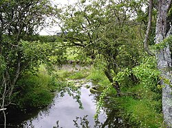
A few leafy trees around a small stream
The headwaters of the River Wey in England provide organic matter for organisms to process.
: The headwaters of the River Wey in England provide organic matter for organisms to process.

Human Interaction and Engineering

The Cradle of Civilization

Between 5,500 and 3,500 years ago, the first human civilizations were born on fertile floodplains. The Sumerians (Tigris-Euphrates), Ancient Egyptians (Nile), and the Indus Valley Civilization relied on these waters for survival, transportation, and the first organized irrigation systems.
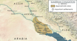
The Sumerian civilization was made possible by the floodplains of the Tigris and Euphrates rivers.
: The Sumerian civilization was made possible by the floodplains of the Tigris and Euphrates rivers.

Engineering the Flow

Humans have manipulated rivers for millennia. Early tools like the shadoof (a counterweight system for lifting water) and canals helped manage irrigation. Later, water wheels were used to grind grain and power textile mills, providing a massive leap in productivity before the advent of steam power.
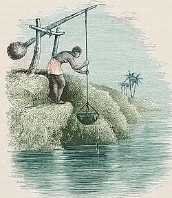
A drawing of a man raising water from a river with a bowl mounted on the end of a large rod with a counterweight on the other end
The counterweight system of the shadoof is an early example of the engineering of river water.
: The counterweight system of the shadoof is an early example of the engineering of river water.

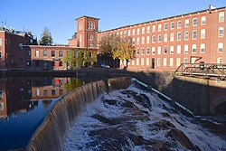
A red brick building built over a waterfall. The waterfall is a concrete dam structure.
The Cochecho mill in Dover, New Hampshire, United States was a textile mill powered by the pictured hydroelectric dam.
: The Cochecho mill in Dover, New Hampshire, United States was a textile mill powered by the pictured hydroelectric dam.

Modern Infrastructure and Dams

Today, dams are used to create reservoirs for drinking water, facilitate navigation, and generate hydroelectricity—a renewable energy source. While dam construction peaked in the 1970s, new projects are currently concentrated in Asia, particularly China and India.
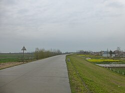
A road over a raised embankment of earth, a marsh on the left side, and some small farms on the other.
This levee protects the city of Honghu in the Hubei province of China from flooding.
: This levee protects the city of Honghu in the Hubei province of China from flooding.

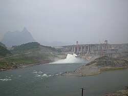
A grey dam in the distance spilling water from its center. Mountains are in the background.
The Na Hang Dam in Vietnam provides hydroelectric power.
: The Na Hang Dam in Vietnam provides hydroelectric power.

Trade, Culture, and Urbanization

Rivers like the Mississippi have served as vital shipping arteries for crops and goods. In cities like London (Thames), Paris (Seine), and New York (Hudson), rivers are central to cultural identity. Modern efforts now focus on restoring water quality and returning these urban waterways to the public for recreation.
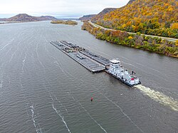
A small boat pushes a large flat barge down a wide river in the fall
The barge is one of the primary means of shipping goods on the Mississippi and other rivers.
: The barge is one of the primary means of shipping goods on the Mississippi and other rivers.

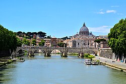
The Tiber river in Rome near the Ponte Sant'Angelo, Italy
: The Tiber river in Rome near the Ponte Sant'Angelo, Italy

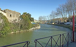
A small flat section of canal in the French countryside
The Canal du Midi was one of the first large canal projects in the world.
: The Canal du Midi was one of the first large canal projects in the world.

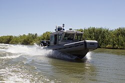
A medium-sized boat leaving a wake as it travels through murky waters
This U.S. Customs and Border Protection boat is attempting to prevent crossings of the Rio Grande river from Mexico into the U.S.
: This U.S. Customs and Border Protection boat is attempting to prevent crossings of the Rio Grande river from Mexico into the U.S.

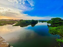
A slow moving river at sunset reflecting the sky
The Ogun River in Nigeria is sacred to the Yoruba.
: The Ogun River in Nigeria is sacred to the Yoruba.

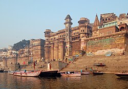
A castle built into the side of a river with a series of steps leading down into it.
The ghats along the Ganges river are the steps that allow people to bathe and release the ashes of the dead.[35]
: The ghats along the Ganges river are the steps that allow people to bathe and release the ashes of the dead.

Environmental Threats and Planetary Perspectives

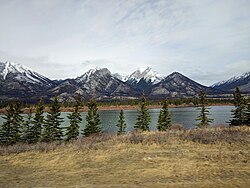
Rivers face significant modern threats. Diversion for agriculture can cause rivers to run dry before reaching the sea, as seen with the Colorado River. Additionally, retreating snow in mountain ranges threatens water levels across the Western United States.
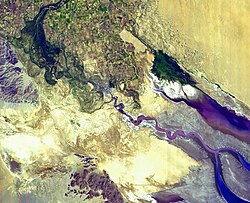
A satellite image of a river running dry.
The Colorado River now runs dry in the deserts of Mexico, rather than running to the sea, due to diversion of water for agricultural uses.[36]
: The Colorado River now runs dry in the deserts of Mexico, rather than running to the sea, due to diversion of water for agricultural uses.

Snow-capped mountains above a lake
Retreating snow in the Rocky Mountains is expected to reduce the level of waters in the Western United States.
: Retreating snow in the Rocky Mountains is expected to reduce the level of waters in the Western United States.

Rivers Beyond Earth

The study of rivers extends to other planets. On Mars, while liquid water is no longer present on the surface, geologists have found sedimentary rock and "bench and slope" landforms in the Hellas Planitia. These indicate that river networks and deltas existed for at least 100,000 years, driven by a prehistoric water cycle.
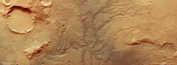
An orange moonscape, showing the rusty Mars soil. Impressions in the sand show where rivers once flowed, in a fractal-like form.
A dried out network of river valleys on Mars
: A dried out network of river valleys on Mars

Summary of River Characteristics and Human Uses
Category Key Examples/Features Primary Function/Impact
Landforms Deltas, Canyons, Meanders Landscape shaping via erosion and alluvium
Ancient Civilizations Nile, Indus, Tigris-Euphrates Agricultural foundation and urban growth
Infrastructure Dams, Canals, Levees Power generation, flood control, transport
Planetary Hellas Planitia (Mars) Evidence of ancient water cycles

Frequently Asked Questions

What is a drainage basin?

A drainage basin is an area of land where all surface water converges to a single point, such as a larger river, lake, or ocean. These areas are separated from other basins by high-ground boundaries called drainage divides.

How do rivers create deltas?

Deltas form when a river slows down as it enters a larger body of water, causing it to deposit the sediment (alluvium) it has been carrying. Over time, this buildup of material creates new landforms at the river's mouth.

Why were the first civilizations located near rivers?

Rivers provided three essential resources: a reliable source of fresh drinking water, fertile soil from annual flooding for agriculture, and a natural means of transportation for trade.

What is the purpose of a dam?

Dams are engineered to restrict water flow for several reasons: to generate hydroelectric power, to create reservoirs for a steady drinking water supply, and to raise water levels for easier boat navigation.

Did rivers ever exist on Mars?

Yes. Geological evidence, including sedimentary rock and river-carved channels in the Hellas Planitia, suggests that Mars had a water cycle with precipitation and flowing rivers for at least 100,000 years.