Rabbit Ears Pass: A High-Altitude Gateway in the Colorado Rockies
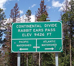
Located at the junction of the Rabbit Ears Range and the Park Range, Rabbit Ears Pass serves as a vital high mountain pass in the northern Rocky Mountains of Colorado. Straddling the Continental Divide—the hydrological divide that determines whether water flows toward the Atlantic or Pacific Oceans—this pass is a critical link for travelers moving between Steamboat Springs and Kremmling via U.S. Route 40.
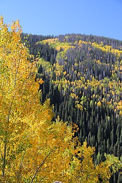
Reaching an elevation of 9,426 feet (2,873 meters), the pass is more than just a transit point; it is a landscape shaped by ancient volcanic activity and a hub for diverse outdoor recreation. Whether you are navigating the steep descents of the highway or exploring the subalpine forests, Rabbit Ears Pass offers a profound look at the natural beauty and geological complexity of the American West.
Geological Origins and Rabbit Ears Peak
The pass takes its name from the nearby Rabbit Ears Peak, a prominent landmark in Jackson County. This peak is characterized by its unique shape, featuring two large columns of basalt—a dark, fine-grained volcanic rock. These formations are remnants of a second volcanic episode, underlain by pink tuff and red, vesicular ash.
The geology of the area is particularly interesting to scientists due to the presence of volcanic breccia, a type of rock composed of broken fragments of minerals or rock cemented together by a fine-grained matrix. This large, stratified breccia pile at the peak, along with visible lava flow surfaces, provides a window into the region's volcanic history.
Key Facts
- Elevation: 9,426 feet (2,873 meters).
- Location: Junction of Jackson and Grand counties, Colorado.
- Major Route: U.S. Highway 40.
- Geological Feature: Rabbit Ears Peak (basalt formations and volcanic breccia).
- Climate: Ranges from semi-arid to humid with heavy seasonal snowpack.
- Primary Vegetation: Pine, spruce, and aspen trees.
Flora, Fauna, and the Subnivean Zone
The ecosystem of Rabbit Ears Pass is dominated by pine, spruce, and aspen trees, with sagebrush growing on the Niobrara, Pierre, and Coalmount formations. However, the forest has faced challenges from the spruce bark beetle (*Dendroctonus rufipennis*). These insects have caused significant declines in Engelmann spruce and lodgepole pine populations during periodic outbreaks, such as those recorded in the 1940s.
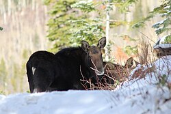
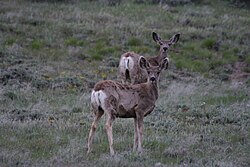
Despite these challenges, the pass remains a vital habitat for a wide variety of wildlife. Visitors may encounter elk, mule deer, moose, black bears, foxes, and snowshoe hares. In the winter, the deep snowpack creates a subnivean zone—a porous, air-filled space between the ground and the snow that acts as a thermal insulator for small animals like voles, lemmings, and shrews.
Outdoor Recreation and Seasonal Activities
Rabbit Ears Pass is a premier destination for year-round adventure, though activities are often divided by seasonal and regulatory boundaries to protect the environment.
Winter Sports
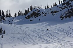
In the winter, the area is a hotspot for backcountry snowboarding, skiing, cross-country skiing, and snowshoeing. To manage the impact on wildlife and snow quality, the USDA Forest Service implements specific boundaries: non-motorized recreation is permitted west of the pass, while motorized recreation is permitted to the east. The snowmobile season typically begins once the unpacked snow depth reaches at least 30 cm (12 inches).
Summer Adventures
When the snow melts, the pass transforms into a playground for hikers and cyclists. Popular activities include:
- Trail Running: The "Run Rabbit Run" event features 50-mile and 100-mile distances.
- Road Biking: The pass is a legendary climb for cyclists, often featured in the USA Pro Cycling Tour.
- Mountain Biking: The "Ride the Divide" race traverses a 68.1-mile trail from Montana to Mexico, passing through this area.
- Camping and Hiking: Numerous trails and car camping spots are available throughout the Routt National Forest.
Navigating the Pass
Driving U.S. 40 over the pass requires attention, particularly on the western descent. While the summit area has a gently rolling character, the descent toward Steamboat Springs is the 28th steepest pass in Colorado, dropping 3,000 feet over seven miles with a 6.8% grade. A single runaway truck ramp is provided to assist drivers experiencing brake overheating.
| Feature | Details |
|---|---|
| Primary Highway | U.S. Route 40 |
| Highest Point | 9,426 ft |
| Mountain Range | Rocky Mountains (Park Range) |
| Management | U.S. Forest Service (Routt National Forest) |
| Steepest Descent | 6.8% toward Steamboat Springs |
Frequently Asked Questions
What is the significance of the Continental Divide at Rabbit Ears Pass?
The pass straddles the Continental Divide, which serves as the boundary between the upper basin of the Yampa River to the west and the North Park/upper North Platte River basin to the east.
How is motorized recreation managed in the winter?
To minimize impact on animal habitats and snowpack, motorized use is restricted to the eastern side of the pass, and the season only begins when snow depth reaches at least 30 cm.
Why is the descent toward Steamboat Springs considered dangerous?
It is the 28th steepest pass in Colorado, featuring a 6.8% grade and sharp curves due to a 3,000-foot drop over seven miles. A runaway truck ramp is available for safety.
What causes the unique shape of Rabbit Ears Peak?
The peak's shape is formed by two large columns of basalt rock resulting from a second volcanic episode.
Can I visit the old summit of the pass?
Yes, the old highway is now Grand County Road 199. You can access the old summit, which is marked by a stone monument, and reach the base of Rabbit Ears Peak via 4x4 trails.