Port Mercer: A Historic Canal Community in New Jersey
Nestled at the intersection of Lawrence Township, Princeton, and West Windsor Township in Mercer County, Port Mercer is an unincorporated community with a rich industrial and social legacy. Once a bustling hub of 19th-century commerce, this hamlet grew around the vital infrastructure of the Delaware and Raritan Canal, evolving from a sparsely populated meadow into a vibrant village before transitioning into a preserved historic site.
Key Facts
- Location: Intersection of Lawrence, Princeton, and West Windsor Townships, Mercer County, NJ.
- Economic Catalyst: The opening of the Delaware and Raritan Canal in 1834.
- Historic Status: Several buildings are listed on the National Register of Historic Places.
- Key Landmark: The Port Mercer Canal House, now a museum operated by the Lawrence Historical Society.
- Revolutionary Link: Marked by obelisks denoting George Washington's route during the Ten Crucial Days.
Early History and the Revolutionary War
Before its development as a commercial port, the area was largely isolated and sparsely populated, often referred to as the "Great Meadow." Its first significant historical marker occurred in 1777 during the American Revolution. As part of the Ten Crucial Days, George Washington and his troops marched through this region en route to the Battle of Princeton.
To commemorate this event, the Sons of the Revolution installed two obelisks along Quakerbridge Road in 1914, marking the path Washington took through the area.
The Rise of a Canal Town (1834–1892)
The isolation of Port Mercer ended abruptly in 1834 with the opening of the Delaware and Raritan Canal. This waterway, coupled with the arrival of the Camden and Amboy Railroad, transformed the local economy. A turning basin—a wide section of the canal allowing boats to turn around—became a critical economic outlet for local farms and provided residents of the nearby "Clarksville Basin" with essential goods like coal.
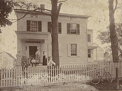
Infrastructure grew quickly to support this traffic. A swing bridge (a movable bridge that rotates to allow boat passage) was constructed in the 1830s. While the first bridge-tender's house was built between 1833 and 1834, a second Canal House was constructed in the 1840s due to a change in road alignment. This latter structure still stands today.
By 1849, the community was officially recognized as Port Mercer with the establishment of a post office run by John A. S. Crater. Crater became a central figure in the village's growth, operating a steam-powered sawmill, a coal yard, an ice house, a blacksmith shop, and a shoe store. He also built the Port Mercer Inn to serve travelers from the rail and canal lines.
Residential growth followed, with the construction of the Uhl-Keith, Uhl, Gordon, and Furman-Marchesi houses. Between 1840 and 1860, Crater also built the Gordon-Northrup House.
Community Life and Local Lore
The 19th-century community was characterized by a spirited relationship with the canal. Local residents sometimes intentionally delayed opening the swing bridge to profit from the resulting chaos; when mule tow lines became entangled and animals fell into the water, local boys would rescue them for a reward. Other residents entertained themselves by throwing coal at targets set up along the banks, while the general store served as the village's social heart for bartering and card games.
Economic Decline and Modern Preservation
The decline of Port Mercer began in 1863 when railroad commerce shifted toward the current route of the Northeast Corridor. The canal ceased to be profitable by 1892 and officially closed in 1933, eventually becoming a state park in 1974.
Despite the economic downturn, the community maintained a strong sense of neighborhood. While the general store was demolished in the 1950s, many historic homes survived as private residences. In 1973, several buildings were added to the National Register of Historic Places. The Lawrence Historical Society restored the Canal House in 1978, converting it into a museum that preserves the area's heritage.
| Period | Key Developments | Economic Driver |
|---|---|---|
| Pre-1834 | Sparsely populated "Great Meadow"; Washington's march (1777) | Subsistence Farming |
| 1834–1892 | Canal opening, swing bridge, Port Mercer Inn, and general store | Canal and Rail Commerce |
| 1892–1933 | Shift to Northeast Corridor rail; canal profitability ends | Local Agriculture/Horse Breeding |
| 1933–Present | Canal becomes state park; buildings listed on NRHP | Tourism and Preservation |
Frequently Asked Questions
What is the Port Mercer Canal House?
The Port Mercer Canal House is a historic building dating back to the 1840s that originally served as the residence for the operator of the canal's swing bridge. It is now a museum operated by the Lawrence Historical Society.
Why did Port Mercer decline economically?
The decline was primarily caused by the shift in railroad commerce to the Northeast Corridor route in 1863, which rendered the Delaware and Raritan Canal less profitable and eventually led to its closure in 1933.
What is the significance of the obelisks on Quakerbridge Road?
The two obelisks, installed in 1914, mark the route taken by George Washington and his troops in 1777 during the Ten Crucial Days leading up to the Battle of Princeton.
Which buildings in Port Mercer are historically significant?
Notable structures include the Port Mercer Canal House, the former Port Mercer Inn (now a private residence), and the Uhl-Keith, Uhl, Gordon, and Furman-Marchesi houses.
Where exactly is Port Mercer located?
Port Mercer is an unincorporated community located in Mercer County, New Jersey, at the point where the boundaries of Lawrence Township, Princeton, and West Windsor Township meet.