Delaware and Raritan Canal: A Historic New Jersey Waterway
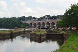
The Delaware and Raritan Canal (D&R Canal) is a historic waterway in central New Jersey that once served as a vital artery for American commerce. Built in the 1830s, this engineering feat connected the Delaware River to the Raritan River, providing an efficient route for transporting freight between Philadelphia and New York City. By bypassing the treacherous Atlantic coast and the long journey around Cape May, the canal significantly shortened the transit of goods, most notably anthracite coal from eastern Pennsylvania.
Today, the canal has transitioned from an industrial machine into a beloved recreational sanctuary, preserved as a state park and listed on the National Register of Historic Places.
Key Facts
- Construction Period: Built between 1830 and 1834.
- Total Length: Approximately 66 miles (106 km), consisting of a 44-mile main section and a 22-mile feeder canal.
- Primary Purpose: Transporting anthracite coal during the Industrial Revolution.
- Historic Status: Added to the National Register of Historic Places on May 11, 1973.
- Current Use: A New Jersey state park used for hiking, biking, kayaking, and fishing.
The History of the D&R Canal
Early Visions and Planning
The concept of linking the Raritan and Delaware Rivers dates back to the 1690s, when William Penn, the founder of Pennsylvania, first suggested the route to reduce the journey between Philadelphia and New York City by 100 miles. However, the project did not gain official momentum until 1816, when the New Jersey General Assembly commissioned John Rutherfurd and surveyor John Randel Jr. to map a practicable route.
Randel's survey concluded that the canal would require less than one-eighteenth of the water from local streams, ensuring that local mills would not be deprived of water flow. Despite these findings, political opposition delayed the project for over a decade.
Construction and the Industrial Boom
The New Jersey legislature finally chartered the canal on February 4, 1830. Construction was nearly halted due to a lack of funding until Robert F. Stockton pledged his family's personal fortune to ensure the project's completion. The canal was largely dug by hand, primarily by Irish immigrants, and was completed in 1834 at a cost of approximately $2,830,000.
In its early years, teams of mules towed canal boats along the banks. The canal reached its peak usage during the 1860s and 1870s, serving as a critical link for coal transport during the American Industrial Revolution. In 1872, the D&R Canal Company merged into the United New Jersey Railroad and Canal Company and was subsequently leased by the Pennsylvania Railroad.
Engineering and Route Details
The Canal System
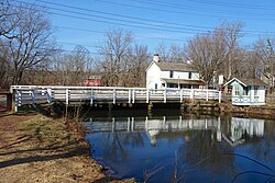
The system was divided into two primary components: the main canal and the feeder canal. The main section ran 44 miles from Bordentown on the Delaware River to New Brunswick on the Raritan. To maintain water levels, a 22-mile feeder canal stretched north from Trenton to Bulls Island, collecting water from higher elevations to supply the main channel.
| Section | Length | Width | Depth |
|---|---|---|---|
| Main Canal | 44 miles (71 km) | 75 feet (23 m) | 8 feet (2.4 m) |
| Feeder Canal | 22 miles (35 km) | 60 feet (18 m) | 6 feet (1.8 m) |
Locks and Spillways
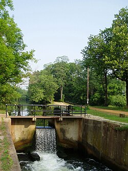
To manage changes in elevation, engineers installed locks (compartments with gates used to raise or lower boats). While many locks remain, most gates have been replaced by small dams or removed. Additionally, spillways were constructed to drain excess water during heavy flow; these are still visible today as dips in the towpath.
Evolution into a State Park
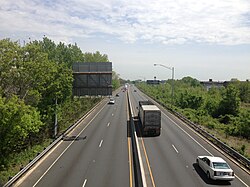
As railroads replaced canals for rapid transport, the D&R Canal's commercial importance declined, and it ceased operations in 1932. Over the following decades, portions of the canal were filled or piped underground to accommodate road projects, including the Trenton Freeway and Route 18.
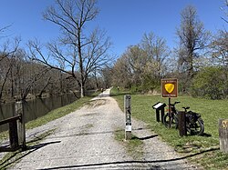
In 1974, the remaining system was designated a New Jersey state park. The former towpaths—once used by mules—now serve as graded trails for hiking, jogging, and horseback riding. The feeder canal, having previously been a railroad bed, is particularly popular for bicycling.
Some of the most scenic areas include the segment along Lake Carnegie in Princeton and the borders of the Colonial Park Arboretum and Gardens in East Millstone.
Local Folklore
The canal is also the subject of local legend. For 30 years, residents of Griggstown claimed to see a "ghost cow" along the Millstone River. This folklore persisted until November 23, 2002, when a live bull was discovered in a ditch and subsequently euthanized, providing a physical explanation for the sightings.
Frequently Asked Questions
What was the primary purpose of the D&R Canal?
The canal was primarily used to transport anthracite coal from eastern Pennsylvania to New York City, providing a more efficient and safer alternative to sailing around Cape May.
Who funded the construction of the canal?
While the state provided a charter and allocated stock, the project was nearly stalled by a lack of subscriptions until Robert F. Stockton pledged his family's personal fortune to complete the work.
How is the canal used today?
It is now a New Jersey state park used for recreation, including canoeing, kayaking, fishing, hiking, and bicycling along the historic towpaths.
What happened to the sections of the canal in Trenton and New Brunswick?
Some sections were filled for road and rail projects, while others were piped underground to allow for the construction of the Trenton Freeway and the Elmer Boyd Parkway Extension (Route 18).
What is a feeder canal?
A feeder canal is a secondary channel that collects water from higher elevations—in this case, from the Delaware River at Bulls Island—and feeds it into the main canal to maintain necessary water levels.