Polar Climates: Characteristics, Subtypes, and Global Distribution
Polar climates are defined by a persistent lack of warm summers, creating some of the most extreme environments on Earth. Covering more than 20% of the planet's surface, these regions are primarily located far from the equator. Because of their position near the poles, they experience dramatic seasonal shifts in daylight, with winter days being extremely short and summer days lasting for the entirety of the season or longer.
The defining characteristic of a polar climate is that every single month maintains an average temperature of less than 10 °C (50 °F). Depending on the specific region, this results in landscapes dominated by treeless tundras, massive glaciers, or permanent sheets of ice.
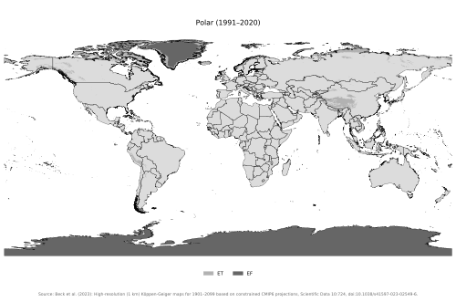
Key Facts
- Global Coverage: Polar climates occupy over 20% of the Earth's total area.
- Temperature Threshold: No month averages above 10 °C (50 °F).
- Coldest Record: Antarctica holds the record for the lowest naturally occurring temperature at −89.2 °C (−128.6 °F).
- Classification: Identified by the letter "E" in the Köppen climate classification system.
- Precipitation: Antarctica is technically a polar desert, averaging only 166 mm (6.5 in) of precipitation annually.
The Mechanics of Polar Cold
The extreme cold of the poles is primarily driven by solar geometry. Solar radiation hits the poles at a less direct angle than it does at the equator, reducing its intensity. Additionally, sunlight must travel through a thicker layer of the atmosphere to reach the ground in these regions.
![Solar radiation has a lower intensity in polar regions because the angle at which it hits the earth is not as direct as at the equator. Another effect is that sunlight has to go through more atmosphere to reach the ground.[1]](/images/84/c0/84c04ed7a10e6836f9e454c4829e10de7d99458cbd51bd4ea714bc1879f73ce7.webp)
Subtypes of Polar Climates
Within the Köppen system, polar climates are divided into two primary categories based on their warmest months.
Tundra Climate (ET)
A tundra climate is characterized by having at least one month where the average temperature rises above 0 °C (32 °F). While it is too cold for coniferous trees to grow, specialized vegetation like the arctic poppy can survive here.
Ice Cap Climate (EF)
In an ice cap climate, no month ever averages above 0 °C (32 °F). This prevents all plant growth and leads to the gradual accumulation of ice that eventually flows or slides across the landscape.
It is important to distinguish these from Alpine climates. While high-altitude mountain regions may mimic tundra or ice cap conditions, they are classified as Alpine because their cold temperatures are caused by elevation rather than latitude.
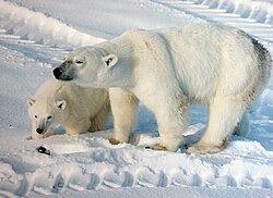
Global Distribution
The distribution of polar climates varies significantly between the Northern and Southern Hemispheres.
The Arctic Region
The Arctic consists of an ocean surrounded by landmasses, including Russia and Canada. This geography allows the ocean to moderate the climate; since seawater cannot drop below −2 °C (28 °F), the North Pole is not the coldest place in the Northern Hemisphere. January temperatures typically range from −40 to 0 °C, though they can drop below −50 °C. July temperatures range from −10 to 10 °C, with some land areas occasionally exceeding 30 °C.
![A map of the Arctic. The red line indicates the 10°C isotherm in July and the white area shows the average minimum extent of sea ice in summer as of 1975.[3]](/images/f2/f7/f2f75dee438dec4015ea7f505e172406315d1c1bc0c40b722b39ef88f2412209.webp)
Antarctica and the Southern Hemisphere
Antarctica is the only continent where the ice cap climate is predominant. It is significantly colder and drier than the Arctic. Outside of the main continent, tundra climates are found in the South Shetland Islands, the Falkland Islands, and the southernmost tip of Argentina in Tierra del Fuego.
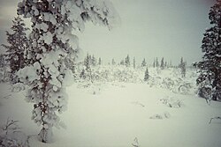
High-Altitude Polar Climates
Many mountain summits exhibit polar climates regardless of their latitude. Tundra climates are found in the Alps, the Caucasus, and the Rocky Mountains. Ice cap climates occur at extreme elevations in the Himalayas, the Andes, the Alaska Range, the Karakoram, the Hindu Kush, the Pamir, and the Tian Shan mountains. In the Cascade Range, only the summit of Mount Rainier maintains an ice cap climate.
Quantifying the Polar Boundary
Scientists have used different methods to determine where a polar climate begins:
- Wladimir Köppen: Used the 10 °C (50 °F) summer isotherm (a line connecting points of equal temperature) to mark the tree line, noting that forests cannot survive where the warmest month is below this threshold.
- Otto Nordenskjöld: Proposed a formula (W = 9 − 0.1 C) that considers both the warmest (W) and coldest (C) months to determine tree survival.
- Holdridge: Introduced biotemperature, which ignores temperatures below 0 °C or above 30 °C since plants are dormant during those times. A mean biotemperature between 1.5 and 3 °C is classified as subpolar or alpine.
| Feature | Tundra (ET) | Ice Cap (EF) |
|---|---|---|
| Warmest Month Avg | Above 0 °C (32 °F) but below 10 °C | Below 0 °C (32 °F) |
| Vegetation | Specialized plants (e.g., arctic poppy) | None |
| Typical Landscape | Treeless plains, mosses, lichens | Permanent ice sheets, glaciers |
| Primary Locations | Northern Canada, Siberia, Coastal Greenland | Antarctica, Interior Greenland |
Frequently Asked Questions
What is the difference between a tundra and an ice cap climate?
The primary difference is the temperature of the warmest month. A tundra climate has at least one month that averages above 0 °C (32 °F), allowing some plant life to grow. An ice cap climate never averages above 0 °C, meaning no plants can survive.
Why is Antarctica colder than the Arctic?
The Arctic is an ocean surrounded by land, and the relatively warmer ocean water (which stays above −2 °C) moderates the temperature. Antarctica is a landmass surrounded by ocean, and its high elevation and isolation make it much colder.
Can polar climates exist near the equator?
Yes, but only at very high elevations. These are referred to as Alpine climates. The summits of high mountains in the Andes or Himalayas can exhibit tundra or ice cap characteristics despite being at lower latitudes.
What is a polar desert?
A polar desert is a region with extremely low precipitation. Antarctica is the most prominent example, averaging only 166 millimetres (6.5 in) of precipitation per year because weather fronts rarely reach the interior of the continent.
How does biotemperature differ from average temperature?
Biotemperature only counts temperatures between 0 °C and 30 °C. This is because plant life is generally dormant when it is freezing or excessively hot, so those temperatures do not contribute to biological growth.