New Orleans Hurricane Preparedness and Vulnerability
New Orleans has faced a constant struggle against the elements since its earliest settlement. The city's unique geography—built on a marsh and surrounded by the Mississippi River, Lake Pontchartrain to the north, and Lake Borgne to the east—makes it naturally susceptible to flooding. Today, nearly half of the modern city sits below sea level, creating a precarious environment where hurricane preparedness is not just a precaution, but a necessity for survival.
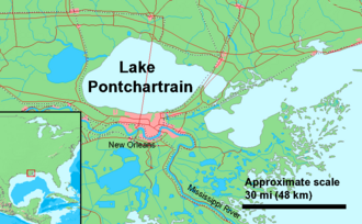
Key Facts
- Geography: Nearly 50% of the city is located below sea level.
- Historical Impact: Devastating storms like the 1856 Last Island Hurricane and the 1893 Chenière Caminada hurricane set early precedents for disaster.
- Infrastructure: The city relies on a complex system of levees and drainage pumps to manage water levels.
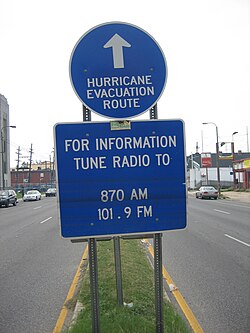
- Evacuation: Contraflow lanes (reversing highway traffic to allow all lanes to flow away from the city) were first fully implemented during Hurricane Ivan in 2004.
- Environmental Risk: Silt blockage from river levees and resource extraction have contributed to the sinking of the Louisiana coast.
A History of Storms and Infrastructure
The 19th and Early 20th Centuries
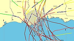
The 1800s were marked by catastrophic events. The 1856 Last Island Hurricane destroyed nearly every building on Last Island, killing over 200 of the 400 residents and leaving the land fragmented and uninhabited. In New Orleans, this storm dropped 13 inches (330 mm) of rain. Later, the 1893 Chenière Caminada hurricane also caused widespread devastation.
By 1915, the "Great Storm" brought significant wind damage. While improved drainage pumping limited the scope of flooding, Lake Pontchartrain rose to record levels, overtopping back levees and prompting the Sewage and Water Board to recommend taller barriers.
Late 20th Century Engineering Struggles
In 1971, the US Army Corps of Engineers began constructing the Lake Pontchartrain Hurricane Barrier, featuring flood gates similar to those used in the Netherlands. However, construction halted in 1977 following a lawsuit by the environmental group Save Our Wetlands, which argued the environmental impact statement was deficient. By 1985, the plan was scrapped in favor of reinforcing existing levees.
Predicting the Catastrophe
Warnings and Simulations
In 2001, FEMA identified a major hurricane hitting New Orleans as one of the three most serious threats to the United States. Media reports from the Houston Chronicle and The Times Picayune echoed these concerns, predicting that a severe storm could drown the city under 20 feet of water, leaving hundreds of thousands homeless and ruining the local economy.
To prepare, officials created "Hurricane Pam" in 2004—a hypothetical Category 3 storm with 120 mph winds. The simulation predicted that such a storm could displace over one million people, damage 600,000 buildings, and result in 60,000 deaths, highlighting critical failures in transportation and evacuation planning.
The Path to Katrina
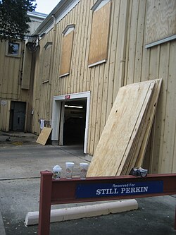
Hurricane Ivan in 2004 triggered the city's largest evacuation to date, with over 600,000 people fleeing Greater New Orleans. This event served as a trial for the contraflow plan, which was later used more smoothly during the 2005 season. Shortly before Hurricane Katrina, Hurricane Cindy (July 2005) caused the city's largest blackout since 1965, serving as a wake-up call to a population that had become blasé about hurricane threats.
The Levee Debate and Coastal Erosion
Funding and Design Failures
The vulnerability of New Orleans is tied closely to funding and engineering. In 2004, the Corps of Engineers requested $4 million for a study to protect the city from Category 4 or 5 hurricanes, but Congress tabled the proposal due to budgetary concerns related to the Iraq War. While some officials estimated a full protection project would cost $1 billion and take 20 years, others suggested a 1-in-500-year levee system could cost as much as $30 billion.
Following the disasters of 2005, the Corps of Engineers planned to spend $6 billion by 2010 to ensure the city would likely be flooded only once every 100 years. This remains far below the Dutch standard, which protects against 1-in-10,000-year floods.
The Sinking Coast
Human intervention has exacerbated the risk. By leveeing the Mississippi River, the Corps of Engineers cut off the flow of silt (sediment), which is essential for building the delta and wetlands. This, combined with the weight of urban infrastructure and the extraction of oil and gas, has caused the land to sink. To combat this, the "Coast 2050" plan was proposed—a $14 billion initiative to rebuild wetlands over 30 years.
Summary of Hurricane Protection and Risks
| Standard/Plan | Protection Level | Estimated Cost/Detail |
|---|---|---|
| Dutch System | 1-in-10,000-year flood | Global Gold Standard |
| Proposed USACE (2006) | 1-in-100-year flood | $6 Billion |
| Proposed High-Level | 1-in-500-year flood | $30 Billion |
| Coast 2050 | Wetland Restoration | $14 Billion |
Frequently Asked Questions
Why is New Orleans so vulnerable to hurricanes?
The city is built on a marsh, is surrounded by water on three sides, and nearly half of its area sits below sea level, making it naturally prone to flooding and storm surges.
What is contraflow and why is it used?
Contraflow is an evacuation strategy where all lanes of a highway are directed away from the city to maximize the number of vehicles that can exit the area quickly during an emergency.
What was "Hurricane Pam"?
Hurricane Pam was a fictional, hypothetical Category 3 hurricane used in a 2004 disaster simulation to identify weaknesses in the evacuation and emergency response plans for Southeastern Louisiana.
How did the Mississippi River levees contribute to the city's risk?
While levees protect the city from river flooding, they prevent silt from reaching the delta. This stops the natural building of land, contributing to the sinking of the coast and the loss of protective wetlands.
What is the Coast 2050 plan?
Coast 2050 is a $14 billion proposal aimed at rebuilding Louisiana's wetlands over a 30-year period, funded largely by oil and gas royalties, to provide a natural buffer against storm surges.