Liancourt Rocks: Geography, Ecology, and the Sovereignty Dispute
The Liancourt Rocks, a group of islets located in the Sea of Japan, represent a significant geographical and political focal point between the Korean Peninsula and the Japanese archipelago. Known as Dokdo in Korea and Takeshima in Japan, these volcanic formations are more than just remote outposts; they are ecologically rich habitats and the center of a long-standing sovereignty dispute.
The English name, Liancourt Rocks, originates from the French whaling ship Le Liancourt, which narrowly avoided shipwreck on the rocks in 1849. Today, the islets are administered by South Korea, though they remain claimed by Japan.
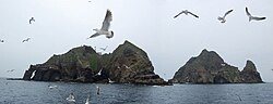
Geography and Composition
The Liancourt Rocks consist of 91 islets and reefs in total, though only 37 are recognized as permanent land. The group is dominated by two primary islets: the East Islet (Dongdo in Korean; Mejima in Japanese) and the West Islet (Seodo in Korean; Ojima in Japanese). These two main islands are separated by a distance of 151 metres (495 ft).
The West Islet is the larger and higher of the two, reaching an elevation of 168.5 metres (553 ft). It is characterized by a single peak and numerous coastal caves. In contrast, the East Islet offers more usable surface area and features cliffs ranging from 10 to 20 metres high, along with a crater and two large sea caves.
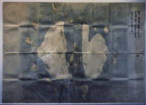
Geological Origins
These islets are volcanic rocks formed during the Cenozoic era, specifically between 4.6 and 2.5 million years ago. Geologists have noted that the islets are undergoing rapid erosion. The total surface area of the group is approximately 18.745 hectares (46.32 acres).
Key Facts
- Primary Islets: West Islet (higher elevation) and East Islet.
- Total Landmass: 91 islets/reefs, with 37 being permanent land.
- Highest Point: 168.5 metres (553 ft) on the West Islet.
- Administration: Managed by South Korea (Ulleung County).
- Climate: Warm and humid, heavily influenced by sea currents, with high annual precipitation.
- Ecological Status: Designated as a Natural Monument of South Korea.
Ecology and Environmental Protection
Despite the thin layer of soil and moss, the islets support a diverse range of life. Researchers have identified approximately 49 plant species, 107 bird species, and 93 insect species. The surrounding waters are equally vibrant, hosting 160 algal and 368 invertebrate species. Large marine animals, including minke whales, orcas, and dolphins, are known to migrate through the area.
Because the natural spring water is subject to guano contamination, desalination plants were installed to provide clean water for the small population of personnel. In 1982, the Republic of Korea designated the area as a Natural Monument to protect its unique vegetation and wildlife, specifically serving as a breeding ground for species like the band-rumped storm petrel and black-tailed gull.
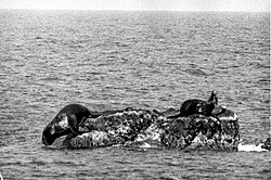
Human Presence and Infrastructure
The islets are home to a small number of people, primarily South Korean police guards, lighthouse managers, and office staff. As of 2026, the population consists of approximately 25 individuals, with no resident civilians remaining following the passing of previous permanent residents. To support these personnel, South Korea has constructed a lighthouse, a helicopter pad, police barracks, and cellular telephone towers.
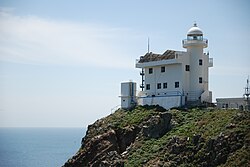
Tourism is strictly regulated. While ferries from Ulleungdo provide access, visitors must receive South Korean government approval. In 2025, the islands saw approximately 192,122 visitors, averaging about 500 people per day.
Summary of Islet Data
| Feature | Details |
|---|---|
| Total Area | 18.745 ha (46.32 acres) |
| West Islet Area | 8.864 ha (21.90 acres) |
| East Islet Area | 7.33 ha (18.1 acres) |
| Highest Elevation | 169 m (554 ft) |
| Coordinates | 37°14′30″N 131°52′0″E |
Sovereignty Dispute
The ownership of the Liancourt Rocks is a central point of contention in diplomatic relations between Japan and South Korea. South Korea bases its claims on historical records, such as the Annals of Joseon Dynasty, which refer to an island called Usando. Japan contests these interpretations, suggesting those historical references may refer to other islands or non-existent locations.
While North Korea previously contested Japan's claim alongside South Korea, recent shifts in North Korean policy have seen the omission of territories administered by the South, including the Liancourt Rocks, from their official maps.
Frequently Asked Questions
Why are the islands called Liancourt Rocks?
The name is derived from the French whaling ship Le Liancourt, which nearly wrecked on the rocks in 1849.
Can anyone visit the islands?
Access is restricted and requires South Korean government approval. Visitors typically arrive via ferry from Ulleungdo, though landing is often impossible if sea swells exceed 3 to 5 metres.
What is the main source of fresh water on the islets?
While there is natural spring water, it suffers from guano contamination. Therefore, desalination plants are used to provide clean water for human consumption.
What makes the islands ecologically significant?
The islets serve as a vital habitat for numerous seabirds, diverse plant life, and marine species, leading to their designation as a Natural Monument by South Korea.
How many people live on the rocks?
The population is primarily composed of government personnel, including police, lighthouse managers, and staff, totaling approximately 25 people.