Khyber Pass: The Strategic Gateway Between Central Asia and India
The Khyber Pass is one of the most renowned mountain passes in the world, serving as a critical link between the town of Landi Kotal and the Valley of Peshawar at Jamrud. Located in the Khyber District of Pakistan's Khyber Pakhtunkhwa province, this rugged corridor traverses the White Mountains (Spīn Ghar) along the international border with Afghanistan.
Historically, the pass has functioned as far more than a simple geographic crossing. As a vital segment of the ancient Silk Road—the network of trade routes connecting East Asia to Europe—it has been a primary artery for commerce and a strategic military choke point for the empires that sought to control the flow of goods and armies between Central Asia and the Indian subcontinent.
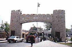
Key Facts
- Location: Khyber District, Khyber Pakhtunkhwa, Pakistan, bordering Afghanistan.
- Summit Elevation: 1,070 meters (3,510 feet).
- Primary Connection: Links Landi Kotal to the Valley of Peshawar.
- Key Infrastructure: Traversed by the N-5 National Highway and the (currently closed) Khyber Pass Railway.
- Historical Significance: A major route for the Silk Road and numerous ancient military invasions.
Geography and Demography
The pass follows the path of Asian Highway 1 (AH1). Its summit at Landi Kotal is situated 5 km (3 mi) inside Pakistani territory. From there, it descends 460 m (1,510 ft) into the Peshawar Valley at Jamrud, located approximately 30 km (19 mi) from the Afghan border. The main section of the pass spans 25 miles (40 km) from Jamrud to Landi Kotal, with an additional 8-mile (13 km) stretch extending west toward Lōya Daka in Afghanistan.
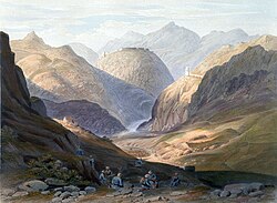
The region is defined by its tribal landscape. To the north lie the territories of the Mullagori and Shalmani tribes, while Afridi Tirah lies to the south. The villages within the pass are inhabited by Afridi clansmen. For centuries, Pashtun clans—specifically the Afridis and the Afghan Shinwari—have viewed the pass as their own preserve, historically levying tolls on travelers in exchange for safe passage.
Ancient and Islamic History
The Khyber Pass has been the gateway for countless invasions of the Indian subcontinent. Ancient military expeditions were launched through the pass by the Achaemenid and Sassanid empires, including rulers such as Darius I, Ardashir I, Shapur I, and Anushirvan. Later, Mongol leaders like Duwa, Qutlugh Khwaja, and Kebek utilized the route, as did nomadic groups such as the Saka, Yuezhi, and White Huns.
Beyond warfare, the pass facilitated the spread of Greek influence into India and the expansion of Buddhism in the opposite direction. It became a hub for the trade of luxury goods, including silk, jade, and rhubarb from China, and ivory, pepper, and textiles from India. This commerce established Gandhara (modern-day Pakistan) as a regional center connecting Bagram in Afghanistan to Taxila in India.
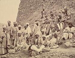
During the Islamic period, the pass remained a primary route for conquerors. Rulers such as Mahmud Ghaznavi, Muhammad of Ghor, Timur, Babur, and Nader Shah used the Khyber and adjacent passes to enter the subcontinent. While the Mughals attempted to maintain control, they faced persistent resistance from local tribes. Ahmad Shah Durrani was the last major Islamic conqueror to successfully cross the pass.
British Colonial Rule and Infrastructure
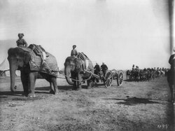
In the 19th century, the British East India Company sought to secure the pass to prevent Russian expansion, a geopolitical struggle known as the Great Game. Control of the region shifted between the British, Afghans, and Sikhs. In 1837, the Sikhs under Ranjit Singh captured the pass, and General Hari Singh Nalwa constructed the Jamrud Fort to secure the area.
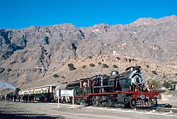
Following the Second Anglo-Afghan War in 1880, the British established control by paying local tribes to ensure the security of the route. They invested heavily in infrastructure, including telegraph lines and roads. In 1925, the British Indian government opened the Khyber Pass Railway, a heavily engineered line running from Jamrud to the Afghan border.
During World War II, the British installed concrete "dragon's teeth" (anti-tank fortifications) on the valley floor, fearing a potential Axis power invasion of India.
Modern Era and Strategic Importance
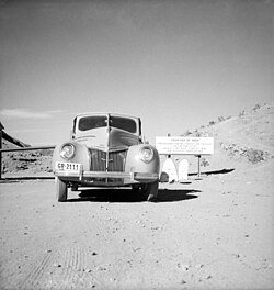
After the 1947 partition of India, the Khyber Pass became part of Pakistan. In the mid-to-late 20th century, it became a popular stop on the "hippie trail" for Western and Japanese travelers journeying from Kabul to Peshawar.
In the 21st century, the pass regained global strategic prominence during the War in Afghanistan. Starting in 2001, it served as the primary supply route for NATO and US forces, handling nearly 80% of all road-transported military armament and food. However, the route became increasingly unstable due to conflicts with Taliban guerrillas. In 2009, Pakistan sealed the bridge as part of a military offensive in Jamrud.
Tensions peaked in 2010 when a NATO helicopter attack killed three Pakistani soldiers, leading Pakistan to temporarily close the pass to NATO supply trucks. This instability eventually forced the US and NATO to diversify their supply routes through Central Asian countries like Turkmenistan, Uzbekistan, and Tajikistan.
Summary of Khyber Pass Characteristics
| Feature | Details |
|---|---|
| Summit Elevation | 1,070 m (3,510 ft) |
| Total Length | Approx. 25 miles (40 km) from Jamrud to Landi Kotal |
| Mountain Range | White Mountains (Spin Ghar) |
| Key Towns | Landi Kotal (Pakistan), Jamrud (Pakistan), Lōya Daka (Afghanistan) |
| Primary Transport | N-5 National Highway, Khyber Pass Railway (closed) |
Cultural References
The fame of the Khyber Pass has led to its name being adopted globally, from roads in Scotland, Ireland, and New Zealand to a pub in Philadelphia. It is frequently referenced in literature and art, appearing in the poems of Rudyard Kipling and songs by Pink Floyd, Vampire Weekend, and Tom Cochrane. It has also been featured in films such as The Man Who Would Be King, Carry On Up the Khyber, and Ghosted.
Frequently Asked Questions
What is the primary purpose of the Khyber Pass today?
While historically a trade and military route, it currently serves as a border crossing and transport link between Pakistan and Afghanistan, though its stability varies based on the regional security situation.
Which tribes historically controlled the pass?
The Pashtun clans, most notably the Afridis and the Afghan Shinwari, have historically regarded the pass as their preserve and collected tolls from travelers.
What was the "Khyber Pass Railway"?
It was a strategic railway built by the government of British India that opened in 1925, connecting Jamrud to the Afghan border near Landi Kotal. It is currently closed.
How did the pass support NATO forces?
From 2001 until roughly 2007, the Khyber Pass was the primary logistics artery for the War in Afghanistan, transporting approximately 80% of NATO and US road supplies.
What are "Khyber Pass copies"?
This term refers to a local counterfeit arms industry where blacksmiths use local steel to create copies of various weapons, which are often sought after by gun collectors.