Intertropical Convergence Zone: The Engine of Tropical Weather
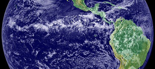
The Intertropical Convergence Zone (ITCZ) is a massive belt of low pressure that encircles the Earth near the equator. Known to sailors for centuries as the doldrums or the calms, this region is characterized by stagnant winds and frequent, intense thunderstorms. It serves as the primary meeting point where the northeast trade winds from the Northern Hemisphere and the southeast trade winds from the Southern Hemisphere converge.
While it often aligns with the geographic equator, the ITCZ is dynamic, shifting its position based on the thermal equator—the line where average surface temperatures are highest. This movement dictates the wet and dry seasons for millions of people living in tropical regions.
Key Facts
- Formation: Created by the convergence of northeast and southeast trade winds.
- Weather: Characterized by convective activity, heavy rainfall, and thunderstorms.
- Movement: Shifts north and south seasonally, following the sun's peak heating.
- Nautical Impact: Historically known as the doldrums due to windless conditions that could strand sailing ships.
- Cyclone Role: Provides the necessary low-level vorticity (horizontal wind shear) for tropical cyclone formation.
The Meteorology of the ITCZ
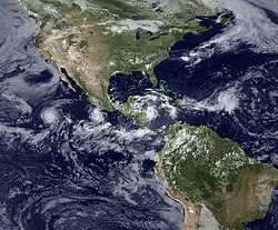
The ITCZ is essentially the ascending branch of the Hadley cell, a global atmospheric circulation pattern. Solar heating at the equator causes air to rise rapidly, creating a zone of low pressure that draws in the surrounding trade winds. As this moist air ascends, it cools and condenses, resulting in the characteristic band of clouds and thunderstorms visible from space.
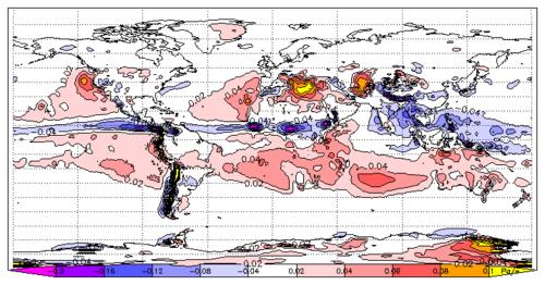
The behavior of these winds is influenced by the Coriolis effect—the deflection of moving objects caused by Earth's rotation. For example, when the ITCZ moves north of the equator, the southeast trade winds cross the equator and shift to a southwest direction.
Seasonal Variability and Land vs. Ocean
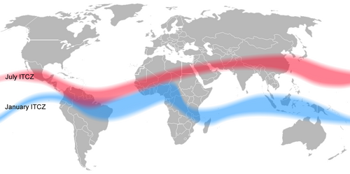
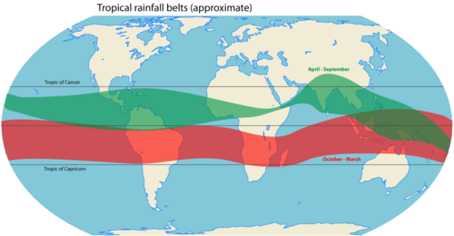
The ITCZ does not stay fixed. It migrates seasonally, moving farther from the equator during the Northern Hemisphere summer than during the Southern summer, largely due to the distribution of landmasses. Because land heats and cools faster than the ocean, this migration is more pronounced over continents.
Interestingly, while the ITCZ and maximum rainfall usually overlap over oceans, they can become decoupled over land. On continents, rainfall is influenced by additional factors such as local atmospheric jets, terrain, moisture recycling, and land cover (albedo).
![Seasonal variability of the Intertropical Convergence Zone (ITCZ), Congo air boundary (CAB), tropical rainbelt, and surface winds over Africa (adapted from Dezfuli 2017 with modification). This schematic shows that the ITCZ and the region of maximum rainfall can be decoupled over the continents.[1]](/images/fc/ee/fcee4fa0b087691daec80d2a23cf3abbb4c80e82357d21911da52d7d6b0cfc82.png)
Regional Variations and the South Pacific
Not all parts of the convergence zone behave identically. The South Pacific Convergence Zone (SPCZ) is a significant variation, extending from the west Pacific warm pool southeast toward French Polynesia. Unlike other sections of the ITCZ, the SPCZ is less dependent on heating from nearby landmasses.
In the eastern tropical Pacific and Atlantic, the Southern ITCZ (SITCZ) appears during the Southern Hemisphere fall. However, this zone can vanish during an El Niño event, when the usual upwelling of cold water off the South American coast disappears, altering sea surface temperatures.
Impact on Weather and Aviation
The ITCZ is the primary driver of tropical seasonality. Rather than the temperature-based seasons found in higher latitudes, equatorial nations experience wet and dry seasons based on the ITCZ's position. Long-term shifts in this zone can lead to catastrophic flooding or severe droughts, such as those seen in the Sahel during the 1980s.
Tropical Cyclone Formation
The ITCZ is critical for tropical cyclogenesis (the birth of cyclones). It provides horizontal wind shear—a change in wind speed and direction—which creates the low-level vorticity required for a storm to begin spinning. As the ITCZ moves into subtropical latitudes during summer, the increasing Coriolis force makes it easier for these disturbances to develop into full-scale hurricanes or typhoons.
Hazards: From Sailing Ships to Modern Jets
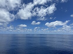
Historically, the doldrums were a place of peril for sailing ships, where a lack of wind could leave a crew stranded for weeks in oppressive heat.
In modern times, the danger has shifted to the skies. The ITCZ's massive convective cells can produce severe weather. A notable tragedy occurred in 2009 with Air France Flight 447, which crashed after encountering large ITCZ thunderstorms that caused ice to form on airspeed sensors, leading to a fatal series of errors.
Climate Change and the ITCZ
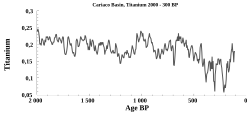
Paleoclimate data, such as titanium concentrations in the Cariaco Basin, show that the ITCZ has shifted significantly throughout Earth's history in response to global climate changes.
Recent observations and the IPCC Sixth Assessment Report suggest that anthropogenic climate change may be causing the ITCZ to narrow and intensify. This means precipitation becomes more concentrated in the core of the zone while the edges become drier. While global displacement of the ITCZ is still debated among scientists, some models (CMIP6) suggest regional shifts, including a northward move over the Indian Ocean and a southward move over the eastern Pacific and Atlantic.
| Feature | Description | Impact/Effect |
|---|---|---|
| Wind Pattern | Convergence of NE and SE trade winds | Creates the "doldrums" (calm winds) |
| Atmospheric Motion | Ascending branch of Hadley cell | Heavy rainfall and thunderstorms |
| Seasonal Shift | Follows the thermal equator | Determines tropical wet/dry seasons |
| Cyclone Role | Provides horizontal wind shear | Essential for tropical cyclogenesis |
| Climate Trend | Narrowing and intensification | Sharper contrast between wet core and dry edges |
Frequently Asked Questions
What exactly are the doldrums?
The doldrums are the regions within the ITCZ where the air is primarily rising vertically rather than blowing horizontally. This results in very light or non-existent winds, which historically made it difficult for sailing ships to navigate.
How does the ITCZ contribute to hurricanes?
The ITCZ provides the necessary low-level vorticity and wind shear. When the zone migrates away from the equator, the Coriolis effect becomes strong enough to turn these thunderstorm clusters into rotating tropical cyclones.
Does the ITCZ always stay at the equator?
No. It shifts north and south throughout the year, following the sun's peak heating (the thermal equator). This migration is more pronounced over land than over the ocean.
How is climate change affecting the ITCZ?
Evidence suggests the ITCZ is becoming narrower and more intense, meaning the central belt receives more rain while the surrounding fringes become drier. Some regional shifts in position are also being observed.
What is the difference between the ITCZ and a monsoon trough?
While similar, a monsoon trough occurs when the ITCZ merges with a larger monsoonal circulation system, a term more frequently used in Asia and Australia.