Eastern Washington: A Region of Diverse Landscapes and Contrasts
Located east of the Cascade Range, Eastern Washington is a vast region defined by its dramatic geography, agricultural productivity, and a climate that stands in stark contrast to the rainy coastlines of the west. Known by various names including the Eastside, the Columbia Basin, and the Inland Empire (a term that also encompasses the Idaho Panhandle), this region serves as the metropolitan and agricultural heart of the state's interior.
From the fertile rolling hills of the Palouse to the semi-desert environments of the Channeled Scablands, Eastern Washington offers a unique blend of urban centers and wild, protected landscapes.
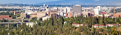
Key Facts
- Total Area: 46,620 square miles.
- Population: 1,667,593 (2020 Census).
- Highest Point: Mount Adams at 12,276 feet.
- Lowest Point: Columbia River at White Salmon (79 feet).
- Major Hubs: Spokane, the Tri-Cities (Kennewick, Pasco, and Richland), and Yakima.
- Key Features: Grand Coulee Dam, Hanford Nuclear Reservation, and the Yakima Valley.
Geography and Regional Nomenclature
Eastern Washington is characterized by its diverse terrain. While much of the region is dominated by the Columbia Basin, it also includes the high-altitude peaks of the Okanogan-Wenatchee National Forest and the rich soils of the Palouse. Residents often refer to the area as "The 509," a nod to the local area code.
The region is divided into several counties, including Adams, Asotin, Benton, Chelan, Columbia, Douglas, Ferry, Franklin, Garfield, Grant, Kittitas, Klickitat, Lincoln, Okanogan, Pend Oreille, Spokane, Stevens, Walla Walla, Whitman, and Yakima. Some definitions also include portions of Skamania County located east of the Cascade ridge line.
Protected Areas and Nature
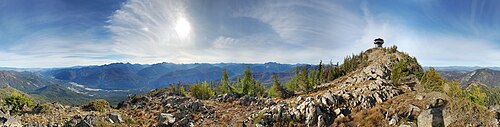
The region is home to numerous national forests and wildlife refuges, ensuring the preservation of its unique ecosystems. Notable protected areas include:
- National Forests: Colville, Okanogan–Wenatchee, and portions of the Idaho Panhandle, Kaniksu, and Umatilla forests.
- Wilderness Areas: Juniper Dunes, Salmo-Priest, and parts of the Wenaha-Tucannon Wilderness.
- Wildlife Refuges: Columbia, Conboy Lake, Little Pend Oreille, McNary, Saddle Mountain, Toppenish, and Turnbull.
- Monuments: Hanford Reach National Monument and Lake Roosevelt National Recreation Area.
Climate and the Rainshadow Effect
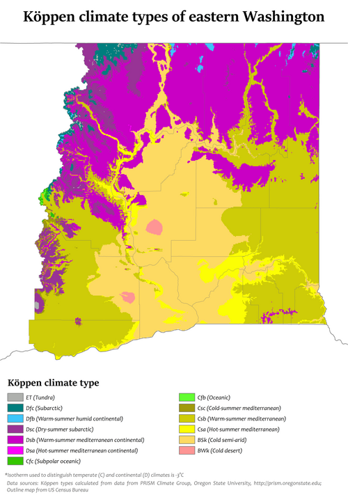
The most defining characteristic of Eastern Washington is its climate. The region experiences a rainshadow—a meteorological phenomenon where the Cascade Mountains block moisture-rich air from the Pacific Ocean, leaving the eastern side significantly drier than the west.
Because it is further from the moderating influence of the sea, Eastern Washington sees more extreme temperature swings, with hotter summers and colder winters. Unlike Western Washington, where snowfall is infrequent, most eastern communities experience significant yearly snowfall. Generally, lower elevations, such as Richland, are hotter and drier than higher-elevation cities like Spokane.
Comparative Climate Data
| Metric | Tri-Cities (Average) | Spokane (Average) |
|---|---|---|
| Annual Precipitation | 7.24 inches | 16.81 inches |
| Mean Maximum Temp (Year) | 106.4°F | 101.9°F |
| Mean Minimum Temp (Year) | 3.4°F | -6.4°F |
| Record High | 115°F | 112°F |
| Record Low | -27°F | -30°F |
Population and Education
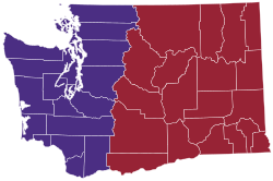
While Eastern Washington covers roughly twice the land area of Western Washington, it holds only about one-fourth of the state's population. As of 2020, the population was 1,667,593, a figure comparable to the population of West Virginia. Politically, the region is a Republican stronghold, with the exception of Whitman County, which is influenced by its status as a college town.
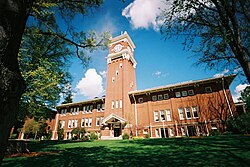
The region is a significant hub for higher education, hosting three of the state's five public universities: Central Washington University, Eastern Washington University, and Washington State University.
Academic and Research Institutions
- Public Colleges: Big Bend, Columbia Basin, Spokane Community College, Spokane Falls Community College, Walla Walla Community College, Wenatchee Valley College, and Yakima Valley College.
- Private Institutions: Gonzaga University, Heritage University, Pacific Northwest University of Health Sciences, Walla Walla University, Whitman College, and Whitworth University.
- Research Centers: Pacific Northwest National Laboratory and the Chimpanzee and Human Communication Institute at CWU.
The Movement for Statehood
Due to political and cultural differences between the east and west sides of the state, there have been sporadic movements to split Washington into two separate states. Proposals have been introduced in the state legislature in 1996, 1999, 2005, and 2017.
Proposed names for this potential 51st state include Lincoln, Columbia, Liberty, or simply Eastern Washington. Some of these plans suggest including the Idaho Panhandle in the new state. However, these bills have rarely progressed beyond legislative committees.
Frequently Asked Questions
Why is Eastern Washington so much drier than Western Washington?
This is due to the rainshadow effect created by the Cascade Mountains, which block moist Pacific air from reaching the eastern part of the state.
What are the largest cities in Eastern Washington?
Spokane is the largest city in the region and the second largest in the state. Other major urban centers include the Tri-Cities (Kennewick, Pasco, and Richland) and Yakima.
Which public universities are located in the region?
The region hosts three of Washington's five public universities: Washington State University, Eastern Washington University, and Central Washington University.
What is the "Inland Empire"?
The Inland Empire (or Inland Northwest) is a regional term that refers to Eastern Washington and the Idaho Panhandle.
Has Eastern Washington ever actually become its own state?
No. While there have been several legislative proposals to create a new state (such as the State of Liberty or Lincoln), none have successfully passed or been enacted.