Colombia Geography and Environmental Profile
Colombia is recognized as a megadiverse country, a term used to describe nations that harbor the majority of Earth's species. Located in the Western Hemisphere on the Equator within South America, Colombia possesses a unique geographical position that allows it to bridge diverse ecosystems and climates.
The nation operates within the UTC-05 time zone and serves as a critical biological corridor in the region.
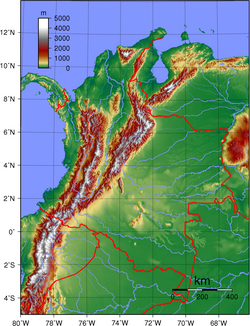
Key Facts
- Total Area: 1,141,748 km²
- Highest Points: Pico Cristóbal Colón and Pico Simón Bolívar, both reaching 5,700 m (18,701 ft).
- Coastlines: Access to both the Caribbean Sea (1,760 km) and the North Pacific Ocean (1,448 km).
- Population: 44,603,000 (as of October 13, 2008), ranking it as the 29th most populous country.
- Capital: Bogotá.
Territorial Boundaries and Coastlines
Colombia shares extensive land boundaries totaling 6,309 km. It is bordered by five different nations, creating a complex network of geopolitical and environmental intersections.
- Venezuela: 2,050 km
- Peru: 1,800 km
- Brazil: 1,644 km
- Ecuador: 590 km
- Panama: 225 km
In addition to its land borders, Colombia is one of the few countries in South America with coastlines on two different oceans, providing a total coastline of 3,208 km.
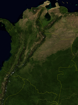
Natural Features and Environment
The environmental landscape of Colombia is characterized by extreme variations in elevation, ranging from 0 m at sea level to the towering peaks of the Andes. This variation supports a wide array of ecoregions—large areas of land with similar climate, soil, and biological communities.
Geological and Physical Landmarks
The country's physical geography is defined by several key features:
- Mountains and Volcanoes: A rugged terrain featuring high peaks and active volcanic systems.
- Water Systems: An extensive network of rivers, valleys, and plateaus.
- Glaciers and Islands: High-altitude glaciers and various island territories.
Biodiversity and Conservation
Due to its status as a megadiverse nation, Colombia focuses heavily on the protection of its flora and fauna. This includes the management of national parks, biosphere reserves, and protected areas to safeguard its unique birds and mammals.
| Feature | Measurement/Detail |
|---|---|
| Total Land Area | 1,141,748 km² |
| Total Land Boundaries | 6,309 km |
| Total Coastline | 3,208 km |
| Maximum Elevation | 5,700 m |
| Minimum Elevation | 0 m |
Administrative and Demographic Structure
Administratively, Colombia is organized into various divisions, including districts and municipalities, with Bogotá serving as the central capital and primary urban hub.
The country's demography is distributed across several distinct regions, most notably the Caribbean Region, which influences the cultural and economic landscape of the northern territories.
Frequently Asked Questions
What are the highest points in Colombia?
The highest points are Pico Cristóbal Colón and Pico Simón Bolívar, both of which reach an elevation of 5,700 meters (18,701 ft).
Which countries share a border with Colombia?
Colombia shares land borders with Venezuela, Peru, Brazil, Ecuador, and Panama.
Does Colombia have access to more than one ocean?
Yes, Colombia has coastlines on both the Caribbean Sea to the north and the North Pacific Ocean to the west.
What is the total area of Colombia?
The total area of Colombia is 1,141,748 square kilometers.
What does it mean that Colombia is a megadiverse country?
Being megadiverse means that Colombia possesses an exceptionally high level of biological diversity, containing a significant percentage of the world's total species of flora and fauna.