Channelization: Methods and Impacts of River Modification
Channelization is the process of modifying a river or stream to increase its discharging capacity. By altering the physical characteristics of a watercourse, engineers and land managers aim to move water more efficiently, primarily to reduce the risk of flooding in upstream areas. While these interventions can protect valuable assets, they often involve a complex trade-off between immediate local benefits and long-term environmental stability.
Methods of Increasing River Capacity
The most straightforward approach to improving a river's flow is the removal of obstructions. Natural impediments, such as fallen tree trunks, boulders, and gravel accumulations, as well as artificial barriers, can restrict the channel. Because every obstruction raises the river level to create the artificial fall necessary to push water through a restricted space, removing these obstacles lowers the flood height upstream and restores the total available fall.
Another method involves reducing the length of the channel by replacing winding, sinuous courses with straight cuts. This increases the effective fall of the river, allowing water to flow faster. However, this method faces significant challenges; the current naturally tends to erode banks to recreate a winding path. Even when banks are reinforced, straight cuts can cause shoals to form and may actually raise flood levels immediately downstream of the cut's termination.
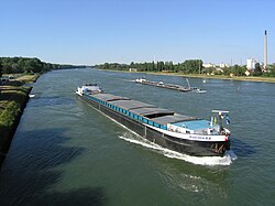
Specialized Applications: The English Fenlands
In regions where the natural fall is exceptionally low, such as the English Fenlands—land reclaimed from the sea—straight channels are essential. In these areas, drainage is largely artificial. To protect fertile, low-lying lands from inundation, engineers have constructed both straight river channels and additional channels specifically for rainfall discharge, known as drains.
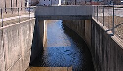
The Risks and Consequences of Modification
While channelization can protect specific assets like towns, it is not a universal solution. Extensive modifications often produce only limited reductions in overall flood damage. Furthermore, successful floodworks in one area may simply shift the problem downstream, increasing the threat to other communities.
Human activity often inadvertently hinders river flow through the introduction of mining refuse, solid weirs, fish-traps, and overly wide bridge piers. To combat this, river management regulations often mandate:
- The removal of fish traps that collect floating rubbish and leaves.
- The substitution of solid weirs with movable weirs.
- The enlargement of sluice-ways and the compulsory raising of gates during floods.
- The reduction of bridge pier width during reconstruction.
Due to these risks, recent trends in Europe have shifted toward the restoration of natural floodplains and winding courses, which allow floodwater to be held back and released more slowly.
Flood Prediction and Control Systems
Effective river management relies on data. By installing gauges in a main river and its tributaries, authorities can maintain continuous records of water heights. This data allows experts to determine the time it takes for floods to travel from tributaries to the main river.
With these records, the height and arrival time of a flood peak can be predicted with remarkable accuracy two or more days in advance. This early warning system allows weir-keepers to open movable weirs and provides riparian inhabitants—those living along the river banks—with critical time to prepare for inundation.
Protective Infrastructure: Embankments and Dams
When towns or valuable land are situated below the maximum flood level, water must be managed through diversion or confinement. This is typically achieved using flood-dams or continuous embankments on both sides of the river.
By placing embankments back from the river-bed margin, a wide flood-channel is created. This allows the river to overflow its banks into a controlled area while leaving the natural channel unaltered for ordinary flow. Depending on the need, embankments may be low (for seasonal meadow floods) or high. In some cases, embankments are designed with specific escape points to allow exceptionally high floods to exit in the least injurious areas, preventing catastrophic breaches of the banks.
Key Facts
- Primary Goal: Increasing discharging capacity to lower upstream flood levels.
- Straight Cuts: Increase effective fall but are prone to erosion and downstream shoaling.
- Environmental Shift: Modern European trends favor restoring natural floodplains over artificial channelization.
- Predictive Power: Gauge networks can predict flood peaks on main rivers two or more days in advance.
- Embankment Strategy: Setting embankments back from the riverbed preserves the natural channel for normal flow.
| Method | Primary Action | Main Advantage | Potential Drawback |
|---|---|---|---|
| Obstruction Removal | Clearing debris/boulders | Simple and efficient | Limited impact on large-scale floods |
| Straight Cuts | Replacing bends with straight lines | Increases effective fall | Bank erosion and downstream flooding |
| Embankments | Building side walls | Protects specific land/towns | May move flood risk downstream |
| Floodplain Restoration | Returning to winding courses | Slower water release | Requires significant land area |
Frequently Asked Questions
How do straight cuts affect a river's flow?
Straight cuts increase the effective fall of the river by reducing its total length, which allows water to move more quickly. However, they are often unstable as the current tends to erode the banks to return the river to a sinuous, winding state.
What are the risks of using embankments for flood control?
While embankments protect specific areas, they can move the flood problem further downstream, threatening other towns. Additionally, if an exceptionally high flood exceeds the embankment height, it can cause a disastrous breach.
How is flood arrival predicted?
By using gauges in tributaries and the main river, experts track the timing and height of water rises. This data allows them to calculate the travel time of a flood peak and predict its arrival at downstream stations up to two days in advance.
Why are some embankments designed to let water escape?
Designing specific escape points for rare, exceptionally high floods avoids the extreme cost of building walls for every possible scenario and prevents the catastrophic failure of the banks due to rapid flow and high pressure.
What is the difference between a drain and a river channel in the Fens?
In the English Fenlands, river channels are the primary modified watercourses, while drains are additional straight channels specifically constructed to discharge rainfall and protect low-lying fertile land from inundation.