British Antarctic Territory
The British Antarctic Territory (BAT) is a wedge-shaped sector of Antarctica claimed by the United Kingdom. As one of the 14 British Overseas Territories, it is the largest by land area, extending from 60°S latitude south to the South Pole, and spanning between 20°W and 80°W longitude. This remote region is a hub for international scientific cooperation, though its territorial status remains a subject of complex international diplomacy.
Unlike traditional territories, the BAT has no native inhabitants. Its population consists entirely of rotating staff from research and support stations, primarily those operated by the British Antarctic Survey (BAS), as well as facilities maintained by Argentina, Chile, and other nations.
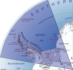
Key Facts
- Total Area: 1,709,400 km² (660,000 sq mi).
- Highest Point: Mount Hope, reaching 3,239 m (10,627 ft).
- Governance: A dependency under a constitutional monarchy, administered by the Foreign and Commonwealth Office.
- Primary Purpose: Peaceful scientific research and discovery.
- Population: Approximately 250 people during the summer season.
- Official Language: English.
History and Territorial Claims
The United Kingdom's claim to this region dates back to letters patent issued in 1908 and 1917. Originally, the area was administered as separate dependencies of the Falkland Islands—specifically Graham Land, the South Orkney Islands, and the South Shetland Islands—before the British Antarctic Territory was formally established on March 3, 1962.
During World War II, the UK launched Operation Tabarin in 1943, a secret military project to provide reconnaissance and meteorological data. This operation eventually transitioned into a civilian effort, becoming the Falkland Islands Dependencies Survey and later the British Antarctic Survey (BAS), which remains the primary body for UK scientific research in the region.
The Antarctic Treaty
In 1959, the Antarctic Treaty was signed to demilitarize the region and ensure Antarctica remained a zone for peaceful research. Coming into effect in 1961, the treaty suspended all territorial claims. Article 4 specifically prohibits the assertion of new claims or the enlargement of existing ones while the treaty is in force.
While the UK, Australia, France, New Zealand, and Norway mutually recognize each other's claims, most other countries do not. Notably, Argentina and Chile maintain their own claims that overlap with the British Antarctic Territory.
Geography and Environment
The territory's topography is dominated by the Antarctic Peninsula, the South Shetland Islands, the South Orkney Islands, and the Ronne Ice Shelf. In 2012, the southern third of the territory—a triangular area of 437,000 square kilometers—was named Queen Elizabeth Land in honor of Queen Elizabeth II's Diamond Jubilee.
The landscape is extreme, with over 99% of the surface covered by a permanent ice sheet that can reach thicknesses of 5,000 meters. Vegetation is sparse, consisting mostly of mosses and lichens, though two flowering plants exist: the Antarctic hairgrass and Antarctic pearlwort.
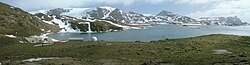
Wildlife is concentrated along the coasts. The region is home to six species of seals and seven species of penguins, along with visiting birds such as albatrosses and petrels.
Natural Resources and Controversy
While the Antarctic Treaty prohibits mineral and oil development, reports in May 2024 suggested that Russia had discovered extensive oil and gas reserves (estimated at 511 billion barrels) within areas claimed by the UK. This has led to international debate over whether such activities are genuine scientific research or prospecting for resources.
Administration and Law
The BAT is administered by the Foreign and Commonwealth Office through an appointed Commissioner. Despite the lack of a permanent population, the territory maintains a full legal and postal administration. It is self-financing, generating revenue through income tax and the sale of postage stamps to global collectors.
The Royal Navy supports the region via the ice patrol ship HMS Protector, while the RRS Sir David Attenborough provides critical scientific support during the Antarctic summer.
Nationality and Citizenship
The territory is part of the British Overseas Territories for nationality purposes. While naturalization is not permitted, individuals born in the territory before 1983 could hold British Overseas Territories citizenship (BOTC) and British citizenship. Laws changed on January 1, 1983, to require that at least one parent be a BOTC or ordinarily resident to grant citizenship to children born in the territory.
Research and Tourism
The British Antarctic Survey operates two permanently staffed facilities: Halley Research Station and Rothera Research Station. Other sites, such as Signy, Fossil Bluff, and Sky Blu, are staffed only during the summer.
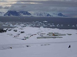
Tourism is centered around historic sites like Port Lockroy on Goudier Island. Managed by the UK Antarctic Heritage Trust, Port Lockroy attracts roughly 10,000 visitors annually who visit its museum, post office, and nearby gentoo penguin colony.
| Category | Details |
|---|---|
| Capital/Largest City | Rothera |
| Sovereign Claimant | United Kingdom |
| Currency | Pound sterling (£) |
| Time Zone | UTC-03:00 |
| Internet TLDs | .aq, .uk |
| Highest Peak | Mount Hope (3,239 m) |
Frequently Asked Questions
Who lives in the British Antarctic Territory?
There are no native inhabitants. The population consists of scientists and support staff from the British Antarctic Survey and other international organizations, totaling approximately 250 people during the summer.
Is the UK's claim to the territory recognized?
The claim is recognized by other claimant nations like Australia, France, New Zealand, and Norway. However, it is disputed by Argentina and Chile, and most other countries do not recognize any national claims in Antarctica due to the Antarctic Treaty.
What is the purpose of the Antarctic Treaty?
The treaty, signed in 1959, ensures that Antarctica is used exclusively for peaceful purposes, prohibits military activity, and freezes all territorial claims to encourage international scientific cooperation.
Can you get British citizenship by being born in the BAT?
Only those born in the territory before January 1, 1983, could automatically acquire British Overseas Territories citizenship. After that date, citizenship is only granted if at least one parent is a BOTC or ordinarily resident in the territory.
What is Queen Elizabeth Land?
Named in 2012 for the Diamond Jubilee of Queen Elizabeth II, it is a triangular region in the southern third of the BAT, covering approximately 437,000 square kilometers and extending to the South Pole.