Audubon Park: A Historic Urban Oasis in New Orleans
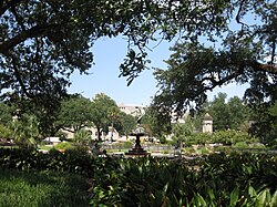
Nestled in the Uptown neighborhood of New Orleans, Louisiana, Audubon Park serves as a sprawling 350-acre sanctuary for residents and visitors alike. Bordered by the Mississippi River and St. Charles Avenue, the park is strategically located across from Tulane University and Loyola University. Named in honor of the renowned naturalist and artist John James Audubon, who settled in New Orleans in 1821, the park blends natural beauty with a rich historical legacy.
Today, the park is owned by the City of New Orleans and operated by the Audubon Nature Institute, remaining open to the public year-round.
Key Facts
- Total Area: Approximately 350 acres.
- Established: 1871.
- Location: Uptown New Orleans, six miles west of the city center.
- Key Landmarks: The Tree of Life, Ochsner Island, and the Golf Club at Audubon Park.
- Recreation: A 1.7-mile paved ring road and a 2.2-mile dirt perimeter path.
A Journey Through History
From Plantations to Public Space
Before it became a municipal treasure, the land was divided between two plantations: the Étienne de Boré Plantation (downstream) and the Pierre Foucher Plantation (upstream). By 1825, the Foucher family owned the entire tract. Following a period of abandonment by Louis Frederic Foucher, the land saw significant military use during the American Civil War by both Union and Confederate armies, as well as serving as a staging area for the Buffalo Soldiers (African American cavalry regiments).
In 1871, the land was sold by Foucher's widow to developers Bloomer and Southworth, who subsequently sold the riverside portion to the city to establish the park.
Development and Evolution
Originally considered as "Upper City Park," the area saw little development until it hosted the World Cotton Centennial of 1884. While most fair buildings were later demolished, a large iron ore rock from the Alabama State exhibit remains today. The park's current layout is largely based on a design by John Charles Olmsted of the prestigious Olmsted Brothers landscape architecture firm.
Throughout the 20th century, the park evolved. The Audubon Zoo was established here, receiving upgrades via the Works Progress Administration. While several mid-century attractions—such as swan boats and a miniature railway—were removed in the 1970s, the park continues to adapt. Notably, during Hurricane Katrina in 2005, the park's location on the Mississippi River's natural levee kept it above flood levels, allowing it to serve as a critical helicopter port and encampment for relief workers.
Park Features and Attractions
Recreation and Sports
The riverside area, known as Riverview Park, is colloquially called "The Fly." This nickname stems from a modernist, butterfly-shaped shelter built in the 1960s and removed in the 1980s. The area now provides sports fields and picnic facilities.
The Golf Club at Audubon Park, which opened in 1898, was renovated in 2002 into a Par 3 executive course. Additionally, the park features the David Berger - Avenger Field, renamed in 2002 to honor a Tulane University graduate killed during the 1972 Olympic Games hostage crisis.
Wildlife and Nature
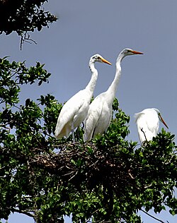
For nature enthusiasts, Ochsner Island is a premier birding destination. The island's rookery (a colony of breeding birds) attracts hundreds of wading birds, including great egrets, snowy egrets, ibis, and various herons. Visitors can also spot anhingas, double-crested cormorants, and migratory black-bellied whistling ducks in the lagoons.
Park Summary Table
| Feature | Detail |
|---|---|
| Size | 350 acres (1.4 km) |
| Coordinates | 29°56′03″N 90°07′25″W |
| Primary Operator | Audubon Nature Institute |
| Key Trails | 1.7-mile ring road; 2.2-mile dirt path |
| Notable Flora | Live oak trees, Tree of Life |
Frequently Asked Questions
Why is the riverside area called "The Fly"?
The name is a reference to a butterfly-shaped river viewing shelter constructed in the 1960s. Although the structure was demolished in the 1980s, the nickname persisted.
What is the significance of the iron ore rock in the park?
The rock was part of the Alabama State exhibit during the World Cotton Centennial of 1884. While local lore sometimes identifies it as a meteorite, it is actually iron ore.
Is Audubon Park accessible for runners and cyclists?
Yes. The park offers a 1.7-mile paved ring road closed to automobile traffic, as well as a 2.2-mile dirt perimeter path for those seeking a less congested route.
Which birds can be seen at Ochsner Island?
The rookery attracts a wide variety of wading birds, including great, cattle, and snowy egrets, as well as ibis, little blue herons, green herons, and night herons.
How did the park fare during Hurricane Katrina?
Because the park is situated on the Mississippi River's natural levee (high ground), it avoided the flooding that affected much of New Orleans, though some old live oak trees were blown down.