1947 Fort Lauderdale Hurricane: A Devastating Category 4 Storm
In September 1947, a powerful and long-lived tropical cyclone, designated as George by the Air Weather Service, tore through the Bahamas and the southern United States. Known as the Fort Lauderdale hurricane, this storm was a rare "Great Hurricane"—a term used to describe storms with winds exceeding 125 mph that spread hurricane-force winds over 100 miles or more. Its path of destruction spanned from the eastern Atlantic to the Gulf Coast, leaving a trail of significant casualties and economic loss.
The storm's intensity and scale made it the only "Great Hurricane" of the late 1940s, characterized by extreme barometric pressure and devastating wind speeds that challenged the infrastructure of the era.
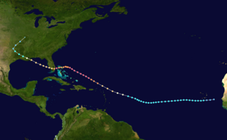
Key Facts
- Peak Intensity: Category 4 major hurricane with maximum sustained winds of 145 mph (230 km/h).
- Lowest Pressure: 938 mbar (27.70 inHg).
- Human Toll: 51 direct fatalities and 935 injuries.
- Financial Impact: $84.2 million in 1947 USD (approximately $1.21 billion in 2025 USD).
- Regions Affected: The Bahamas, Florida, Louisiana, and Mississippi.
Meteorological History
The cyclone first formed in the eastern Atlantic Ocean on September 4, 1947. It transitioned into a hurricane less than a day later, marking it as the third hurricane of the 1947 Atlantic season. For the first four days of its existence, the storm moved in a south-by-west direction before turning northwest on September 9, where it began to intensify rapidly.
By September 15, the storm reached its peak intensity of 145 mph as it approached the Bahamas. While contemporaneous forecasts suggested the hurricane would strike further north, the storm unexpectedly turned west, setting a direct course for South Florida.
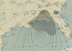
Regional Impacts
The Bahamas
The hurricane crossed the northern Bahamas at its peak intensity. The region experienced a massive storm surge—an abnormal rise of water generated by a storm, over and above the predicted astronomical tides—and heavy structural damage. Despite the severity of the wind and water, no fatalities were reported in the Bahamas.
Florida
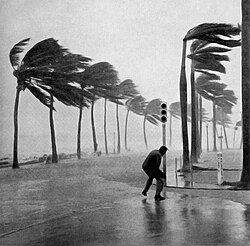
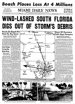
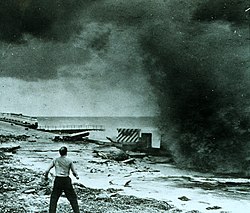
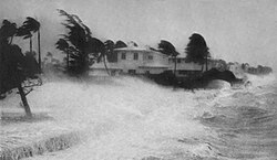
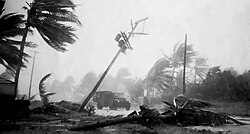
Upon striking South Florida, the hurricane brought violent winds and heavy surf. In West Palm Beach and Miami, residents battled extreme conditions that downed utility poles and palm trees. The storm's impact was felt heavily in coastal areas, where seawalls were battered by the surge and urban centers faced significant flooding.
The Gulf Coast
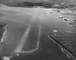
After crossing Florida, the storm entered the Gulf of Mexico and eventually impacted Louisiana and Mississippi. The storm caused widespread devastation, leveling buildings and flooding critical infrastructure, including the Moisant Airport. The Gulf Coast regions suffered the highest number of fatalities, particularly in Mississippi.
The hurricane finally became extratropical and dissipated on September 21, 1947.
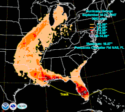
Summary of Damages and Casualties
The following table provides a detailed breakdown of the human and financial costs associated with the 1947 Fort Lauderdale hurricane.
| Region | Deaths | Injuries | Damages (1947 USD) |
|---|---|---|---|
| Caribbean and Bahamas | 0 | N/A | N/A |
| Florida | 17 | 186 | $31,800,000 |
| Louisiana | 12 | 95 | $24,000,000 |
| Mississippi | 22 | 654 | $28,438,000 |
| Total | 51 | 935 | $84,238,000 |
Frequently Asked Questions
What was the peak intensity of the 1947 Fort Lauderdale hurricane?
The hurricane reached a peak intensity of 145 mph (230 km/h), classifying it as a Category 4 major hurricane on the Saffir-Simpson scale.
How many people died as a direct result of the storm?
There were 51 direct fatalities resulting from the hurricane, with the highest death toll occurring in Mississippi.
What was the total economic damage caused by the hurricane?
The total damage was estimated at $84.2 million in 1947 USD, which adjusts to approximately $1.21 billion in 2025 USD.
Which areas were most affected by the storm?
The storm affected the Bahamas, Florida, Louisiana, and Mississippi.
What is a "Great Hurricane" in the context of this storm?
A "Great Hurricane" is defined as a storm with winds over 125 mph that spreads hurricane-force winds over 100 miles or more, while generating high tides, low pressures, and extensive casualties.