Yemen Geography and Administrative Structure
Located in the Northern and Eastern Hemispheres, Yemen is a strategically positioned country in Southwest Asia. Situated within the Middle East on the southern tip of the Arabian Peninsula, it serves as a critical link between the Eurasian landmass and the surrounding maritime routes. The country operates within the UTC+03 time zone.
Yemen's physical landscape is defined by a diverse range of terrains, from rugged highlands to extensive coastlines. The nation spans a total area of 527,968 km², making it a significant geographic entity in the region.
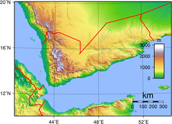
Key Facts
- Highest Point: Jabal An-Nabi Shu'ayb at 3,666 meters (12,028 ft).
- Lowest Point: The Arabian Sea at 0 meters.
- Coastline: 1,906 km of coastal territory.
- Land Borders: 1,746 km total, bordering Saudi Arabia (1,458 km) and Oman (288 km).
- Population: Approximately 22,389,000, ranking as the 50th most populous country globally.
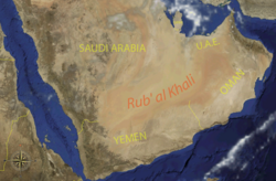
Natural Geographic Features
The environment of Yemen is characterized by a variety of ecoregions and geological formations. While the country possesses no glaciers, its landscape is marked by significant mountains, volcanoes, and valleys. The hydrology of the region includes various rivers, lakes, and waterfalls that support the local ecosystem.
Yemen's biodiversity is preserved through various protected areas, including national parks and biosphere reserves. These regions are home to a diverse array of fauna, specifically various species of mammals and birds.
Beyond the mainland, Yemen includes several islands, adding to its maritime complexity and ecological diversity. The country also hosts several World Heritage Sites, recognizing its cultural and natural significance.
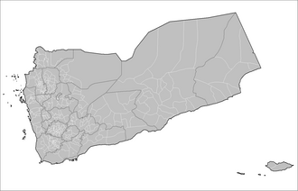
Administrative Divisions
Yemen is organized into a hierarchical administrative structure to manage its diverse regions. The primary division consists of governorates, which are further subdivided into districts (known as muderiah) and sub-districts.
Currently, the country is divided into 21 governorates. These are further broken down into 333 districts and 2,210 sub-districts. As of 2001, these sub-districts were further divided into 38,284 villages. The national capital is Sana'a.
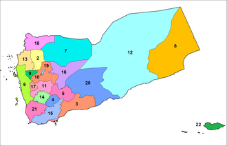
Governorate Overview
The governorates vary significantly in size and population. For instance, Hadramaut is the largest by area, while Ta'izz and Al Hudaydah are among the most populous regions.
| Governorate | Capital City | Area (km²) | Population (2004) |
|---|---|---|---|
| Hadramaut | Mukalla | 195,626 | 1,028,556 |
| Al Mahrah | Al Ghaydah | 78,073 | 88,594 |
| Al Jawf | Al Jawf | 46,170 | 443,797 |
| Ta'izz | Ta'izz | 11,573 | 2,393,425 |
| Amanat Al Asimah | San'a' | 126 | 1,747,834 |
| Socotra | Hadibou | 3,796 | 175,020 |
Frequently Asked Questions
What is the highest point in Yemen?
The highest point in Yemen is Jabal An-Nabi Shu'ayb, which reaches an elevation of 3,666 meters (12,028 ft).
Which countries share a land border with Yemen?
Yemen shares land boundaries with Saudi Arabia to the north (1,458 km) and Oman to the northeast (288 km).
How is Yemen administratively divided?
Yemen is divided into 21 governorates, which are further subdivided into 333 districts (muderiah) and 2,210 sub-districts.
What is the total area and population of Yemen?
Yemen covers an area of 527,968 km² and has a population of approximately 22,389,000 people.
Does Yemen have any glaciers?
No, there are no glaciers present in Yemen.