Whitireia Park: A History of Land, Legacy, and Restoration
Whitireia Park is more than just a scenic coastal reserve; it is a landscape woven with centuries of cultural significance, legal struggle, and environmental resilience. From the early voyages of Polynesian explorers to the modern reclamation of ancestral lands by the Ngāti Toa Rangatira iwi (tribe), the park serves as a living record of New Zealand's complex history.
Pre-European History and Māori Heritage
The history of the area begins with the legendary Polynesian explorer Kupe, who is believed to have landed at Komangarautawhiri, just south of Tītahi Bay. Oral traditions recount that Kupe's canoe drifted away on an outgoing tide before returning on the incoming tide. For centuries, the anchor stone of this canoe remained in Onehunga Bay as a respected site. Local lore notes that in the 1840s, British troops who broke pieces off the stone subsequently drowned, an event viewed by some Māori as punishment for sacrilege. While the stone is now housed at the Museum of New Zealand Te Papa Tongarewa, a monument marks its original location at the Onehunga Bay carpark.
Before European arrival, Māori utilized the coastal waters for harvesting kina (sea urchin), pāua (abalone), and kuku (mussels). By the mid-1820s, Ngāti Toa conquered the region under the leadership of Te Rauparaha, drawn by the area's strategic proximity to early European trading ports. Evidence of this early occupation remains today in the form of kumara-growing terraces visible above the headland cliffs. Archaeological surveys by the Department of Conservation indicate that Māori occupation continued into the 1840s.
The Gift of Land and Legal Conflict
Between 1847 and 1848, Ngāti Toa arranged a gift of approximately 200 hectares (500 acres) at Whitireia to George Selwyn, the Bishop of New Zealand, via Octavius Hadfield. This gift was intended to facilitate the establishment of a school for Māori children. Because Māori land could only be acquired by the Crown at the time, the land was first gifted to the Governor, who then placed it under the Porirua Trust for the Bishop.
The trust remained unexecuted for thirty years, and the promised college was never built. When Ngāti Toa sought the return of the land, the matter reached the Supreme Court in 1877 in the case of Wi Parata v Bishop of Wellington. Chief Wiremu Parata claimed a breach of contract and a violation of the Treaty of Waitangi (the founding document between the British Crown and Māori). On October 17, 1877, Chief Justice James Prendergast dismissed the claim, infamously declaring the treaty a "simple nullity" and "worthless." This ruling heavily influenced Treaty-related legal decisions for several decades. Eventually, the land was vested in the Porirua College Trust Board in the early 1900s, allowing it to be sold.
The Era of Radio Transmission
In 1935, the New Zealand Broadcasting Service purchased 40 hectares (99 acres) of the land to establish an AM radio transmitting station. This move allowed the 2YA station to relocate from Mount Victoria and serve as the national emergency radio station. Prime Minister Michael Joseph Savage officially opened the Tītahi Bay Transmitter station on January 25, 1937.
The site continued to evolve technologically, with a replacement antenna constructed in 1979. Standing at 212 meters (696 feet), it was the tallest man-made structure in New Zealand at the time of its completion.
Establishing the Trust Reserve
Whitireia Park was formally established in 1976 through a partnership between a local trust board and the Broadcasting Corporation of New Zealand, with support from local businesses and Ngāti Toa. A management plan finalized in 1978 brought the Department of Conservation into the fold.
Over the following decades, the park underwent several improvements, including the construction of a perimeter track and the removal of abandoned vehicle bodies by the New Zealand Defence Force. While Radio New Zealand (RNZ) maintained control of 53 hectares for its transmission site, much of the remaining land was leased for grazing to mitigate fire risks.
Environmental efforts began in 2006 with the replanting of the wetland behind the Onehunga Bay carpark. However, the park faced a major setback in February 2010 when a wildfire destroyed much of the headland's vegetation.
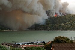
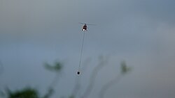
In the aftermath of the fire, community working bees were organized to replant the devastated areas and restore the natural landscape.
Modern Governance and the Return of Ownership
The Wellington Regional Council took control of the park in March 2011, maintaining a collaborative management relationship with Ngāti Toa. A significant shift occurred with the Ngāti Toa Rangatira Claims Settlement Act 2014, which settled historical Treaty of Waitangi grievances. This act vested several key sites back to Ngāti Toa Rangatira, including Te Onepoto Bay, Onehunga Bay, and the Whitireia Urupā (burial ground).
The settlement also created a joint board to govern the Whitireia Park recreation reserve, the Onehunga Bay historic reserve, and the Te Onepoto Bay recreation reserve. This board consists of members appointed by the Greater Wellington Regional Council and the Ngāti Toa Rangatira Trust, with the council managing daily operations.
The final piece of the land puzzle was resolved in October 2025. After RNZ proposed rezoning some of its greenfield land for residential development, Ngāti Toa exercised its first right of refusal under the Public Works Act and the 2014 Settlement Act. Ngāti Toa purchased the remaining 53 hectares (130 acres) from RNZ, reclaiming full ownership of the sacred maunga (mountain) after 177 years. RNZ continues to operate its AM transmission service via a 12-hectare (30-acre) lease from Ngāti Toa.
Key Facts
- Kupe's Legacy: The park is linked to the explorer Kupe, whose anchor stone is now in the Te Papa museum.
- Legal Precedent: The 1877 Wi Parata case famously dismissed the Treaty of Waitangi as a "nullity."
- Infrastructure: The 1979 antenna was once New Zealand's tallest man-made structure at 212 meters.
- Land Reclamation: In 2025, Ngāti Toa regained ownership of the entire sacred maunga after 177 years.
- Environmental Recovery: The park is recovering from a devastating wildfire that occurred in February 2010.
| Period/Year | Event/Status | Key Entity Involved |
|---|---|---|
| Pre-1840s | Traditional occupation and kumara cultivation | Ngāti Toa |
| 1847–1848 | Gift of 200 ha for a school (later disputed) | Bishop George Selwyn / Porirua Trust |
| 1935 | Purchase of 40 ha for AM radio transmitter | NZ Broadcasting Service |
| 1976 | Establishment of the park reserve | Broadcasting Corp of NZ / Local Trust |
| 2011 | Management transition | Wellington Regional Council |
| 2014 | Vesting of key sites via Settlement Act | Ngāti Toa Rangatira |
| 2025 | Purchase of final 53 ha from RNZ | Ngāti Toa Rangatira |
Frequently Asked Questions
Who is the current owner of the land at Whitireia Park?
As of October 2025, Ngāti Toa Rangatira has reclaimed ownership of the sacred maunga, including the 53 hectares previously owned by Radio New Zealand (RNZ).
What was the significance of the Wi Parata v Bishop of Wellington case?
This 1877 case was pivotal because the Chief Justice declared the Treaty of Waitangi a "simple nullity," a decision that negatively impacted Māori land claims for many decades.
What happened to the vegetation on the headland in 2010?
A wildfire in February 2010 destroyed much of the vegetation on the headland, leading to subsequent community replanting efforts.
Does Radio New Zealand still have a presence in the park?
Yes, RNZ continues to operate its AM transmission service on a 12-hectare (30-acre) lease from Ngāti Toa.
What are some of the historical Māori features still visible in the park?
Visitors can still see the kumara-growing terraces located above the headland cliffs, which date back to the period of Ngāti Toa occupation.