Uruguay River: The Vital Waterway of South America
The Uruguay River (known as Río Uruguay in Spanish and Rio Uruguai in Portuguese) is one of South America's most significant fluvial systems. Flowing from north to south, it serves as a critical natural boundary between Brazil, Argentina, and Uruguay. Beyond its political importance, the river is a powerhouse of biodiversity and energy, carving through diverse landscapes before joining the Paraná River to form the massive Río de la Plata estuary.
Key Facts
- Total Length: Approximately 1,838 km (1,142 mi).
- Basin Size: 365,000 km² (141,000 mi²).
- Countries: Brazil, Argentina, and Uruguay.
- Primary Use: Hydroelectric power generation via dams like Salto Grande and Itá.
- Unique Feature: Home to a submerged canyon and the parallel-flowing Moconá Falls.
Geography and Course
The river originates in the Serra Geral of Brazil, where the Pelotas and Canoas rivers converge at an elevation of approximately 1,800 meters (5,900 ft). In its upper reaches, the river traverses broken, uneven terrain, creating a series of rapids and falls that render this section non-navigable.
As it flows south, the river defines the eastern borders of Argentina's Misiones, Corrientes, and Entre Ríos provinces, as well as the western borders of several Uruguayan departments, including Artigas, Salto, and Colonia.
The Submerged Canyon and Moconá Falls
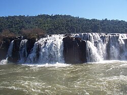
One of the most scientifically intriguing aspects of the Uruguay River is its submerged canyon. Formed during the Ice Age when the climate was drier and the river narrower, this canyon reaches depths of up to 100 meters below the current riverbed. This geological feature is visible in only two locations, most notably at the Moconá Falls (also known as the Yucumã Falls).
Unlike traditional waterfalls that drop perpendicularly, the Moconá Falls run parallel to the river's flow. They range from 10 to 12 meters in height and can stretch up to 3 km in width. Due to seasonal water levels, these falls are only visible for about 215 days of the year, transforming into rapids during the remaining 150 days.
The Río de la Plata Basin
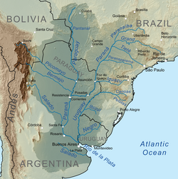
The Uruguay River eventually merges with the Paraná River to create the Río de la Plata, a vast estuary that empties into the Atlantic Ocean. The river is navigable from Salto Chico onwards, with the Río Negro serving as its most significant tributary, flowing for 500 km through Uruguay before joining the main stem.
Hydrology and Infrastructure
The river's discharge varies significantly by location and season. For instance, the multiannual average discharge at Nueva Palmira is 7,058 m³/s, while at El Soberbio, it is 2,384 m³/s. This consistent flow makes the river an ideal source for hydroelectricity, utilized by the Itá Dam in Brazil and the Salto Grande Dam on the border of Argentina and Uruguay.
To facilitate international trade and travel, five major international bridges span the river, including the Integration Bridge and the Paso de los Libres-Uruguaiana International Bridge between Brazil and Argentina, and the Salto Grande, General Artigas, and Libertador General San Martín bridges between Argentina and Uruguay.
| Feature | Detail |
|---|---|
| Length | 1,838 km |
| Basin Area | 365,000 km² |
| Source Rivers | Pelotas and Canoas (Brazil) |
| Mouth | Río de la Plata |
| Average Discharge (Nueva Palmira) | 7,058 m³/s |
Environmental and Diplomatic History
The river has been the center of diplomatic tension, most notably the cellulose plant conflict. In 2005, Argentina and Uruguay clashed over the construction of pulp mills by companies ENCE and Botnia at Fray Bentos. Argentina alleged that Uruguay violated a 1975 treaty and that the plants would pollute the river.
The dispute led to blockades of international bridges and was eventually taken to the International Court of Justice (ICJ). In 2010, the ICJ ruled that while Uruguay had failed to properly inform Argentina of the construction, the mills did not pollute the river. This led to the creation of a joint commission to coordinate future river activities.
Frequently Asked Questions
What does the name "Uruguay" mean?
The name is derived from the Guaraní language. Interpretations include "the river of the uru" (an indigenous bird) or "the river of the uruguá" (an indigenous gastropod known as Pomella megastoma).
What makes the Moconá Falls unique?
Unlike most waterfalls that flow across a river, the Moconá Falls flow parallel to the river's current. They are also seasonal, becoming rapids for about 150 days of the year.
Which countries share the Uruguay River?
The river forms the borders between Brazil, Argentina, and Uruguay.
How is the river used economically?
The primary economic use of the Uruguay River is the generation of hydroelectric power through major dams such as the Salto Grande and Itá dams.
Where does the Uruguay River end?
The river ends where it joins the Paraná River to form the Río de la Plata estuary, which eventually flows into the Atlantic Ocean.