UK Postcodes: History, Structure, and Function
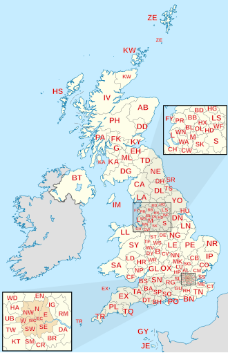
In the United Kingdom, the alphanumeric strings used to route mail are known as postcodes. While many countries use purely numeric systems, the UK is one of only 11 countries or territories globally to employ an alphanumeric format. Far more than just a mailing aid, these codes serve as precise routing instructions that divide the land into specific geographic areas.
A full postcode typically identifies a small group of addresses—usually around 15, though some contain only a single household—or a major delivery point. This system allows the Royal Mail to automate sorting and ensure efficient delivery across the British Isles.
Key Facts
- Alphanumeric System: The UK uses a combination of letters and numbers for routing.
- Hierarchical Structure: Postcodes are divided into areas, districts, sectors, and units.
- Scale: As of June 2016, there are 124 postcode areas and approximately 29.9 million addresses.
- Evolution: The modern national system was adopted in stages between 1959 and 1974.
- Versatility: Beyond mail, postcodes are used for satellite navigation, insurance pricing, and determining school catchment areas.
The Evolution of the Postal System
The current system did not appear overnight; it evolved from named postal districts first introduced in London in 1857. By the 1860s, other large cities began adopting similar models. In 1917, London's districts were further subdivided and assigned distinct numbers, a practice that spread to other cities by 1934.
The General Post Office (now Royal Mail) devised the modern alphanumeric system to build upon these earlier districts, rolling it out nationally between 1959 and 1974. This transition allowed for the integration of automated sorting technology, significantly increasing the speed of mail processing.
Understanding Postcode Structure
A UK postcode is split into two primary parts: the outward code and the inward code.
The Outward Code
The outward code is the first part of the postcode and is used to route mail to the correct local sorting office. It consists of:
- Postcode Area: Usually one or two letters (e.g., "TR" for Truro) representing a major post town or regional area. There are 121 geographic postcode areas.
- Postcode District: A number (or letter and number) that further narrows the location. While most districts are numbered consecutively from 1, some start from 0 (such as BS or CM) or 10 (such as AB or SO).
The Inward Code
The inward code is the second part of the postcode, used for final sorting by the local delivery office. It consists of:
- Postcode Sector: A single digit that identifies a specific neighborhood or group of streets.
- Postcode Unit: Two letters that pinpoint a small group of addresses or a single large-scale delivery point.
| Component | Part of Code | Example (YO31 1EB) | Function |
|---|---|---|---|
| Area | Outward | YO | Major post town/region |
| District | Outward | YO31 | Local sorting office |
| Sector | Inward | 1 | Neighborhood group |
| Unit | Inward | EB | Specific address group |
Specialized and Non-Geographic Postcodes
Not all postcodes represent a physical street location. Non-geographic postcodes are allocated for specific purposes, such as PO Boxes or high-volume mail recipients. For example, in the Brighton (BN) area, districts BN50-BN52 are dedicated exclusively to PO Boxes.
Some organizations are granted customized postcodes for branding or operational efficiency. Notable examples include:
- SW1A 0AA: House of Commons
- SW1A 1AA: Buckingham Palace
- W1A 1AA: BBC Broadcasting House
- BX Postcode Area: A non-geographic area used by several major banks, including Barclays and Lloyds.
International Variations: Territories and Dependencies
British Overseas Territories (BOTs) and Crown dependencies often use their own independent systems. While some follow the UK format, others use unique identifiers. For instance, Gibraltar uses GX11 1AA, while others like Ascension Island (ASCN 1ZZ) and the Pitcairn Islands (PCRN 1ZZ) use four-letter outward codes.
Frequently Asked Questions
How many addresses does a single postcode cover?
Most postcodes are shared by several neighboring properties, typically covering about 15 addresses. However, some postcodes in England and Wales contain only one household, while "large user" postcodes are assigned to single addresses that receive massive volumes of mail.
What is the Postcode Address File (PAF)?
The Postcode Address File (PAF) is the comprehensive database maintained by Royal Mail that contains every delivery point in the UK, linking addresses to their respective postcodes.
Why do some postcode districts not follow consecutive numbering?
Numbering can vary based on geographic reality or operational transfers. In the NE area, for example, a gap exists between NE49 and NE61 to reflect the substantial physical distance between Haltwhistle and Morpeth.
Are the letters Q, V, and X used in postcodes?
The letters Q, V, and X are generally not used in the first position of the outward code, with the exception of special codes like XX and XM.