Tignes: Geography, History, and Climate of a High-Altitude Resort
Tignes is a renowned high-altitude destination defined by its dramatic landscapes and a complex history of engineering and transformation. Nestled within a deep valley, the area is characterized by a unique geological layout that creates a sense of enclosure and grandeur, making it a premier location for winter sports and alpine exploration.
The Natural Stadium
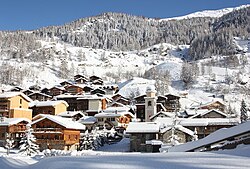
The main villages of Tignes are situated at the base of a high-altitude valley. This valley is anchored by the Grande Motte at its furthest point, with several other peaks encircling the area. The opposite end of the valley opens up and drops away toward the Lac du Chevril. Because of this specific geography, the area feels like a massive open-air arena. Local residents, known as Tignards, refer to this phenomenon as the Stade Naturel, or "Natural Stadium."
The Five Villages of Tignes
The Tignes ski resort is comprised of five distinct villages, each offering a different perspective of the valley:
- Tignes Val Claret, Tignes le Lac, and Le Lavachet: These three are clustered closely together at an altitude of 2100 m.
- Tignes Les Boisses: Located further down the valley, situated above the dam.
- Tignes-les-Brévières: Located below the dam.
Connectivity between these hubs is streamlined for visitors. All villages located above the dam are linked by a free, continuous shuttle bus service. Tignes Les Brévières, the only village below the dam, is accessible via a free gondola service that operates late into the evening. Notably, Tignes Les Brévières is the only remaining part of the original town; the other villages were developed as part of the ski resort or as a result of the dam's construction.
The Barrage de Tignes and the Lost Village
The history of Tignes is inextricably linked to the Barrage de Tignes (Tignes Dam). The original village of Tignes sat at 1700 m in the Isère valley, below Val d'Isère. Following World War II, France's urgent need for electricity led to the decision to construct a massive hydro-electric dam in the valley.
While a milestone for French engineering, the project resulted in the original village being submerged. The dam was completed and the village drowned in 1952. To preserve the memory of the town, a replica of the original church was built in Tignes les Boisses. Every ten years, the Lac du Chevril (the lake created by the dam) is drained for maintenance, briefly revealing the ruins of the old village.
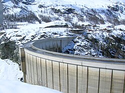
In 1989, the dam became a canvas for art when Jean-Marie Pierret, assisted by eight mountain climbers, painted a fresco of Hercules on its surface. This project was funded by private corporations to enhance the Olympic appeal of the region during the 1992 Winter Games held in nearby Albertville.
Climate and Weather Patterns
Tignes experiences a subarctic climate, categorized under the Köppen climate classification as Dfc. This is characterized by cold winters and short, cool summers. The average annual temperature is 2.8 °C (37.0 °F), with an average annual rainfall of 1,036.6 mm (40.81 in), peaking in August.
Temperature extremes are significant. The highest temperature ever recorded was 29.9 °C (85.8 °F) on July 23, 2019, while the coldest was −27.8 °C (−18.0 °F) on February 27, 2018.
| Metric | Coldest Month (Jan) | Warmest Month (Jul) | Annual Average |
|---|---|---|---|
| Daily Mean Temp | −5.3 °C (22.5 °F) | 11.5 °C (52.7 °F) | 2.8 °C (37.0 °F) |
| Mean Daily Max | −1.2 °C (29.8 °F) | 16.4 °C (61.5 °F) | 7.3 °C (45.1 °F) |
| Mean Daily Min | −9.3 °C (15.3 °F) | 6.6 °C (43.9 °F) | −1.6 °C (29.1 °F) |
| Avg Precipitation | 92.0 mm (3.62 in) | 100.3 mm (3.95 in) | 1,036.6 mm (40.81 in) |
Key Facts
- Stade Naturel: The local name for the valley's stadium-like geography.
- Village Layout: Five villages in total; Tignes Les Brévières is the only original settlement remaining.
- The Dam: Completed in 1952, it submerged the original village of Tignes.
- Artistic Landmark: The dam features a fresco of Hercules painted in 1989.
- Climate: Subarctic (Dfc) with an average annual temperature of 2.8 °C.
- Transport: Free shuttle buses link upper villages, while a gondola connects Tignes Les Brévières.
Frequently Asked Questions
What happened to the original village of Tignes?
The original village, located at 1700 m, was submerged in 1952 to make way for the construction of the hydro-electric Tignes Dam. Its remains become visible only once every ten years when the Lac du Chevril is drained for maintenance.
How do I travel between the different villages in Tignes?
Villages above the dam are connected by a free continuous shuttle bus. Tignes Les Brévières, located below the dam, is accessible via a free gondola service that runs late into the evening.
What is the "Stade Naturel"?
The "Stade Naturel" (Natural Stadium) is a term used by locals to describe the geography of the Tignes valley, which is surrounded by peaks and the Grande Motte, creating the feeling of being inside a large open stadium.
What is the weather like in Tignes?
Tignes has a subarctic climate. It is generally cold, with an annual average temperature of 2.8 °C. July is typically the warmest month, while January is the coldest.
Is there any remnant of the old town's architecture?
Yes, a replica of the original church from the submerged village was created and is located in Tignes les Boisses.