The Green Line of Beirut: A History of Division and Renewal
During the Lebanese Civil War, which spanned from 1975 to 1990, the city of Beirut was physically and socially fractured by a boundary known as the Green Line (Arabic: الخط الأخضر). Also referred to as the "Demarcation Line," this boundary served as a volatile frontier that split the capital into two distinct sectors, reflecting the deep sectarian and political divides of the era.
The name "Green Line" was derived from the lush foliage and vegetation that grew wild in the uninhabited "no man's land" between the opposing forces. This strip of greenery became a haunting symbol of a city divided against itself.
The Geography of Division
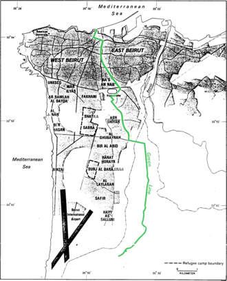
The Green Line generally stretched from the north to the south of Beirut, with Damascus Street serving as the primary thoroughfare following the line. It separated West Beirut, which was primarily controlled by Muslim factions, from East Beirut, which was predominantly Christian and controlled by the Lebanese Front.
While the division began as a split between Muslim and Christian populations, the complexities of the war eventually led the line to separate Sunni and Shia factions as well. Initially, the boundary was not absolute; some Christians lived in the west and some Muslims in the east. However, as the conflict persisted, these minorities often left their respective sectors, making each side more religiously and politically homogeneous.
Life Along the Demarcation Line
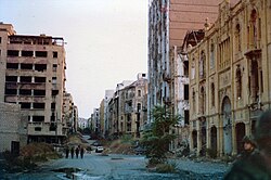
The Green Line was not a formal, walled border with continuous security. Instead, it was a dangerous zone characterized by militia checkpoints and the constant threat of snipers stationed atop buildings. The architecture of the area suffered immensely, with many buildings along the line being severely damaged or completely destroyed during the years of fighting.
The Siege of West Beirut
Because of its position, the Green Line was a strategic vulnerability for both sides. During the Israeli siege of West Beirut, Israeli armed forces surrounded the western sector and positioned tanks directly along the Green Line to maintain control and pressure.
The Syrian Withdrawal and PLA Presence
In August 1982, following the withdrawal of the Syrian military from East Beirut, the Palestine Liberation Army (PLA) was deployed to the Green Line under Syrian command. This deployment was met with disapproval from residents on both the eastern and western sides of the line.
Post-War Recovery and Urban Renewal
Following the end of hostilities in 1990, Beirut began the arduous process of healing its physical scars. Much of the devastation along the former Green Line was addressed through a massive urban renewal project led by Solidere in the Centre Ville (Downtown) district. Many of the destroyed buildings have since been rebuilt, transforming the former site of conflict into a modern city center.
Key Facts
- Duration: The line existed during the Lebanese Civil War from 1975 to 1990.
- Primary Divide: Separated predominantly Muslim West Beirut from predominantly Christian East Beirut.
- Naming: Called the "Green Line" due to the wild vegetation that grew in the uninhabited zone.
- Main Axis: Damascus Street was the primary road following the demarcation.
- Modern Status: Much of the area has been rebuilt via the Solidere urban renewal project.
| Feature | Details |
|---|---|
| Time Period | 1975–1990 |
| West Beirut | Mainly Muslim factions |
| East Beirut | Mainly Christian (Lebanese Front) |
| Key Landmark | Damascus Street |
| Post-War Developer | Solidere |
Frequently Asked Questions
Why was it called the Green Line?
It was called the Green Line because the area between the warring factions became a no-man's land. Since no one lived there, wild plants and foliage grew unchecked, creating a visible green strip across the city.
Was the Green Line a formal border?
No, there was no formal border or continuous security wall. Instead, the line was marked by militia checkpoints and the presence of snipers on rooftops.
Who controlled the two sides of the line?
West Beirut was primarily controlled by Muslim factions, while East Beirut was predominantly controlled by the Lebanese Front, a predominantly Christian coalition.
What happened to the area after the war?
The area underwent significant urban renewal, particularly in the Downtown (Centre Ville) district, through a project managed by the company Solidere, which rebuilt many of the destroyed structures.
Did people of different faiths live on both sides?
At the start of the war, the division was not absolute, and minorities lived on both sides. However, as the conflict continued, people tended to migrate to the sector that matched their religious affiliation, making the areas more homogeneous.