Semi-arid Pampas: The Dry Grasslands of Argentina
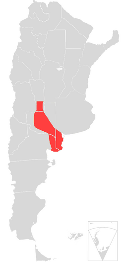
The Semi-arid Pampas, frequently referred to as the Dry Pampas, is a vast temperate grassland ecoregion located in south central Argentina. Spanning approximately 327,000 square kilometers, this region serves as a critical ecological transition zone, bridging the gap between the lush Humid Pampas to the east and the thornier Argentine Espinál to the west.
Geographically, the region encompasses most of La Pampa Province, as well as southern Cordoba, San Luis, and western Buenos Aires Provinces. Despite its size, the area is sparsely populated, with fewer than one million residents who benefit from some of the lowest poverty rates in the country.
Key Facts
- Total Area: 327,000 square kilometers.
- Average Rainfall: Approximately 700 mm (27 in), which is about one-third less than the Humid Pampas.
- Primary Land Use: Cattle and sheep ranching, alongside intensive crop cultivation.
- Iconic Species: The ñandú (Darwin's rhea) and the pampas deer.
- Major Protected Areas: Luro Park Natural Preserve and Lihué Calel National Park.
Environmental Characteristics
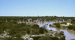
The landscape of the Semi-arid Pampas is defined by its minimal incline and the presence of frequent finger lakes. The soil here is generally sandier than in the eastern regions. The primary distinction between this biome and its humid neighbor lies in the lower rainfall quantities, soil quality, and resulting land use.
Flora and Vegetation
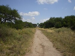
While extensive grasslands dominate the region, the groundcover consists of long-grass varieties similar to those found in global steppes. The natural landscape is punctuated by intermittent shrublands, featuring species such as carquejilla and caldén, both of which are valued for their medicinal properties, as well as the shade-providing algarrobo.
Many of the larger trees seen today are not native; ombúes, alders, and Italian cypresses were imported and planted primarily as landscaping or windbreaks.
Fauna and Wildlife
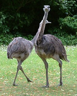
Due to unreliable rainfall and a sparse landscape, the wildlife of the Semi-arid Pampas shares similarities with that of Patagonia. The most prominent inhabitant is the ñandú, also known as Darwin's rhea. Historically, these birds were a primary protein source for indigenous peoples like the Puelches.
Between 1830 and 1880, ñandú populations were decimated during military campaigns intended to starve indigenous tribes into surrender. By the 1920s, the species neared extinction, but through legal protection, ñandú herds and pampas deer have since recovered substantially.
Other notable wildlife includes:
- Birds: Gray hawks, partridges, martins, coots, and storks.
- Mammals: Pumas, pampas foxes, cavias, and maras.
- Shared Species: Skunks and opossums, which are also common in North America.
Human Impact and Land Use
The demographic shift of the region began in the 1880s with the arrival of British-financed railways. This era brought white settlers, including former soldiers from the Conquest of the Desert, who were granted large estates. This led to the proliferation of fenced cattle and sheep ranches, which remain the dominant land use today. The region produces roughly four million cattle, accounting for one-tenth of Argentina's total production.
Since the 1940s, agricultural advancements have enabled the intensive cultivation of alfalfa, oats, sunflowers, and wheat.
Conservation and Ecological Threats
The region's ecological balance has faced challenges from economic growth and infrastructure. Hydroelectric projects have fostered urban centers like Santa Rosa, but dams along the Atuel River have caused disruptions to nearby wetlands, particularly around rural Algarrobo del Aguila, by releasing excess rainy-season water indiscriminately.
Conservation efforts gained momentum in 1971 when the descendants of Pedro Luro and Arminda Roca donated 7,600 hectares to the government, creating the Luro Park Natural Preserve. This was followed in 1977 by the establishment of the 9,900-hectare Lihué Calel National Park.
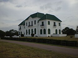
Despite these preserves, the ecosystem remains under pressure from irrigation activities and intensive grazing.
| Feature | Details |
|---|---|
| Location | South central Argentina (La Pampa, San Luis, Cordoba, Buenos Aires) |
| Climate | Temperate, semi-arid (approx. 700 mm annual rainfall) |
| Key Flora | Long-grass steppes, Caldén, Algarrobo |
| Key Fauna | Ñandú, Pampas deer, Puma, Pampas fox |
| Economic Drivers | Livestock (Cattle/Sheep), Wheat, Sunflowers |
Frequently Asked Questions
How does the Semi-arid Pampas differ from the Humid Pampas?
The Semi-arid Pampas receive about one-third less rainfall (approximately 700 mm) than the Humid Pampas and feature sandier soil and vegetation more similar to global steppes.
What is a ñandú?
The ñandú, also known as Darwin's rhea, is a large flightless bird native to the region. Once nearly extinct due to hunting and military campaigns, it is now protected by law.
Which protected areas are found in this ecoregion?
The two most significant protected areas are the Luro Park Natural Preserve and the Lihué Calel National Park, both located in La Pampa Province.
What are the primary agricultural products of the region?
The region is a major producer of cattle and sheep, and it also cultivates wheat, sunflowers, oats, and alfalfa.
What environmental threats does the region face?
The ecosystem is currently pressured by intensive grazing, irrigation activities, and the mismanagement of water release from hydroelectric dams along the Atuel River.