Poland Geography and Environmental Overview
Poland is a sovereign state located in Central Europe, situated within both the Northern and Eastern Hemispheres of Eurasia. As a prominent member of the European Union and NATO, Poland serves as a geographical bridge within the continent, operating under Central European Time (UTC+01) and Central European Summer Time (UTC+02).
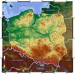
The country encompasses a total area of 312,679 km², characterized by a diverse landscape that ranges from the coastal plains of the north to the rugged peaks of the south.
Key Facts
- Capital: Warsaw
- Highest Point: Rysy (2,499 m / 8,199 ft)
- Lowest Point: Żuławy Wiślane (−1.8 m / −6 ft)
- Coastline: 440 km along the Baltic Sea
- Total Land Boundaries: 3,071 km
- Population: 38,115,967 (as of June 30, 2007)
Land Boundaries and Maritime Access
Poland shares extensive land borders with seven different nations, totaling 3,071 km. Its territorial limits are defined by the following boundaries:
- Czech Republic: 796 km
- Slovakia: 541 km
- Ukraine: 535 km
- Germany: 467 km
- Belarus: 418 km
- Russia: 210 km
- Lithuania: 104 km
To the north, Poland maintains a 440 km coastline along the Baltic Sea, providing critical maritime access to the rest of the world.
Natural Features and Environment
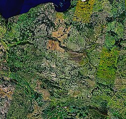
The environmental landscape of Poland is multifaceted, comprising various ecoregions, geological formations, and protected areas. The country's natural geography includes a variety of features such as glaciers, islands, lakes, and valleys. While the south is defined by mountains, the country also contains waterfalls and a complex network of rivers.
Poland is committed to environmental preservation through the establishment of National Parks and biosphere reserves. Its biodiversity is rich, with diverse populations of mammals, birds, and amphibians. Additionally, the nation is integrating renewable energy into its infrastructure to support its ecological goals.
The country is also home to several World Heritage Sites, recognizing its unique cultural and natural significance on a global scale.
Administrative Divisions
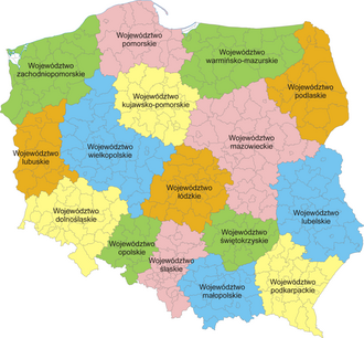
Poland is organized into a hierarchical administrative structure to manage its provinces and municipalities efficiently. The primary division is the voivodeship (the highest-level administrative province), which is further subdivided into powiats (districts) and gminas (municipalities).
| Category | Detail |
|---|---|
| Total Area | 312,679 km² |
| Population (2007) | 38,115,967 |
| Global Population Rank | 37th |
| Highest Elevation | Rysy (2,499 m) |
| Lowest Elevation | Żuławy Wiślane (−1.8 m) |
| Coastline Length | 440 km |
Frequently Asked Questions
What is the highest point in Poland?
The highest point in Poland is Rysy, which reaches an elevation of 2,499 meters (8,199 feet).
Which countries share a land border with Poland?
Poland shares land boundaries with the Czech Republic, Slovakia, Ukraine, Germany, Belarus, Russia, and Lithuania.
How is Poland administratively divided?
Poland is divided into voivodeships (provinces), which are further split into powiats (districts) and gminas (municipalities).
What is the lowest point of the Polish landscape?
The lowest point is found in Żuławy Wiślane, dipping to −1.8 meters (−6 feet) below sea level.
Which sea borders Poland to the north?
Poland is bordered to the north by the Baltic Sea, with a coastline extending 440 km.