NWS Norman: History and Evolution of Oklahoma's Weather Forecasting
The National Weather Service (NWS) office in Norman, Oklahoma, serves as a critical hub for meteorological surveillance and public safety in one of the most storm-prone regions of the United States. From its humble beginnings in a downtown opera house to its current state-of-the-art facility, the office has evolved alongside advancements in radar technology and atmospheric science to protect millions of lives.
The Evolution of the Central Oklahoma Forecast Office
The journey of weather forecasting in central Oklahoma began on November 1, 1890, when the U.S. Weather Bureau established its first local office at the Overholser Opera House in downtown Oklahoma City. As the city grew, so did the need for better facilities. By July 1, 1902, operations moved to the Culbertson Building, and by January 16, 1906, the bureau transitioned to a dedicated weather observatory at 1923 Classen Boulevard.
In 1932, the office began a gradual migration to Will Rogers Airport, eventually moving into a proprietary building on October 22, 1965. It was shortly after this move that the U.S. Weather Bureau was renamed the National Weather Service. The office remained at the airport until January 27, 1987, when it relocated to a purpose-built facility at Max Westheimer Airport in Norman, Cleveland County.
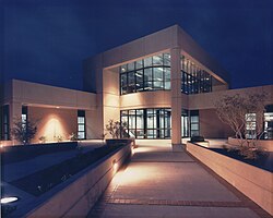
The Norman campus grew into a center of excellence for severe weather research. In 1990, the National Severe Storms Laboratory (NSSL) joined the site, followed in October 1995 by the National Severe Storms Forecast Center—now known as the Storm Prediction Center (SPC). This consolidation of expertise culminated on August 7, 2006, when the NWS office, the SPC, and the NSSL moved into the newly constructed National Weather Center on the University of Oklahoma's Research Campus.
Weather Forecasting and Operational Responsibilities
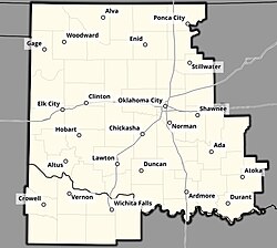
The Norman Weather Forecast Office (WFO) is responsible for general forecasting and the issuance of hazardous weather watches, warnings, and advisories across a vast region. This County Warning Area (CWA)—the specific geographic region for which an NWS office is responsible—encompasses 48 counties in Oklahoma and eight counties in western north Texas, serving major cities such as Oklahoma City, Lawton, Enid, and Wichita Falls.
While the Norman WFO handles local warnings, the Storm Prediction Center (SPC) manages the issuance of severe thunderstorm and tornado watches. The Norman office provides the necessary outlines and status updates for these SPC-issued watches within its CWA.
Emergency Continuity and Backup Protocols
To ensure uninterrupted public safety, NOAA operational guidelines allow for the transfer of forecasting and alert responsibilities to the NWS office in Tulsa during emergencies. Such transfers occur during system outages, power disruptions, or evacuations caused by imminent threats, such as a tornado on the ground.
A historic example of this necessity occurred on June 8, 1974. An F3 tornado caused a gas line rupture near the Will Rogers Airport office, forcing an evacuation. During this crisis, NWS officials requested that Jim Williams, the chief meteorologist at NBC affiliate WKY-TV (now KFOR-TV), temporarily assume warning responsibilities until the office could resume operations.
Impact on Major Weather Events
The Norman office has played a pivotal role in disseminating warnings for some of the most violent weather events in U.S. history. One of the most significant was the tornado outbreak of May 3, 1999. A massive supercell—a highly organized thunderstorm with a rotating updraft—produced a violent tornado that tracked through Bridge Creek and Moore.
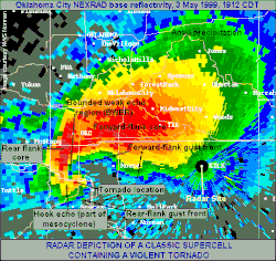
This specific tornado was the first in history to cause damage exceeding US$1 billion. Using a mobile Doppler on Wheels radar, scientists recorded maximum wind speeds at upper elevations of 301 ± 20 mph (484 ± 32 km/h), among the highest ever observed on Earth. In response to this catastrophe, staff meteorologist David Andra (who became Meteorologist in Charge in 2012) drafted the first-ever tornado emergency at 6:57 p.m. Central Time for Moore and southern Oklahoma City. This enhanced warning was designed to communicate the extreme danger to densely populated areas.
Key Facts
- Established: November 1, 1890, in Oklahoma City.
- Current Location: National Weather Center, University of Oklahoma Research Campus.
- Coverage Area: 48 Oklahoma counties and 8 western north Texas counties.
- Historic Event: Issued the first NWS tornado emergency during the May 3, 1999, outbreak.
- Wind Record: 301 ± 20 mph recorded during the May 3, 1999, tornado.
- Collaborative Campus: Houses the NWS, Storm Prediction Center (SPC), and National Severe Storms Laboratory (NSSL).
| Period | Location | Key Detail |
|---|---|---|
| 1890–1902 | Overholser Opera House | Original Oklahoma City base |
| 1902–1906 | Culbertson Building | Second downtown location |
| 1906–1932 | 1923 Classen Boulevard | Dedicated weather observatory |
| 1932–1987 | Will Rogers Airport | Transitioned to NWS branding |
| 1987–2006 | Max Westheimer Airport | Relocated to Norman, OK |
| 2006–Present | National Weather Center | OU Research Campus facility |
Frequently Asked Questions
What is the difference between the Norman WFO and the Storm Prediction Center?
The Storm Prediction Center (SPC) is responsible for issuing broad severe thunderstorm and tornado watches, while the Norman Weather Forecast Office (WFO) handles the specific local warnings, advisories, and general forecasting for its designated County Warning Area.
What is a "tornado emergency"?
A tornado emergency is an enhanced warning statement used to denote a particularly damaging tornado affecting densely populated areas, intended to convey a higher level of imminent danger to the public and media.
Which cities are served by the Norman NWS office?
The office serves major cities including Oklahoma City, Lawton, Enid, and Wichita Falls, covering 48 counties in Oklahoma and 8 in western north Texas.
What happens if the Norman office has a power failure during a storm?
Under NOAA guidelines, responsibility for forecasts and weather alerts can be transferred to the National Weather Service office in Tulsa to ensure continuous coverage.
What was significant about the May 3, 1999, tornado?
It was the first tornado to cause over US$1 billion in damage and featured some of the highest wind speeds ever recorded on Earth, reaching 301 ± 20 mph.