National Centers for Environmental Information: Managing the World's Environmental Data Archives
The National Centers for Environmental Information (NCEI) serves as one of the world's most significant repositories for atmospheric, coastal, geophysical, and oceanic data. As a specialized agency within the United States government, NCEI is responsible for the stewardship, preservation, and distribution of environmental information that spans from the depths of the ocean to the surface of the Sun.
Operated by the National Environmental Satellite, Data, and Information Service (NESDIS)—an office of the National Oceanic and Atmospheric Administration (NOAA)—NCEI provides critical data products to a diverse global audience. This includes scientists, government officials, academic institutions, the business community, and the general public.
Key Facts
- Established: 2015 through the merger of three NOAA data centers.
- Data Volume: Over 60 petabytes of data as of mid-2023.
- Headquarters: Asheville, North Carolina.
- Parent Agency: National Oceanic and Atmospheric Administration (NOAA).
- Core Mission: Streamlining the collection and preservation of environmental data for global use.
History and Formation
NCEI was established by the Consolidated and Further Continuing Appropriations Act, 2015 (Public Law 113-235). The agency was created to meet the rising demand for accessible environmental information by consolidating three existing NOAA entities into a single, streamlined organization:
- National Climatic Data Center (NCDC)
- National Geophysical Data Center (NGDC)
- National Oceanographic Data Center (NODC), which included the National Coastal Data Development Center (NCDDC)
By merging these centers, NOAA aimed to implement consistent data stewardship—the management and protection of data assets—across all scientific disciplines. Today, NCEI works with the ISC World Data System to ensure that this vital information remains free and accessible to all.
Massive Data Archives and Services
The scale of NCEI's archive is immense. As of mid-2023, the agency manages more than 60 petabytes of data. To put this in perspective, that is equivalent to more than 700 million filing cabinets filled with documents. While much of this is digital, NCEI also maintains a physical archive in a climate-controlled facility containing thousands of boxes of paper records, microfilm, and microfiche.
Data is gathered from a vast array of sophisticated sources, including:
- Satellites and weather balloons
- Land-based stations and radar
- Ocean buoys and ships
- Remotely operated underwater vehicles
- Forecasting and climate models
- Paleoclimatological research (the study of past climates)
Scientific Contributions and Expertise
NCEI is not merely a storage facility; it is a hub of active scientific research. The agency's Subject Matter Experts (SMEs) are highly sought-after collaborators in international research. In 2022 alone, NCEI SMEs authored more than 90 papers in peer-reviewed journals, averaging eight papers per month. Their research covers diverse topics such as hurricanes, ocean warming, fire science, solar flares, and marine microplastics, appearing in prestigious publications like Nature Climate Change and The Astrophysical Journal.
Real-World Applications of Environmental Data
The data preserved by NCEI has profound implications for various economic sectors and public safety. By understanding past environmental patterns, industries can make more informed decisions for the future.
Industry Use Cases
- Agriculture: Corn farmers use data to optimize fertilizer application, while cattle ranchers utilize the U.S. Drought Monitor to manage herd sizes and feed purchases.
- Transportation: Freight railways use NCEI products like the Global Historical Climatology Network to predict landslides and avoid severe storms.
- Finance and Insurance: The reinsurance industry uses environmental data to assess risks associated with natural disasters.
- Commerce: Retail and manufacturing businesses analyze climate data to understand how weather patterns influence consumer sales.
- Maritime: Fishing vessels rely on ocean and coastal data to identify promising fishing conditions.
Organizational Structure and Locations
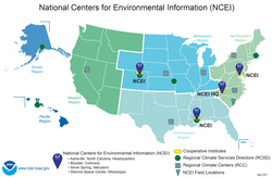
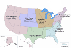
While headquartered in Asheville, North Carolina, NCEI maintains a significant presence in Boulder, Colorado; Silver Spring, Maryland; and the Stennis Space Center in Mississippi. The agency also manages the Regional Climate Center Program, which provides localized information through six specialized offices:
- High Plains Regional Climate Center (Lincoln, Nebraska)
- Midwestern Regional Climate Center (West Lafayette, Indiana)
- Northeast Regional Climate Center (Ithaca, New York)
- Southeast Regional Climate Center (Chapel Hill, North Carolina)
- Southern Regional Climate Center (College Station, TX)
- Western Regional Climate Center (Reno, Nevada)
Furthermore, NCEI collaborates with cooperative institutes—academic and nonprofit partners—to support its mission. These include the Cooperative Institute for Satellite Earth System Studies (CISESS), the Cooperative Institute for Research in Environmental Sciences (CIRES), and the Northern Gulf Institute (NGI).
Summary of NCEI Agency Profile
| Category | Details |
|---|---|
| Parent Agency | National Environmental Satellite, Data, and Information Service (NESDIS) |
| Headquarters | Asheville, North Carolina |
| Director | Deke Arndt |
| Annual Budget (2023) | $71.4 million |
| Staff Size | Approximately 500 employees |
Frequently Asked Questions
What happened to NCEI during Hurricane Helene?
In September 2024, the NCEI headquarters in Asheville experienced flooding and storm damage from Hurricane Helene. This impacted infrastructure, limited website availability, and postponed certain monthly reports. However, NCEI confirmed on October 4th that all archived data products remained safe.
How is NCEI data collected?
Data is collected through a variety of methods, including satellite observations, land-based weather stations, ocean buoys, ships, weather balloons, radar, and climate models, as well as paleoclimatological research.
Who can access NCEI data?
NCEI data is made available to a wide range of users, including scientists, government agencies, the business community, academia, non-governmental organizations, and the general public.
What is the difference between NCEI and NOAA?
NOAA is the parent agency (National Oceanic and Atmospheric Administration) responsible for monitoring the entire ocean and atmosphere. NCEI is a specific agency within NOAA that focuses on the archiving and management of the data collected by NOAA and other global institutions.
How much data does NCEI manage?
As of mid-2023, NCEI manages over 60 petabytes of data, which is a massive digital archive supplemented by a physical archive of paper, microfilm, and microfiche.