Nam-gu: A Comprehensive Overview of Pohang's Southern District
Located within the city of Pohang in the North Gyeongsang Province of South Korea, Nam-gu (literally meaning "South District") serves as a vital administrative component of the region. As a non-autonomous district, it functions alongside its counterpart, Buk District, to manage the diverse landscape and population of the Pohang area.
Spanning a significant land area, Nam-gu is characterized by a mix of urban neighborhoods and rural townships, reflecting the varied geography of the Yeongnam region. Whether looking at its administrative structure or its demographic density, Nam-gu represents a key piece of the South Korean coastal landscape.
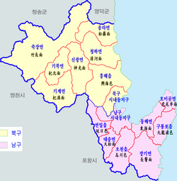
Key Facts
- Location: Pohang, North Gyeongsang Province, South Korea.
- Total Area: 393.02 km² (151.75 sq mi).
- Population: 253,670 (as of 2012).
- Population Density: 645/km² (1,670/sq mi).
- Administrative Divisions: 7 dong, 3 eup, and 4 myeon.
- Local Dialect: Gyeongsang.
Administrative Structure and Divisions
To manage its territory effectively, Nam-gu is organized into several distinct types of administrative divisions. These include dong (neighborhoods), eup (towns), and myeon (townships). Each of these larger divisions is further subdivided into numerous ri, which are small villages.
Towns (Eup)
The district contains three primary towns:
- Guryongpo-eup
- Yeonil-eup
- Ocheon-eup
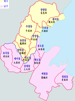
Townships (Myeon)
The rural townships within Nam-gu include:
- Daesong-myeon
- Donghae-myeon
- Janggi-myeon
- Homigot-myeon
Neighborhoods (Dong)
The urbanized neighborhoods consist of:
- Sangdae-dong
- Haedo-dong
- Songdo-dong
- Cheongnim-dong
- Jecheol-dong
- Hyogok-dong
- Daei-dong
Summary of Nam-gu Statistics
| Category | Details |
|---|---|
| Country | South Korea |
| Province | North Gyeongsang |
| City | Pohang |
| Total Area | 393.02 km² |
| 2012 Population | 253,670 |
| Dialect | Gyeongsang |
Frequently Asked Questions
What does the name "Nam-gu" mean?
The name Nam-gu translates literally to "South District" in English.
How is Nam-gu divided administratively?
Nam-gu is divided into 7 dong (neighborhoods), 3 eup (towns), and 4 myeon (townships).
Is Nam-gu an autonomous district?
No, Nam-gu is classified as a non-autonomous district within the city of Pohang.
What is the primary dialect spoken in Nam-gu?
The local dialect spoken in the area is Gyeongsang.
What are the major towns in the district?
The three major towns (eup) are Guryongpo-eup, Yeonil-eup, and Ocheon-eup.