Mungyeong: A Journey Through South Korea's Historic Mountainous Heartland
Nestled within the scenic landscapes of North Gyeongsang Province, Mungyeong is a city where history and nature converge. The name itself, which translates roughly to "hearing good news," reflects a sense of optimism that permeates this urban-rural complex. Once a vital hub for the coal industry, Mungyeong has successfully transitioned into a premier destination for tourism, leveraging its breathtaking mountain passes and deep historical roots to welcome visitors from around the world.
The modern city was formed in 1995 through the merger of Jeomchon City and Mungyeong County. Today, the administrative and economic heart of the region is centered in the principal town of Jeomchon, serving as a gateway to the rugged beauty of the Sobaek Mountains.
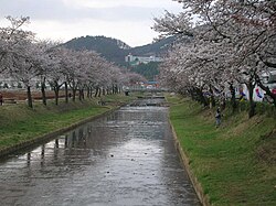
Key Facts
- Location: North Gyeongsang Province, South Korea.
- Population: Approximately 67,544 (as of September 2024).
- Primary Economy: Tourism, agriculture (notably apples), and light industry.
- Topography: Dominated by the Sobaek Mountains and deep valleys.
- Major Landmark: Mungyeong Saejae, a historic mountain pass.
A Rich Historical Legacy
Mungyeong's strategic importance dates back centuries. By 505 AD, the rising power of the Silla Kingdom controlled the area, establishing mountain fortresses to monitor movement into western Korea. During the Unified Silla period, the region was organized under the province of Sangju, and significant religious sites like the Gwaneumsa temple were constructed near the Haneuljae pass.
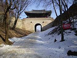
The city's significance grew during the Joseon period when the road from Seoul to Busan was established over the Mungyeong Saejae pass. To protect travelers from brigandage, gates were erected along this route—structures that remain preserved today as a testament to the area's historical role as a vital transit corridor.
Modern Transitions and Infrastructure
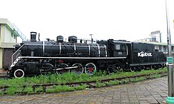
The 20th century brought significant changes, including the introduction of railroads during the Japanese occupation. Jeomchon Station opened in 1924, and later, the Gaeun Line was constructed in the 1950s to support the local coal mining industry. While the decline of coal in the 1980s shifted the economic focus, the completion of the Jungbu Naeryuk Expressway in 2004 has revitalized local transit and commerce.
Geography and Climate
The terrain of Mungyeong is defined by its dramatic topography. The city's shape roughly approximates a right triangle, with its hypotenuse formed by the peaks of the Sobaek Mountains. The highest point is the 1,161-meter Munsu peak of Worak Mountain. Millions of years of erosion have carved spectacular cliffs and escarpments throughout the region, creating a landscape that is as challenging as it is beautiful.
Due to its mountainous location, Mungyeong experiences a humid continental climate. The area sees significant temperature fluctuations, with annual averages around 11°C (52°F). Rainfall is most intense during the monsoonal season in July and August, with the city receiving approximately 1,300 mm of precipitation annually.
Economy and Local Life
While 75% of the land is mountainous and unsuitable for large-scale farming, agriculture remains a cornerstone of the local economy. Mungyeong is particularly well-known for its orchard farming, with apple cultivation playing a vital role. These products are exported widely to major urban centers across South Korea.
The tourism sector has seen steady growth since the 1990s. Visitors are drawn to the historic passes, the annual traditional tea bowl festival, and modern attractions like the Mungyeong Dansan Tourist Monorail, which offers a 35-minute round trip to the summit of Mount Dan.
Administrative Overview
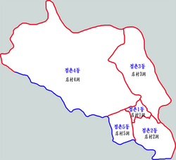
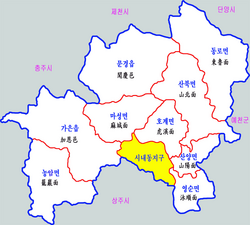
Mungyeong is organized into 2 eup (towns), 7 myeon (townships), and 5 dong (neighborhoods). The dong districts are primarily clustered around the central town of Jeomchon.
| Category | Details |
|---|---|
| Total Area | 911.73 km² |
| Administrative Divisions | 2 Eup, 7 Myeon, 5 Dong |
| Time Zone | UTC+9 (KST) |
| Major Transport | Gyeongbuk Line (Rail), National Highways |
| Primary Language/Dialect | Korean (Gyeongsang dialect) |
Frequently Asked Questions
What is the main tourist attraction in Mungyeong?
Mungyeong Saejae is the most prominent attraction, offering historic mountain passes and scenic views that were once part of the main road between Seoul and Busan.
How is the weather in Mungyeong?
Mungyeong has a humid continental climate. It features distinct seasons with significant rainfall during the summer monsoon and colder temperatures in the winter compared to coastal regions.
What is Mungyeong famous for producing?
The region is highly regarded for its agricultural products, particularly its apples grown in local orchards.
How can I travel to Mungyeong?
The city is accessible via the Gyeongbuk Line passenger rail, which stops at Jeomchon Station, and by automobile via national highways and the Jungbu Naeryuk Expressway.
Is Mungyeong a mountainous region?
Yes, the topography is dominated by the Sobaek Mountains, with much of the land consisting of valleys, cliffs, and high peaks like Worak Mountain.