Muirtown: A Historic Gateway to the Caledonian Canal
Located in the west end of Inverness within the Scottish Highlands, Muirtown (known in Gaelic as Baile an Fhraoich) is a district defined by its relationship with the water. From its educational hubs like Muirtown Primary School to its maritime infrastructure, the area serves as a quiet yet significant landmark on the edge of the city.
The Muirtown Basin and Maritime History
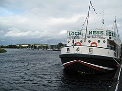
The centerpiece of the area is the Muirtown Basin, an expansion of the Caledonian Canal situated near its northeastern termination. Located approximately one mile (1.5 km) northwest of Inverness city centre, the basin sits between Clachnaharry and Muirtown.
The basin was planned in the early 19th century by the renowned engineer Thomas Telford (1757–1834). Telford envisioned the site as a second harbour for the city of Inverness. However, the facility struggled to keep pace with the rapid evolution of maritime technology; the ships of the era quickly grew too large for the basin to accommodate. Consequently, the harbour never reached its intended potential and has since transitioned into its current role as a marina.
Canal Infrastructure and Landmarks
Beyond the basin, Muirtown is home to critical engineering features of the Caledonian Canal. Immediately to the south of the basin lie the Muirtown Locks, a flight of four locks—chambered sections used to raise or lower boats between different water levels—located a mile (1.5 km) west northwest of the city centre.
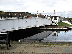
To the north of the basin, the landscape is marked by the Muirtown Swing Bridge, a specialized bridge designed to pivot horizontally to allow canal traffic to pass through.
Muirtown in Literature
The area's distinct atmosphere has also captured the imagination of authors. In the novel Mr Standfast by John Buchan, Muirtown serves as the setting for a tense episode. The protagonist, Richard Hannay, navigates the area while attempting to evade the Scottish police and hunt a spy.
Key Facts
- Gaelic Name: Baile an Fhraoich.
- Location: West end of Inverness, Scottish Highlands.
- Primary Engineer: Thomas Telford designed the basin in the early 19th century.
- Current Use: The former planned harbour now operates as a marina.
- Infrastructure: Features a flight of four locks and a swing bridge.
| Feature | Description | Location Relative to City Centre |
|---|---|---|
| Muirtown Basin | Former planned harbour, now a marina | 1 mile (1.5 km) Northwest |
| Muirtown Locks | Flight of four canal locks | 1 mile (1.5 km) West Northwest |
| Muirtown Swing Bridge | Canal crossing bridge | North of the basin |
Frequently Asked Questions
Who designed the Muirtown Basin?
The basin was planned in the early 19th century by the engineer Thomas Telford.
Why did the Muirtown Basin fail to meet its original purpose?
It was intended to be a second harbour for Inverness, but it could not accommodate the increasing size of ships that came into use shortly after its planning.
What is the current function of the Muirtown Basin?
The basin now serves as a marina.
What is the Gaelic name for Muirtown?
The Gaelic name for Muirtown is Baile an Fhraoich.
Which literary work features Muirtown?
Muirtown appears in the novel Mr Standfast by John Buchan, featuring the character Richard Hannay.