The Great Glen: Scotland's Strategic Geological Divide
The Great Glen (Scottish Gaelic: An Gleann Mòr), also known as Glen Albyn or Glen More, is a striking geological feature that carves a path through the heart of the Scottish Highlands. Stretching approximately 62 miles (100 km) in a nearly straight line, it connects the city of Inverness on the edge of the Moray Firth to Fort William at the head of Loch Linnhe.
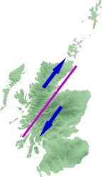
This dramatic landscape is not merely a valley but a manifestation of the Great Glen Fault, a major geological fracture that bisects the Highlands. This fault separates the Grampian Mountains to the southeast from the Northwest Highlands to the northwest.
Key Facts
- Length: 62 miles (100 km).
- Endpoints: Inverness (Northeast) and Fort William (Southwest).
- Geology: Formed by the Great Glen Fault.
- Major Waterways: Includes Loch Ness, Loch Oich, and Loch Lochy.
- Transport Links: Home to the A82 road and the Caledonian Canal.
Transport and Connectivity
Due to its natural linear path, the Great Glen serves as a vital transportation corridor across the Highlands. The Caledonian Canal and the A82 road both utilize this route to link the northeast coast at Inverness with the west coast at Fort William.
Historically, the region saw various attempts at rail connectivity. The Invergarry and Fort Augustus Railway was established in 1896, running from the southern end of the glen to the southern tip of Loch Ness. However, it was never extended to reach Inverness and eventually closed in 1947.
For modern travelers, the Great Glen Way opened in 2002. This long-distance route is designed for walkers, cyclists, and canoeists, utilizing a network of forestry tracks, canal paths, footpaths, and short sections of road.
Strategic and Military Importance
The glen's geography made it a critical site for controlling the Highland Scottish clans, particularly during the Jacobite risings of the 18th century. This strategic value is evidenced by the construction of three key fortifications: Fort William in the south, Fort Augustus in the center, and Fort George located just northeast of Inverness.
Hydrology and Water Features
The Great Glen is characterized by a series of lochs (Scottish lakes) connected by rivers. While the Caledonian Canal integrates these lochs into its route, the connecting rivers remain non-navigable. The watershed—the dividing line between drainage basins—is located between Loch Oich and Loch Lochy.
From northeast to southwest, the natural water features are arranged as follows:
- River Ness
- Loch Dochfour
- Loch Ness
- River Oich
- Loch Oich
- Loch Lochy
- River Lochy
- Loch Linnhe
At the southern terminus, the River Lochy and the Caledonian Canal empty into Loch Linnhe, a sea loch. At the northern end, the River Ness flows into the Beauly Firth, where it meets the Moray Firth.
Seismic Activity and Infrastructure
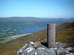
While earthquakes near the Great Glen Fault are typically minor, the potential for seismic activity is a critical factor in regional engineering. A primary example is the Kessock Bridge, which opened in 1982 to carry the A9(T) road north from Inverness. Because the bridge crosses the line of the Great Glen fault under the Moray/Beauly Firth, it was designed with specialized seismic buffers to ensure structural stability.
| Feature | Details |
|---|---|
| Total Distance | 62 miles (100 km) |
| Primary Geological Feature | Great Glen Fault |
| Major Cities/Towns | Inverness, Fort William, Fort Augustus |
| Key Transport Routes | A82 Road, Caledonian Canal, Great Glen Way |
| Primary Water Bodies | Loch Ness, Loch Oich, Loch Lochy, Loch Linnhe |
Frequently Asked Questions
What is the Great Glen Fault?
The Great Glen Fault is a major geological fracture that runs through the Scottish Highlands, creating the linear valley known as the Great Glen and dividing the region into the Grampian Mountains and the Northwest Highlands.
Which lochs are found in the Great Glen?
The primary lochs in the glen, moving from northeast to southwest, are Loch Dochfour, Loch Ness, Loch Oich, and Loch Lochy, eventually leading to the sea loch, Loch Linnhe.
How can travelers navigate the Great Glen today?
Travelers can use the A82 road for driving, the Caledonian Canal for boating, or the Great Glen Way for walking, cycling, and canoeing.
Is the Great Glen prone to earthquakes?
Seismic activity in the area tends to be minor, but it is significant enough that infrastructure, such as the Kessock Bridge, must be built with seismic buffers to mitigate risk.
Why were forts built along the Great Glen?
Forts like Fort William, Fort Augustus, and Fort George were established due to the glen's strategic importance in controlling the Highland clans, especially during the 18th-century Jacobite risings.