M10 Corridor: Syria's Strategic Highway Connecting Iraq to the Mediterranean
The M10 Corridor serves as a vital artery in northern Syria, functioning as a critical link within the Arab Mashreq International Road Network. This strategic highway facilitates the movement of overland travelers and goods from eastern nations, such as Iraq, directly to the Mediterranean Sea. While locally known as the M4 motorway, the Syrian Ministry of Transport designates it as the M10 to align with international agreements.
Spanning approximately 215 kilometers (134 mi) between Latakia and Saraqib, the route extends further east from Al-Bab toward the Iraqi border, ultimately reaching Mosul. By intersecting with the M5 motorway at Saraqib, the M10 integrates the industrial hubs of the east with the coastal ports of the west.
Key Facts
- International Role: Part of the Arab Mashreq International Road Network connecting Iraq to the Mediterranean.
- Total Length: 215 kilometers between Latakia and Saraqib, extending further east to the Iraqi border.
- Maximum Speed: Up to 130 km/h on high-standard sections.
- Key Terminals: Starts at the Al-Yaarubiyah border crossing and ends at the Al-Bassa interchange in Latakia.
- Major Cities Served: Mosul, Al-Yaarubiyah, Manbij, Al-Bab, Aleppo, Saraqib, Ariha, and Jisr al-Shughur.
Technical Specifications and Route Layout
The M10 varies in design based on its location and the era of its construction. Starting at the Al-Yaarubiyah border crossing, the road begins as a two-lane expressway. As it progresses through towns and villages, it often utilizes a median strip for separation. After crossing the Qara Qozak Bridge, it continues as a two-lane expressway through Manbij and Al-Bab.
Upon entering Al-Bab, the infrastructure upgrades to a four-lane expressway divided by a Jersey barrier (a modular concrete barrier used to separate lanes of traffic). This section continues until it meets the M15 (Aleppo-Raqqa Road). Travelers can then use the eastern Aleppo Bypass Motorway to access the M5. From this point to Saraqib, the road expands to three lanes in each direction, separated by a Jersey barrier.
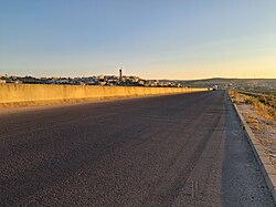
Between Saraqib and Ariha, the route operates as a dual carriageway divided by a median strip. Beyond the Ariha Bridge, the highway enters a high-specification zone constructed by the Kuwaiti Al-Kharafi company and opened in 2011. This section features three lanes in each direction and a tall, cast-in-place Jersey barrier, allowing for speeds of up to 130 km/h.
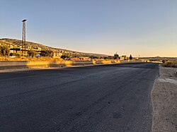
This high-standard segment concludes at the Al-Bassa interchange in Latakia, where it intersects with the M1 highway. Along this stretch, numerous bridges provide essential connectivity to villages and cities including Salanfah, Al-Haffah, and Jisr al-Shughur.
Operational Challenges and Maintenance
The M10 has faced significant disruptions due to regional conflict and subsequent infrastructure damage. In May 2020, parts of the highway in northeastern Syria were reopened following Russian mediation after being captured by opposition fighters in 2019.
More recently, the highway in the Latakia governorate faced closures in July 2025 for the maintenance of a 6-kilometer stretch. This was necessary to repair bridges, specifically Bridge B46, which was damaged by remnants of the former Ba'athist regime. The destruction of Bridge B46 rendered that section unusable, forcing traffic onto a detour via the old Aleppo-Latakia Road (Route 4).
In January 2026, Minister of Transport Engineer Yaarub Bader visited the repair sites managed by the General Authority for Road Transport and various contracting companies, aiming to restore the motorway before the tourist season. By March 2026, authorities reopened the road linking Aleppo with eastern areas previously held by the Kurdish-led Syrian Democratic Forces (SDF), following an integration agreement.
M10 Corridor Summary
| Feature | Details |
|---|---|
| Designation | M10 (International) / M4 (Local) |
| Primary Route | Al-Yaarubiyah (Iraq Border) to Latakia (Mediterranean) |
| Key Infrastructure | Jersey barriers, Qara Qozak Bridge, Al-Bassa interchange |
| Max Speed Limit | 130 km/h (Latakia section) |
| Construction Partner | Kuwaiti Al-Kharafi company (Western section) |
| Current Status | Partially operational (Bridges B46-B50 under maintenance) |
Frequently Asked Questions
What is the difference between the M4 and M10 designations?
The road is locally referred to as the M4 motorway, but it is designated as the M10 according to the Arab Mashreq International Road Network agreement to standardize international corridors.
Which company constructed the high-standard section near Latakia?
The section from Ariha to the Al-Bassa interchange in Latakia was constructed by the Kuwaiti Al-Kharafi construction company in cooperation with the Syrian Ministry of Transport.
Why was a detour required near Latakia in 2025?
A 6-kilometer stretch was closed to repair damage caused by remnants of the former regime, specifically the destruction of Bridge B46, forcing travelers to use the old Route 4.
How does the M10 connect to the Iraqi border?
The motorway begins at the Al-Yaarubiyah border crossing as a two-lane expressway, extending from Mosul in Iraq through northern Syrian cities like Al-Bab and Manbij.
What is the maximum speed allowed on the M10?
On the high-standard sections between Ariha and Latakia, the road specifications allow for speeds of up to 130 kilometers per hour.