M-46 Highway: A Trans-Peninsular Journey Across Michigan
M-46 stands as one of only three trans-peninsular highways in Michigan's Lower Peninsula. Stretching from the shores of Lake Michigan in Muskegon to the edge of Lake Huron in Port Sanilac, it provides a vital east-west artery across the state. It shares this rare trans-peninsular status with only two other routes: M-55, which connects Manistee to Tawas City, and M-72, which runs from Empire to Harrisville.
The highway is maintained by the Michigan Department of Transportation (MDOT). To manage maintenance and infrastructure, MDOT monitors traffic using Average Annual Daily Traffic (AADT)—a metric that calculates the average number of vehicles using a specific roadway segment on any given day of the year. Traffic density varies significantly along M-46; in 2009, MDOT recorded a peak of 30,505 AADT just east of the US 31 freeway near Muskegon, while the lowest volume was 1,855 vehicles daily near the eastern terminus.
Due to its importance to national mobility, defense, and the economy, portions of M-46 are designated as part of the National Highway System (NHS). These sections include the stretch from the western terminus to US 31, and the segment between Cedar Springs and the M-53 junction in Sanilac County.
Key Facts
- Route Scope: One of three highways crossing the entire Lower Peninsula.
- Termini: Starts in Muskegon (West) and ends in Port Sanilac (East).
- Peak Traffic: 30,505 AADT near the US 31 freeway.
- Lowest Traffic: 1,855 AADT near the eastern terminus.
- Maintenance: Managed by the Michigan Department of Transportation (MDOT).
From Muskegon to Saginaw
M-46 begins at the intersection of Muskegon and Apple avenues, near the downtown business district of Muskegon. Traveling east, it follows Apple Avenue through residential areas to an interchange with the US 31 freeway. Beyond the freeway, the route enters the rural woodlands of Muskegon County, passing the Hall Drain, an artificial reservoir.
At Casnovia, M-46 merges with M-37 at a roundabout. The two highways run concurrently across the county line into Kent County, heading southeast. In Kent City, M-46 splits from M-37 and heads due east along 17 Mile Road through agricultural lands toward Cedar Springs.
In Cedar Springs, M-46 turns north and joins the US 131 freeway. This concurrency lasts for approximately 16 miles (26 km), passing through northern Kent and western Montcalm counties near Pierson and Sand Lake.
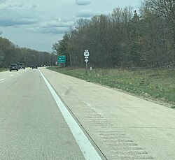
Near Howard City, M-46 exits the freeway and continues east along Howard City–Edmore Road, connecting the communities of Lakeview and Edmore. Between Six Lakes and Edmore, M-46 and M-66 run concurrently for about 3.5 miles (5.6 km).
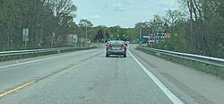
The route crosses the Maple River near Vestaburg before entering Gratiot County, where it is known as Monroe Road. After passing through Alma—where it intersects the Alma business loop and the US 127 freeway—it picks up the east-west leg of the US 127 business loop for St. Louis. M-46 continues through farm fields to Breckenridge, then follows Gratiot Road into Saginaw County via Merrill and Hemlock. Before entering Saginaw, it meets the northern terminus of M-52 and the southern terminus of M-47 near the Tittabawassee River.
From Saginaw to Port Sanilac
Entering the city of Saginaw, M-46 follows Gratiot Avenue past the Saginaw Country Club and through residential subdivisions. It crosses the Saginaw River via Stephens Street and Rust Avenue, eventually turning north on Warren Avenue and following Holland Avenue.
After an interchange with I-75/US 23, the highway leaves the Saginaw urban area and enters "The Thumb" region of the Lower Peninsula. In Tuscola County, the route passes through the Vassar State Game Area and crosses the Cass River north of Vassar. The landscape remains forested until the M-24 junction, after which agricultural fields dominate the view as the road approaches Kingston.
Upon entering Sanilac County, M-46 meets the M-53 junction at Van Dyke Road. Between Elmer and Sandusky, M-19 runs concurrently with M-46 for approximately 5 miles (8.0 km). The highway eventually crosses the Black River near Carsonville before reaching its eastern terminus in Port Sanilac at an intersection with M-25, just blocks from the Lake Huron marina.
| Region/Segment | Key Landmarks/Intersections | Notable Characteristics |
|---|---|---|
| Western Segment | Muskegon, US 31, Cedar Springs | Urban start, rural woodlands, NHS designated |
| Central Segment | US 131, Lakeview, Alma, Saginaw | Freeway concurrencies, agricultural land |
| Eastern Segment | The Thumb, Vassar, Port Sanilac | State Game Area, river crossings, Lake Huron terminus |
Frequently Asked Questions
What makes M-46 unique among Michigan highways?
M-46 is one of only three trans-peninsular highways in the Lower Peninsula, meaning it spans nearly the entire width of the peninsula from Lake Michigan to Lake Huron.
How is traffic measured on M-46?
MDOT uses Average Annual Daily Traffic (AADT), which is a calculation of the average number of vehicles that use a specific segment of the road on any given day of the year.
Which parts of M-46 are on the National Highway System?
The NHS designations apply to the section between the western terminus and US 31, as well as the stretch between Cedar Springs and the M-53 junction in Sanilac County.
Where does M-46 end?
The eastern terminus of M-46 is located in Port Sanilac at an intersection with M-25, situated just blocks away from the city's marina on Lake Huron.
Which other highways run concurrently with M-46?
M-46 shares segments of its route with M-37, US 131, M-66, and M-19.