Kaibab Plateau: A High-Altitude Landscape of Ecological Complexity
Rising above the arid lowlands of the American Southwest, the Kaibab Plateau stands as a lush, forested sanctuary within the larger Colorado Plateau. Spanning approximately 1,152 square miles, this high-altitude landform is situated primarily in Coconino County, Arizona, with a small portion extending into Kane County, Utah. Known by various names including Buckskin Mountain and Kaibab Mountain, the plateau is a region of dramatic contrasts, where heavy winter snows and cool forests meet the rugged edges of the Grand Canyon.
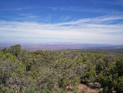
The plateau is geographically defined by its striking boundaries. To the south, it is bordered by the Grand Canyon, with elevations ranging from 8,800 feet down to just below 6,000 feet. Its western edge is marked by the steep, perpendicular walls of Kanab Creek Canyon, which acts as a natural barrier for local wildlife. To the east, the Houserock Valley features a unique marble platform created by a monoclinical fold, where geological strata dip downward by as much as 3,000 feet.
Key Facts
- Location: Coconino County, Arizona, and Kane County, Utah.
- Highest Elevation: 9,200 feet (2,800 m).
- Primary Ecosystems: Aspen, spruce-fir, ponderosa pine, and pinyon-juniper woodlands.
- Endemic Species: The Kaibab squirrel.
- Climate: Dry-summer humid continental (Köppen Dsb) at high elevations.
Geography and Physiography
The plateau is divided between the Kaibab National Forest and the North Rim portion of Grand Canyon National Park. One of its most notable features is the Esplanade, locally referred to by cowboys as "Sand Rocks." This extensive platform was formed through the weathering of Hermit shale, which eventually exposed a resilient layer of red Permian sandstone.
Climate and Weather Patterns
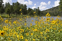
The climate of the Kaibab Plateau is characterized by significant seasonal shifts. While summer monsoons bring frequent thunderstorms, the winter months are defined by heavy snowfall, which can sometimes exceed 17 feet. This deep snowpack creates unique opportunities for backcountry Nordic skiing and snow camping.
At the plateau's highest points, the weather leans toward a dry-summer subalpine climate. June is typically the driest month, while the highest elevations often experience snowstorms between May and September. The following table provides a summary of the average annual climate data for the high point area (1991–2020):
| Month | Mean Daily Max (°F) | Daily Mean (°F) | Mean Daily Min (°F) | Avg Precipitation (in) |
|---|---|---|---|---|
| Jan | 38.8 | 27.0 | 15.3 | 5.33 |
| Mar | 45.6 | 33.0 | 20.3 | 4.39 |
| May | 60.5 | 46.9 | 33.3 | 1.17 |
| Jul | 76.6 | 62.8 | 49.0 | 1.99 |
| Sep | 68.2 | 54.4 | 40.7 | 1.89 |
| Nov | 46.0 | 34.3 | 22.6 | 1.88 |
The Kaibab Deer: A Lesson in Population Dynamics
The history of the Kaibab Plateau is inextricably linked to the story of the Kaibab deer. In the early 1900s, the plateau became the site of a significant ecological event that serves as a cautionary tale in wildlife management. Following years of overgrazing by domestic livestock and the removal of predators by ranchers, President Theodore Roosevelt established the Grand Canyon National Game Preserve in 1906 to protect the deer.
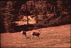
To ensure the deer population expanded, the United States Forest Service actively removed natural predators. Between 1907 and 1939, hundreds of mountain lions, wolves, coyotes, and bobcats were killed. This intervention led to a massive population explosion; estimates suggest the deer population surged to as many as 100,000 by 1924. However, this growth far exceeded the land's carrying capacity—the maximum population size an environment can sustain indefinitely.
By the mid-1920s, the deer began to starve as they over-browsed the available vegetation. This led to a rapid population crash. While early scientific interpretations focused solely on predator removal as the cause, modern ecologists like Graeme Caughley and Dan Binkley have suggested a more complex reality involving climate, grazing history, and preservation policies. Research into aspen stands suggests that severe overbrowsing by the massive deer population in the 1920s significantly altered the forest's age structure for decades.
Today, the Arizona Game Commission manages the area by balancing deer and predator populations and issuing hunting permits to maintain ecological equilibrium. The Kaibab story remains a vital tool in science education, teaching students about the unpredictable repercussions of human intervention in complex ecosystems.
Frequently Asked Questions
What is the significance of the Kaibab deer story in science?
The Kaibab deer controversy is used to teach students about population dynamics and the complexities of ecology. It demonstrates how human efforts to protect a single species can have unintended, far-reaching consequences on an entire ecosystem.
What are the primary types of trees found on the plateau?
The plateau is heavily forested with a variety of species, including aspen, spruce-fir, ponderosa pine, and pinyon-juniper woodlands.
Is the Kaibab Plateau part of the Grand Canyon?
While the plateau is bordered on the south by the Grand Canyon, it is a distinct landform. Parts of the plateau are managed as the "North Rim" of Grand Canyon National Park, while other parts belong to the Kaibab National Forest.
What is the endemic species of the Kaibab Plateau?
The Kaibab squirrel is endemic to this region, meaning it is found naturally nowhere else on Earth.
How does the climate affect activities on the plateau?
The heavy winter snowfall, which can reach depths of 8 to 10 feet or more, makes the plateau a destination for backcountry Nordic skiing and snow camping.