Ipiales: The City of Green Clouds and Gateway to Ecuador
Perched high in the Andean highlands of the Nariño Department, Ipiales is a city of striking contrasts and strategic importance. Known affectionately as la ciudad de las nubes verdes (the city of the green clouds) due to the unique greenish hue the clouds occasionally take on in the afternoons, Ipiales serves as one of Colombia's most vital border ports. Located just 3 kilometers from the Ecuadorian border and 82 kilometers from the capital city of Pasto, it is a hub of trade, faith, and cultural diversity.
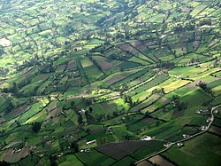
The city is situated on the high plateau of Túquerres and Ipiales, reaching an elevation of approximately 2,950 meters. This altitude makes it the highest major city in Colombia and one of the highest urban centers globally.
Key Facts
- Location: Nariño Department, Southern Colombia, near the border with Ecuador.
- Elevation: Approximately 2,898 to 2,950 meters above sea level.
- Primary Attraction: The Las Lajas Cathedral.
- Economic Driver: Border trade between Colombia and Ecuador.
- Climate: Cool subtropical highland climate (Köppen Cfb).
- Local Delicacy: Guinea pig (cavy), known locally as kuy or kuwi.
Culture and Religion
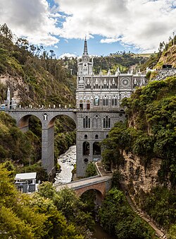
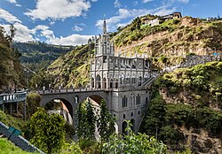
The spiritual heart of the region is the Las Lajas Cathedral, the episcopal see of the Roman Catholic Diocese of Ipiales. This architectural marvel is the municipality's primary attraction, drawing visitors from across the globe to witness its stunning design and setting.
Beyond its religious landmarks, Ipiales celebrates its multicultural heritage through the Blacks and Whites Carnival. This vibrant festival honors racial diversity, characterized by participants painting one another with makeup and a specific white soap called careoca.
History and Geography
The history of Ipiales is deeply intertwined with the movements of ancient empires. The Rumichaca Bridge, which crosses the Carchi River, is noted by Spanish chroniclers as the northernmost outpost of the Inca Empire before it was taken from the Pasto people in the early 16th century. The name Rumichaca is derived from Quechua, where rumi means stone and chaka means bridge.
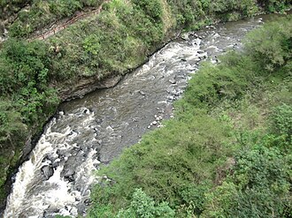
Geographically, the municipality is characterized by a diverse landscape that includes the Guáitara canyon, the Western Cordillera, and the Cofanía valley. The terrain is slightly wavy, featuring various climatic zones ranging from warm to cold. The region is defined by three major watersheds: the Jácome Benavides, the Julio, and the Guáitara River Basin. The Guáitara River is particularly renowned for its dramatic chasms and spectacular canyon.
Economy and Infrastructure
The economy of Ipiales is heavily reliant on its status as a land and air border port. It is the second most important border crossing in Colombia, facilitating intense trade with Ecuador. While the urban economy thrives on trade, small businesses, and tourism, the rural areas focus on agriculture, livestock, and the extraction of minerals such as oil in the Churuyaco jungle, clay in Tejar, and rock in Las Lajas.
Transport is facilitated by the Pan American Highway, which connects the city to the interior of Colombia and continues into Tulcán, Ecuador. For air travel, the city is served by the San Luis Airport.
Climate and Environment
Ipiales experiences a subtropical highland climate (Köppen Cfb). Despite its proximity to the equator, the high altitude keeps temperatures significantly cooler than the surrounding lowlands. The city enjoys a perpetual spring-like atmosphere, with temperatures rarely exceeding 20°C (68°F) or falling below freezing.
The year is divided into a rainier season (October to May) and a drier season (June to September). Rainfall is frequent throughout the year, averaging 925 millimeters annually.
| Metric | Average Value | Notes |
|---|---|---|
| Mean Daily Maximum | 16.0 °C (60.8 °F) | Consistent year-round |
| Daily Mean | 11.0 °C (51.8 °F) | Cool highland temperatures |
| Annual Precipitation | 874.6 mm (34.43 in) | Rainiest: Oct–May |
| Average Humidity | 83% | High relative humidity |
Frequently Asked Questions
What is the most famous landmark in Ipiales?
The most famous landmark is the Las Lajas Cathedral, an architectural masterpiece and the seat of the Roman Catholic Diocese of Ipiales.
Why is Ipiales called the "city of the green clouds"?
It earned this nickname because greenish-colored clouds frequently appear over the city, particularly during the afternoon hours.
What is the significance of the Rumichaca Bridge?
The Rumichaca Bridge is historically significant as the northernmost outpost of the Inca Empire and currently serves as the primary border crossing between Colombia and Ecuador.
What is the traditional food of the region?
A favorite local delicacy is the guinea pig, also known as cavy (Cavia porcellus), referred to locally as kuy or kuwi.
What is the weather like in Ipiales?
Ipiales has a cool subtropical highland climate with average temperatures around 11°C to 16°C, creating a perpetual spring-like environment due to its high altitude.