Interoceanic Highway: Connecting the Pacific and Atlantic Oceans
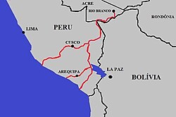
The Interoceanic Highway (also known as the Trans-oceanic highway) is a massive international infrastructure project designed to link the Pacific and Atlantic coasts of South America. Spanning approximately 2,600 kilometers (1,600 miles), this transcontinental route connects Peru and Brazil, facilitating movement across some of the most challenging terrains on Earth, including the Andes mountains and the Amazon rainforest.
The project was born from a 2004 agreement between then-President Alejandro Toledo of Peru and President Luiz Inácio Lula da Silva of Brazil. Completed in 2011, the highway represents a strategic effort to integrate regional infrastructure and boost trade between the two nations.
Key Facts
- Total Length: Approximately 2,600 kilometers (1,600 miles).
- Completion Date: Officially inaugurated in August 2011.
- Estimated Cost: US$1.3 billion.
- Infrastructure: Involved the construction or renovation of 2,600 km of roads and 22 bridges.
- Workforce: Approximately 6,000 people were employed during construction.
Construction and Regional Integration
In Peru, the project is managed under different names depending on the agency. The Ministerio de Transportes y Comunicaciones (MTC) refers to it as the Corredor Vial Interoceánico Sur Perú-Brasil, while ProInversion calls it the IIRSA SUR axis (Initiative for the Integration of the Regional Infrastructure of South America). This highway is a central piece of a broader national plan involving three longitudinal and 20 transversal highways.
The Peruvian section was divided into five separate concessions across two blocks:
2005 Concessions (Unpaved Road Development)
- Stretch 2: Urcos (near Cusco) to Inambari (Amazon Basin) — 300 km.
- Stretch 3: Inambari to Iñapari (Brazilian border) — 403 km.
- Stretch 4: Azangaro to Inambari — 306 km.
2007 Concessions (Paved Road Integration)
- Stretch 1: San Juan de Marcona (Pacific) through Nazca, Abancay, and Cusco to Urcos — 763 km.
- Stretch 5: Two branches connecting the Pacific ports of Matarani and Ilo to Juliaca and Azangaro — 752 km paved and 62 km unpaved.
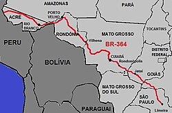
The Brazilian portion begins at the tri-border town of Assis Brasil and extends to Rio Branco via the BR-317. From there, it connects to the BR-364, the primary artery linking the region to São Paulo and the Atlantic coast.
Route and Geography
The highway begins at Peru's Pacific coastline, ascending through the Andes mountains before descending into the Amazon rainforest within the department of Madre de Dios. The route passes through key regional hubs, including Cusco, Cobija, and Rio Branco, eventually linking the Peruvian ports of San Juan de Marcona to the Special Export Zone (ZPE) of Rio Branco in Brazil.
A critical geographical feature of the route is the crossing of the Andean watershed (the dividing line between rivers flowing to different oceans). This occurs at two points: the Urcos-Inambari branch (roughly 7 km northeast of Urcos) and the Azangaro-Inambari branch (approximately 85 km north of Azangaro).
Economic Impact and Practical Results
Despite its ambitious design, the highway faced early challenges in trade volume. By 2017, reports indicated that the road was underutilized, with an average of only seven commercial vehicles per hour and a notable absence of Brazilian products heading toward Peruvian ports.
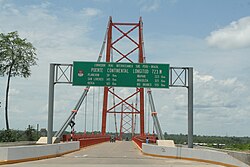
Data from 2009 to 2019 revealed that only 18% of the US$246 million in trade for the Brazilian state of Acre was conducted via the highway. This stagnation was primarily due to a missing link in the Brazilian network: the lack of a road bridge over the Madeira River between Rio Branco and Porto Velho. For years, transport relied on expensive, low-capacity ferries.
The situation changed with the completion of the Abunã bridge in 2021. This critical piece of infrastructure ended the road isolation of Acre, paving the way for future economic development.
| Feature | Details |
|---|---|
| Total Distance | 2,600 km (1,600 mi) |
| Primary Countries | Peru and Brazil |
| Key Brazilian Road | BR-364 |
| Total Estimated Cost | US$1.3 Billion |
| Major Infrastructure | 22 Bridges |
| Critical Recent Addition | Abunã Bridge (2021) |
Other Trans-Andean Projects
Beyond the Interoceanic Highway, there are ongoing intentions to develop another route between Paita and Yurimaguas in Peru. This proposed path would provide additional river access to the Amazon and Brazil, further enhancing South American connectivity.
Frequently Asked Questions
When was the Interoceanic Highway completed?
The highway was officially completed and inaugurated by the Peruvian President in August 2011.
What is the total cost of the project?
The estimated total cost was US$1.3 billion, though some analysts suggest the actual cost may have been higher.
Why was the highway underutilized for several years?
Trade was limited because the Brazilian state of Acre lacked a direct road connection to the rest of Brazil, requiring the use of expensive ferries to cross the Madeira River.
What is the significance of the Abunã bridge?
Completed in 2021, the Abunã bridge eliminated the need for ferries between Rio Branco and Porto Velho, ending the road isolation of Acre and enabling better trade flow.
Which Peruvian ports are linked to Brazil via this route?
The route links the ports of San Juan de Marcona, Matarani, and Ilo to the Brazilian network.