Highland Council Area: Scotland's Largest Local Government Region
The Highland council area is a unique administrative region in the north of Scotland. While often used interchangeably with the broader geographic region of the Scottish Highlands, the council area is a specific unitary authority—a single-tier local government body responsible for all local services.
Spanning a vast landscape of mountains, lochs, and coastlines, it is the largest local government area in both Scotland and the United Kingdom. From the peaks of the Grampians to the shores of the Inner Hebrides, the region is defined by its rugged beauty and sparse population.
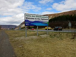
Key Facts
- Largest Area: It is the largest council area in the UK, covering 9,905 square miles.
- Administrative Hub: The Highland Council is headquartered in Inverness.
- Highest Point: Home to Ben Nevis, the tallest mountain in the British Isles.
- Population Density: Extremely low, with only 9 people per square kilometer as of 2024.
- Cultural Heritage: A significant center for both Scottish Gaelic and Scots languages.
Geography and Landscape
The Highland council area covers approximately 25,653 square kilometers, representing 32.9% of Scotland's total land area and 11.4% of Great Britain. Its borders touch Aberdeenshire, Argyll and Bute, Moray, and Perth and Kinross.
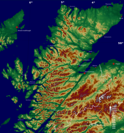
The terrain is diverse. While the inland regions are famously mountainous and dotted with lochs, the areas east of Inverness, the Black Isle, eastern Sutherland, and Caithness are predominantly low-lying. The region also extends to the west coast, including parts of the Inner Hebrides, most notably the Isle of Skye.
Geographic extremes include Dunnet Head (the northernmost point of Great Britain) and Corrachadh Mòr (the westernmost point).
Administrative History
The current structure of the region evolved through two major reforms. In 1975, the Highland Region was established as an upper-tier authority divided into eight districts: Badenoch and Strathspey, Caithness, Inverness, Lochaber, Nairn, Ross and Cromarty, Skye and Lochalsh, and Sutherland.
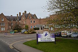
In 1996, the Local Government etc. (Scotland) Act 1994 abolished this two-tier system, replacing it with the single-tier Highland Council. This unitary authority manages the region from its headquarters in Inverness.
Demographics and Language
Despite its size, the region is sparsely populated. As of 2024, the total population is 237,290. This low density is comparable to countries like Russia or Bolivia. Historically, the area saw a significant population decline in the late 19th century; for instance, the population of Skye dropped from over 23,000 in 1841 to a low of 7,183 in 1971 before recovering in recent decades.
The region is a stronghold for Scotland's traditional languages. According to the 2022 Scottish Census, approximately 5.9% of residents aged three and over can speak or read Scottish Gaelic, while 23.9% are able to speak or read Scots.
Politics and Governance
The Highland Council operates with no overall political control. At the national level, the area is represented by four Members of Parliament (MPs) in the UK House of Commons and four Members of the Scottish Parliament (MSPs) within the Highlands and Islands electoral area.
Major Settlements
Inverness is the primary urban center and the largest settlement by a significant margin. Other key towns include Nairn, Thurso, and Wick.
| Settlement | Population |
|---|---|
| Inverness | 47,790 |
| Nairn | 10,190 |
| Thurso | 7,390 |
| Wick | 6,870 |
| Alness | 5,950 |
| Fort William | 5,600 |
Frequently Asked Questions
Is the Highland council area the same as the Scottish Highlands?
No. The Highland council area is a specific administrative boundary. The wider geographic and cultural region of the Scottish Highlands is larger and extends into neighboring council areas such as Aberdeenshire, Angus, and Stirling.
What is the largest town in the region?
Inverness is the largest settlement and serves as the administrative headquarters for the Highland Council.
Which famous mountain is located here?
Ben Nevis, the highest mountain in the United Kingdom and the British Isles, is located within the Highland council area.
What languages are spoken in the region?
English is the primary language, but the region has significant numbers of speakers of Scottish Gaelic and the Scots language.
How does the population density compare to the rest of Scotland?
The population density is very low, at approximately 9 people per square kilometer, which is less than one-seventh of the average density for Scotland as a whole.