Finnmark: Geography, Climate, and Natural Wonders of Northern Norway
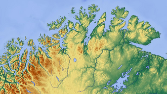
Finnmark is Norway's northernmost and easternmost county, serving as a vast frontier of dramatic landscapes and extreme environmental conditions. While it is the second-largest county in Norway by area—surpassing even the neighboring country of Denmark—it is the least populous, with a population of approximately 75,000 people. Its geography is defined by a massive coastline stretching 6,844 kilometers (4,253 mi), including 3,155 kilometers (1,960 mi) across its various islands.
The region is home to several geographic milestones. Knivskjellodden on the island of Magerøya is often cited as Europe's northernmost point on an island, while Kinnarodden on the Nordkinn Peninsula marks the northernmost point of the European mainland. In terms of urban centers, Honningsvåg claims the title of the world's northernmost city, and Vardø stands as Norway's easternmost town, situated further east than Istanbul.
Key Facts
- Area: Norway's second-largest county, larger than Denmark.
- Population: Approximately 75,000 (the least populous in Norway).
- Coastline: 6,844 km total, with 16.6% of the population living within 100 meters of the shore.
- Highest Point: Located atop the Øksfjordjøkelen glacier in Loppa Municipality.
- Record Salmon: The Tana River holds the world record for Atlantic salmon at 36 kg (79 lb).
- Climate Extremes: Recorded temperatures ranging from -51.4°C to 34.3°C.
Diverse Landscapes and Ecosystems
The terrain of Finnmark varies from the barren, wind-swept coasts facing the Barents Sea to sheltered fjords and lush river valleys. While some fjords are traditional glacial carvings, others are considered "false fjords" because they were not formed by glaciers. The northern coast hosts some of Norway's largest sea bird colonies, most notably Gjesværstappan and Hjelmsøystauran.
In the west, the region is more mountainous, featuring the Seiland Glacier and the Øksfjordjøkelen glacier. The latter was the last glacier in mainland Norway to calve directly into the sea, a process that continued until 1900. Conversely, the central and eastern regions are less mountainous, with land east of Nordkapp generally remaining below 300 meters (980 ft).
Vegetation and Wildlife
About half of Finnmark lies above the tree line, with much of the remaining area covered by small Downy birch. The most fertile regions are found in the Alta and Tana valleys. In the east, the Pasvik valley in Sør-Varanger Municipality features pine and Siberian spruce forests that are part of the Russian taiga vegetation. This specific valley boasts the highest density of Brown bears in Norway.
The region has also seen the introduction of invasive species. Muskrats, native to North America, were introduced to Finland and the Kola Peninsula in the early 20th century. They were first observed in the Alta area around 1960, with the first live capture occurring in Tana Municipality in 1969. Since 1988, the muskrat population has increased rapidly across Sør-Varanger. Other common wildlife includes lynx and moose, though these are rare along the coast.
The Finnmarksvidda Plateau
The interior is dominated by the Finnmarksvidda, a vast plateau with elevations between 300 and 400 meters (980 to 1,310 ft). Comprising 36% of the county's area, this plateau is characterized by numerous lakes and river valleys. It is world-renowned for the tens of thousands of reindeer owned by the Sámi people, as well as its intense swarms of midsummer mosquitoes. Additionally, the Stabbursdalen National Park protects the world's northernmost Scots pine forest.
Climate and Weather Patterns
Finnmark experiences a wide range of climates depending on the proximity to the ocean and elevation. The interior plateau has a continental climate, known for the coldest winter temperatures in Norway. In Karasjok, the temperature plummeted to -51.4°C (-60.5°F) on January 1, 1886. This area can also experience significant summer heat, with a recorded high of 32.4°C (90.3°F) in July, creating a rare European temperature amplitude of 84°C.
Coastal areas, such as Loppa Municipality, benefit from the ice-free ocean, resulting in milder but windier winters. The temperature difference between the coast (Loppa) and the interior (Karasjok) is approximately 6°C, a gap comparable to the difference between Loppa and London.
Climate Classifications
| Region | Köppen Classification | Climate Type | Characteristics |
|---|---|---|---|
| Karasjok & Lowlands | Dfc | Subarctic | Cold winters, mild summers |
| Loppa | Cfc | Subpolar Oceanic | Milder winters, influenced by ocean |
| Northeast Coast | ET | Arctic Tundra | July average temperature below 10°C |
| High Elevations | N/A | Alpine | Found above 100-500m depending on location |
The most hospitable areas are typically the sheltered fjords, such as Altafjorden, which combine the warmth of the summer with winters that are less severe than the interior. However, the coast remains vulnerable to winter storms that can disrupt air and road travel.
Celestial Phenomena
The Midnight Sun and Polar Nights
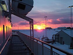
Located north of the Arctic Circle, Finnmark experiences the Midnight Sun from mid-May to late July, providing continuous daylight. Conversely, from late November to late January, the region enters the Polar Night, where the sun remains below the horizon. During midwinter, the only light is a bluish twilight that lasts a few hours around noon.
The Northern Lights
Finnmark is situated within the Aurora Borealis zone. Because the region's dry climate often results in clear skies, Alta Municipality became a primary site for studying the Northern Lights. Consequently, Alta is frequently referred to as the "city of the northern lights."
Frequently Asked Questions
What is the northernmost point of Europe in Finnmark?
Depending on the definition, Knivskjellodden on the island of Magerøya is considered the northernmost point on an island, while Kinnarodden on the Nordkinn Peninsula is the northernmost point on the European mainland.
Which river in Finnmark is most famous for fishing?
The Tana River is the most famous, providing the largest catch of salmon of any river in Europe and holding the world record for Atlantic salmon at 36 kg (79 lb).
How extreme are the temperature swings in Finnmark?
The temperature swings can be extreme; for example, Karasjok has recorded a low of -51.4°C and a high of 32.4°C, resulting in a temperature amplitude of 84°C.
What is the Finnmarksvidda?
The Finnmarksvidda is a large interior plateau covering 36% of the county, characterized by elevations of 300 to 400 meters, numerous lakes, and the reindeer herding practices of the Sámi people.
Why is Alta called the city of the northern lights?
Alta is known by this name because its dry climate and frequent clear skies made it an ideal location for the early scientific study of the Aurora Borealis.