Ensenada de Barragán: The History and Geography of a River Plate Bay
Located along the shores of the Río de la Plata, the Ensenada de Barragán (Barragán's Bay or Cove) is a small but historically significant body of water. Situated approximately 40 kilometres (25 mi) southeast of Buenos Aires, Argentina, this area lies within the Ensenada district of the Buenos Aires province and is centered around the city of Ensenada.
Over the centuries, the geography of the bay has shifted. Since the 17th century, the cove has experienced partial silting—the process where water becomes clogged with sediment—leading the area to be considered part of Isla Santiago (Santiago Island) today.
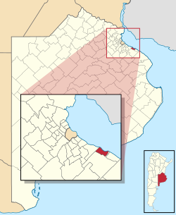
Key Facts
- Location: 40 km southeast of Buenos Aires, Argentina.
- Toponymy: Named after Antonio Gutiérrez Barragán, who purchased the land in 1629.
- Historical Role: Served as a natural port and a fortified defensive position known as Fuerte Barragán.
- Modern Status: Now integrated into the Port of La Plata industrial complex.
Historical Evolution
Early Exploration and Settlement
The coastal region surrounding the bay was first mapped in 1520 by Ferdinand Magellan during his historic circumnavigation of the globe. However, permanent settlement did not occur until the early 17th century, when the bay was settled by Hernandarias. The bay's name originates from 1629, when the land was sold to Antonio Gutiérrez Barragán. The town of Ensenada was later officially founded in 1801.
Military Significance and Fuerte Barragán
Until the mid-19th century, the bay's geography made it an ideal natural port. To protect this strategic asset, Spanish governors and the Viceroys of the River Plate fortified the area. These defenses included the construction of a defensive wall and several batteries, leading the site to be known as Fuerte Barragán (Fort Barragán).
Modern Infrastructure and the Port of La Plata
The regional landscape changed significantly in 1882 with the foundation of La Plata, the new capital of the Buenos Aires province. To support the growing city, a new port was constructed between Ensenada and the neighboring town of Berisso.
Because of the silting of Barragán Bay and Isla Santiago, engineers created a dredged channel—an artificial waterway cleared of sediment—to connect La Plata with the River Plate. This channel, along with the natural Río Santiago, facilitates the operations of the Port of La Plata, which currently serves primarily as a hub for industrial freight.
| Period/Year | Event/Status | Key Figure/Entity |
|---|---|---|
| 1520 | Coastal region first mapped | Magellan |
| Early 17th Century | Initial settlement of the bay | Hernandarias |
| 1629 | Land sale and naming of the bay | Antonio Gutiérrez Barragán |
| 1801 | Foundation of the town | Local Administration |
| 1882 | Foundation of La Plata and new port construction | Buenos Aires Province |
Frequently Asked Questions
Where is Ensenada de Barragán located?
It is a small bay on the Río de la Plata, located about 40 kilometres southeast of Buenos Aires in the Ensenada district of Argentina.
Why is the bay named after Barragán?
The bay takes its name from Antonio Gutiérrez Barragán, who purchased the land in 1629.
What happened to the natural port of the cove?
The cove has partially silted since the 17th century, and the area is now considered part of Isla Santiago.
What is Fuerte Barragán?
Fuerte Barragán refers to the fortifications, including batteries and a defensive wall, built by Spanish governors and Viceroys of the River Plate to protect the bay.
How does the modern Port of La Plata connect to the sea?
The port uses a dredged channel that cuts through the silt of Barragán Bay and Isla Santiago, as well as the natural Río Santiago channel, to reach the River Plate.