East Coast Geography and Climate
The Eastern Seaboard of the United States is a region of immense environmental diversity, stretching from the rugged borders of Canada to the tropical reaches of the Florida Keys. This vast stretch of land is defined by a transition of climate zones and a unique geological history that has shaped its coastlines, river systems, and urban centers.
Key Facts
- The East Coast is divided into three primary climate regions: cold-winter continental, temperate, and subtropical.
- Southern Florida is the only region in the continental United States with a tropical climate.
- The Atlantic hurricane season officially runs from June 1 to November 30.
- The region is largely a low-relief, passive margin coast, except for Eastern Maine.
- The Atlantic Seaboard fall line separates the coastal plain from the Piedmont region.
Climate Regions of the East Coast
The climate of the East Coast varies significantly based on latitude, moving from harsh winters in the north to year-round warmth in the south.
Humid Continental Climate
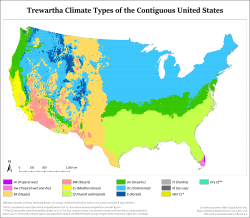
Spanning from the US-Canadian border south to southern Rhode Island and western Maryland, the humid continental climate (Dfa/Dfb/Dc) is characterized by warm to occasionally hot summers and cold winters. Frequent snowfall is common, particularly in New Hampshire, Vermont, and Maine. In this region, at least one month averages below 0°C (32°F), while four to seven months average above 10°C (50°F).

Warm Temperate Climate
From southern Rhode Island southward—including New York City, Long Island, most of New Jersey, Delaware, Maryland, Virginia, and western North Carolina—the region experiences a warm temperate climate (Cfa/Do). This zone is marked by long, hot, humid summers and cool to cold winters with occasional snow. The coldest month maintains a mean temperature of 0°C (32°F) or higher, with six to seven months averaging above 10°C (50°F).
Humid Subtropical and Tropical Climates
The area from the southern Delmarva Peninsula and southeast Virginia through central North Carolina down to central Florida is humid subtropical (Cfa/Cf). This region features hot summers with frequent, brief thundershowers and mild, drier winters, with at least eight months averaging above 10°C (50°F).
Further south, from south-central Florida to the Florida Keys, the climate becomes tropical (Af/Aw/Ar). This is the only tropical zone in the continental US, remaining warm to hot year-round with all 12 months averaging above 18°C (64.4°F) and typically remaining frost-free.
Oceanic Climate
The least common climate type is the oceanic climate (Cfb/Do). It is found only in specific areas: the southern Appalachian Mountains, Block Island, Nantucket, and parts of Cape Cod (Chatham and the Outer Cape). This zone sees monthly averages between 0 and 22°C, with winter precipitation more likely to be rain than snow, though heavy snow can still occur.

Geological Features and Coastal Geography
Except for Eastern Maine, the East Coast is a passive margin coast with low relief. The northern areas of New England were shaped by Pleistocene glaciation, which created offshore islands such as Fishers Island, Block Island, Martha's Vineyard, and Nantucket.
Moving south from northern New Jersey, the coastal plain widens. It is separated from the Piedmont region by the Atlantic Seaboard fall line. This geological feature often marks the limit of river navigation and has historically served as the site for many prominent cities.
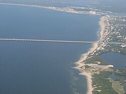
From Long Island to Florida, the coast is frequently defined by barrier islands and sandy beaches. Notable examples include Cape Canaveral in Florida and the Outer Banks of North Carolina. In the far south, the Florida Keys are composed of limestone coral, hosting the only coral reefs on the U.S. mainland.
Weather Hazards: Hurricanes
While landfalls are not frequent, the Eastern Seaboard is vulnerable to hurricanes. The official Atlantic hurricane season lasts from June 1 to November 30, though storms can occur outside this window. Significant storms that have impacted the region include Hazel, Hugo, Bob, Isabel, Irene, Sandy, Florence, Isaias, Henri, and Ida.
Climate Summary Table
| Climate Type | Primary Region | Key Characteristics | Temperature Marker |
|---|---|---|---|
| Humid Continental | New England to Western MD | Cold winters, frequent snow | < 0°C in at least one month |
| Warm Temperate | S. Rhode Island to W. NC | Hot, humid summers; cool winters | ≥ 0°C in coldest month |
| Humid Subtropical | SE Virginia to Central FL | Hot summers, mild winters | > 10°C for 8+ months |
| Tropical | South-Central FL to Keys | Warm/hot year-round, frost-free | > 18°C all 12 months |
| Oceanic | Cape Cod, Block Island, S. Appalachians | Moderate temperatures, rain-heavy winters | Monthly averages 0°C to 22°C |
Frequently Asked Questions
What is the only tropical climate in the continental United States?
The tropical climate is found exclusively in the region of Florida extending from the south-central part of the state down to the Florida Keys.
When is the official Atlantic hurricane season?
The official season runs from June 1 to November 30, although hurricanes can occasionally form and make landfall before or after these dates.
What is the Atlantic Seaboard fall line?
The fall line is the geological boundary that separates the coastal plain from the Piedmont region, often marking the head of navigation for East Coast rivers.
Which areas of the East Coast have an oceanic climate?
The oceanic climate is rare and limited to the southern Appalachian Mountains, Block Island, Nantucket, and the Outer Cape and Chatham on Cape Cod.
How was the coastline of New England shaped?
The far northern areas of New England and its offshore islands were shaped by Pleistocene glaciation.